

 17 Best Things to Do in Mount Shasta, CA – Your Ultimate Guide">

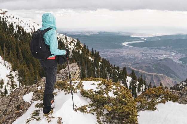
Start with a sunrise hike and coffee in town to set the pace for Mount Shasta exploring. The climb rewards you with dramatic views of the peak and easy access to trails through pine forests. Take an aside to Shasta Caverns and check trout streams nearby for a quick, refreshing moment.
Plan your day around known destinations and parking options. You’ll find rooms in cozy lodges close to the town center, plus ample parking around the main plaza. The destinations span lakes, a cavern, and quick nature trails, all within a short drive.
In warm months, boating on Lake Siskiyou pairs with light hiking and a green forest stroll. In winter, the area shifts to snow sports and crisp air. Youre free to switch gear and keep the itinerary flexible, using a concise loop that covers the major attractions, from the Cavern through river views and back to town for a meal.
Keep the plan practical with updates from the local bureau and management. The tourism bureau provides current safety advisories and seasonal access notes. Your day centers on a compact route, with a pause at a cafe and a quick run-through of gear before returning to your lodging and the land.
This mix gives you an amazing, compact itinerary that captures Mount Shasta’s varied appeal. From rugged trails to calm water, cavern visits to cozy rooms, youve got a flexible framework that works in winter or summer. Youre ready to explore, with parking tips and a pace that stays enjoyable.
Mount Shasta Local Activities: A Practical Guide
Begin with the Lake Siskiyou loop: a flat, easy circuit hugs the lake, and the crystal water reflects Mount Shasta in the morning. Park at the public lot near the boat ramp and complete the loop in under an hour, then grab a bite at a cafe on Mount Shasta Boulevard.
In downtown, explore independent shops and a memorial park; the county tourism bureau lists hours and family-friendly events. The website keeps current notices, and it’s a good place to verify parking, restrooms, and kid-friendly routes. The feel of the town is welcoming, especially on Sundays when local farmers bring produce to the market.
For a scenic hike, the McCloud Falls trail sequence–Lower, Middle, and Upper–offers crystal water views along a moderate path. Expect several springs along the route; plan 2-3 hours for a relaxed loop, and wear sturdy shoes because some sections become rocky or slightly difficult.
Drive to Castle Crags in Trinity County for dramatic granite spires and forest overlooks. The drive is extremely scenic and the routes accommodate both easy strolls and longer treks; plan a half-day and bring extra layers. For a longer adventure, prepare a route that climbs gradually rather than a steep ridge. A short drive into trinity reveals rugged scenery and a million-dollar panorama at the top.
History and heritage: nearby ruins of old mining towns touch the public historic narrative, and a small train museum memorializes local rail lines. Some house museums preserve period furnishings, and shares of archival photos appear on the county’s website. Overlook walkways include cable railings for safety, set against the californias public lands backdrop.
Practical tips: always pack water, snacks, sunscreen, and a light jacket; the weather shifts quickly on Mount Shasta’s ridges. Use the exit routes on major roads to avoid congestion; driving times vary with snow, and a flexible plan helps you hit more highlights. If you’re visiting with kids, pick looped routes with flat segments and frequent rest stops; you’ll find a super, extremely family-friendly mix of scenery and small-town charm.
Best Hiking Trails for All Levels Near Mount Shasta
Start with Black Butte Trail: starts just outside Mount Shasta City and runs about 3 miles round trip. The grade stays easy, so it’s friendly for beginners, yet the views are panoramic. Highlights include a historic fire lookout, a mix of green forest and open meadows, and several smaller side loops if you want to explore more. It’s a beautiful first hike in the area and comes with a couple of extra viewpoints to chase in the same trip. After finishing, you can explore the town or plan a visit to one of the breweries there.
Heart Lake Trail starts at Bunny Flat and climbs to a high alpine lake surrounded by granite ridges. This moderate hike runs roughly 6–7 miles round trip and gains about 1,200–1,600 feet. Expect some steep switchbacks and a rewarding lake scene at the end. It’s included in many itineraries as a classic Mount Shasta experience and a favorite for exploring higher green meadows and crystal water.
Hedge Creek Falls offers a quick, family-friendly option near Dunsmuir. The loop is under 1 mile and keeps to boardwalks and gentle paths that cross the stream. It’s there for a relaxing half-day, and you’ll find a few attractive viewpoints along the cascade. It pairs well with a drive to smaller towns and a stop at a local cafe.
Shasta Bally delivers a steep, rugged option with a 3–4 mile out-and-back starting near Castella. The trail climbs through open forest into rocky slopes, with exposed sections near the top. The payoff is a panoramic overlook of Mount Shasta, the Trinity Alps, and the green valleys to the north. This option is ideal for a shorter, high-contrast day when you want big views without a long approach.
Lake Siskiyou Trail loops around the lake starts at the north shore and runs 6–8 miles depending on your chosen route. It alternates shaded forest with open shoreline, offering flat stretches and gentle rollers. The route passes attractions such as a lakeside beach, coves, and bird-watching spots. It’s a reliable long day that still keeps a comfortable pace for families and active travelers alike.
Tips: check trailheads and weather before you go, bring water and sun protection, and pack a light snack. Start early on weekends to beat crowds and heat, and consider pairing a hike with a visit to nearby redding and other attractions. If you’re driving from redding, you’ll reach the area after a scenic drive, and the largest nearby city offers additional options for dining and breweries after your hike. When a route feels crowded, switch to a smaller loop or a quieter section. There are extra opportunities throughout the region to extend your day or shift to a shorter walk, depending on your mood and conditions. The first priority is safety; however, plan for variable weather, wear sturdy shoes, and stay on designated paths. With that approach, the hikes near Mount Shasta deliver highlights you’ll want to repeat across seasons.
Guided Tours: Scenic Drives, Nature Walks, and Town Highlights
Start with the scenic drive: join an established, 60–90 minute loop that begins at the lakehead Visitor Center, open daily. The route takes you along the river, across open meadows, and climbs to a waterfall overlook. Signs mark the entrance to the ramp that leads to the overlook; the location offers striking views of Mount Shasta and the distant powerplant skyline. The guide explains geology and local history; this must not be missed by avid first-timers.
Nature walks: The avid guides lead you through an established park trail system, with options from a nice, easy 1.5-mile loop to a moderate 3-mile forest path. Across the river, you may spot osprey and deer. The routes are clearly signed and well marked, with brief stops to observe a waterfall, trees, and birds. If you want more, the guide can take you farther along the forest edge and then back toward the river access point.
Town highlights: After the walk, the tour offers a short visit to the Mount Shasta town center, where you can sample a local beverage and browse shops along the main street near Derby. In november, the evenings glow with lights and friendly conversations. The route touches redding location and a riverside park, then returns to Lakehead to finish the loop. If a site is closed, the guide offers an alternate stop so the experience stays smooth. thats the goal: concise, friendly exploration that blends scenery with community stories.
Waterfall Hikes: Hedge Creek, McCloud Falls, and Panther Meadows
Begin with Hedge Creek Falls for a quick, scenic warm-up: a simple 0.4–0.5 mile loop that takes about 20–30 minutes. The flat path leads to an overlook where you can photography the cascade and even glimpse rock coves along the shore of the creek. If you miss the main turnout, another short side path keeps you on a straightforward route. In November, soft morning light makes the falls glow without crowds.
- Distance: 0.4–0.5 miles round trip
- Time: 20–30 minutes
- Terrain: flat, simple; family friendly
- Highlights: waterfall, sheltered overlook, coves along the shoreline
- Tips: wear water-friendly shoes; stay on designated paths; watch for slippery boards in colder months
Then continue to McCloud Falls, a compact sequence of Lower, Middle, and Upper falls along a short route. Plan a 1.0–1.5 mile loop if you want to see all three, or pick a single fall if time is tight. The trail is mostly easy with a few steps near the viewpoints, and the forest backdrop makes for strong scenery and great photography.
- Three falls: Lower McCloud Falls, Middle McCloud Falls, Upper McCloud Falls
- Distance: about 1.0–1.5 miles round trip if you visit all three
- Time: 45–90 minutes
- Terrain: easy to moderate; boardwalk sections near the falls
- Best seasons: spring runoff through fall; winter can bring slick spots
- Tips: parking is convenient off Highway 89; carry water; you can link with Hedge Creek as a short loop beforehand
- Notes: from redding, plan a day trip of roughly 2.5–3 hours driving each way
Finish with Panther Meadows for a longer, rewarding hike that showcases mountain scenery and alpine meadows. The loop runs about 4.5–5 miles with roughly 700–900 feet of elevation gain, suitable for a steady 2.5–4 hour effort. Start early in warm months to maximize wildflower color and wildlife watching; in November, be prepared for cooler temps and possible early snow, which can tighten the upper sections.
- Distance: 4.5–5 miles round trip
- Elevation gain: ~700–900 feet
- Time: 2.5–4 hours
- Terrain: rolling slopes through forests and meadow clearings
- Highlights: scenic outlooks overlooking Mount Shasta; distant views toward the Lassen region on clear days
- Best season: July–October for vibrant meadows; November may bring snowlines and more challenging footing
- Tips: bring layers and water; a longer stroll pairs well with a later stop at nearby towns or breweries
- Practical note: parking and basic service are limited at trailheads, so plan ahead
Winter Activities: Skiing, Snowshoeing, and Snow Play at Mount Shasta
If youre lucky with fresh powder, start at Mount Shasta Ski Park for reliable, well-maintained runs and a friendly vibe; youre likely to find beginner slopes, a short lift lineup, and rental gear that gets you on the snow quickly.
Snowshoeing on the north side offers quiet forest routes; the following trails are well-marked and easy to navigate. You can trace fresh tracks in powder, pause at coves and near natural springs, and enjoy walking through a snow-blanketed landscape, with a hedge of pines framing the trail. Dress in layers and bring water and snacks; microspikes help on icy patches.
Snow play zones near downtown Mount Shasta welcome families with sledding, tubing, and snowman-building. They offer safe, open lawns and plenty of space to practice balance on rolling powder. If you need gear, rental options are available at local shops, so you do not have to carry everything from home. Their staff can point you to the most family-friendly routes.
Safety and gear: check daily conditions, keep to marked routes, and pack a small daypack with water, extra layers, and a headlamp for late returns. Useful items include a waterproof shell, insulated boots, traction devices, and a helmet if you plan to ski or ride. The following tips help you have a smooth day in natural snow, and you can receive updates through the local system at the skifield.
Expand your day with nearby adventures. Lassen to the north adds higher-elevation scenery and longer snow-covered horizons, while the Trinity region offers backcountry routes for experienced walkers. For a sheltered contrast, consider Hirz Caverns tours for an underground cool-down, then trace a few craft stops in downtown shops to sample local art and treats. If you have time, you can also craft a mixed itinerary that blends outdoor time with cozy indoor breaks at lodges and cafes.
Prime Sunrise and Photography Spots Around Mount Shasta
Begin your sunrise photography at Castle Crags State Park, where the first light carves dramatic spires and high-contrast shots arrive quickly. From the south approach you roll down the highway to north-facing overlooks, catching the warm colors as the shadows pull down. This route puts you in a league of standout options, and the state’s park pullouts stay accessible for a quick setup. Near the approach you’ll notice limestone outcrops catching the first light, a detail that makes the scene feel timeless. These views touch your heart and become part of your library for years. Once you lock in a solid composition, these places stay with you on many trips.
Next, swing to Lake Siskiyou Overlook near Mount Shasta City for reflections that hold on calm mornings. The route to the overlook is simple, with accessible pullouts that suit early shoots between highway stretches. In season, light shifts fast; in winter, fog or frost over the water adds drama. The views here work for both sunrise and sunset, and you can catch crisp color before many cities wake up.
Hedge Creek Falls and Mossbrae Falls near Dunsmuir offer easy options that stay accessible even on busy mornings. Take the inside loop behind Hedge Creek for simple forest textures and a misty curtain at dawn. These places reward patience: you can catch the light when it’s most forgiving, though you should arrive before the crowds. In winter the steam from the falls blends with town mist, creating atmosphere you can capture later.
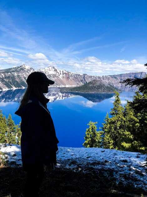
Castle Lake on the north side of Mount Shasta gives reflective water and long horizons. From the roadside overlook you look down toward the lake and the distant town, with broad views that hold through the season. In summer a light breeze smooths the surface; in winter the water can freeze into a glassy plane that catches alpenglow. That combination makes versatile images you can reuse in these projects.
For a forest-driven morning, head to the McCloud River corridor and the small cities along I-5. The north-facing banks provide texture from pine needles and moss, and early light on the water creates clean silhouettes of the peak. The route links several cities and offers a quiet contrast to the open lake spots, ideal if you want a simple, inside shot after a long drive. Once you’ve found your favorite angle, you’ll return year after year, catching moods that shift with the season.
After a shoot, cap the morning with practical tips: pack a lightweight tripod, a wide and a mid telephoto lens, and a jacket for cold waits. These spots work through much of the year, with conditions varying by season; once the light blooms you’ll know why so many photographers return again and again. If you want a celebratory pause, swing to a local dinners spot and grab a beer while you review your frames.