

 Насолоджуйтесь озерами Алабами – Ваш путівник до легкого громадського доступу">

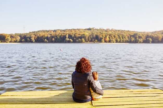
Start at Sipsey Marina on the north shore, take the short dock, and reel in crappie within minutes. This move gets you on productive water quickly, making more time for you and your crew.
With input from hosts and stakeholders, map more than a dozen slipways within a 20-mile arc along north-facing shores near Stevenson and McFarland Acre; every site provides parking, toilets, and calm slips for anglers and sailors alike.
Bring a light rod and a simple reel setup; early light off the Sipsey water favours crappie, so probe shallow shorelines and weed lines near marinas, then switch to a small jig to target crappies as depth increases. This plan will boost your action.
Better etiquette from hosts and stakeholders translates into more chance for anglers and others: keep voices down, observe posted rules, and practice catch-and-release for undersized crappie; this behaviour helps maintain access across acre-sized segments of the north shore for future visits.
You'll explore new spots, and with careful behaviour and tips from Stevenson, McFarland, and Marina teams, the day will have a higher chance of success; the network of ramps and shorelines will stay welcoming for sailors and anglers alike.
Lake Tuscaloosa Public Access: Practical Points for Visitors
Start at first light to minimise waiting for ramps and parking; choose the main launch area near marinas to secure quick entry and a smoother plan for the day.
Pack essential equipment: life jackets for everyone on board, a sturdy anchor, rope, signalling whistle, cool box, sun cream, a map, and a basic depth finder if available.
Check current water levels and creek inflows before departing; some slipways close after heavy rain, so have a backup plan and monitor the forecast for wind shifts above the tree line.
Marinas along the border and inside the creek, which offer launch slips and basic amenities, provide numerous options in this county, with signage listing hours and permitted vehicles.
Catfish fishing around creek mouths is classic here; use appropriate bait, follow size limits, and obtain any required licence as part of responsible recreation and respect for the heritage of this waterway.
Safety and stewardship: wear life jackets, keep eyes peeled for weather changes, and observe no-wake zones and speed limits; aggressive behaviour by operators spoils the experience and must be avoided to preserve the resource.
Reason this site matters: it anchors local heritage, supports double-check routines for family trips, and provides a beautiful, incredible escape for yourself seeking a quick nature break; the above-water views are excellent for photography and relaxation.
If you need a licence for catfish, verify state rules ahead of time and carry the paper or digital proof on the boat.
Best Public Access Points and Parking near Lake Tuscaloosa
Recommendation: Park at Riverbend Park’s main car park on River Road for immediate waterfront access; the 40-space gravel car park is located about 5 miles north of the city centre and places you in a welcoming setting with a clear backdrop for anglers. There is something for every angler when you start here.
Beyond Riverbend, marinas along the shoreline offer launch points and shaded seating; looking to fish almost any time, you can find a site that suits your boat and gear. Cane stands along several coves create a natural backdrop that appeals to every seasoned angler.
Another strong option is Jackson's Landing, located toward the Duncan corridor. This acre-sized parking area offers direct water access and easy-to-navigate ramps, making it a reliable base for visiting families and solo anglers alike. The surrounding shoreline and wildlife also contribute to the setting, creating a calm backdrop for a day on the water.
Overall, you’ll find the areas around Lake Tuscaloosa offer miles of shoreline with parking areas and entry points. Seasoned anglers know to visit during the warm early morning and late afternoon windows, when the water looks best and the surrounding mood is calm.
Additionally, to participate actively, check posted site rules and seasonal restrictions; visiting anglers frequently create a routine that includes multiple sites along the coast and aims at another favourite destination. There, you’ll discover a compact network of sites designed to accommodate different craft and gear, offering convenient options for fish, picnics and exploration.
| Site | Parking | Distance (miles) | Facilities | Примітки |
|---|---|---|---|---|
| Riverbend Park Boat Launch | Main car park; gravel car park; limited overflow | 5 | Paved ramp; basic facilities | Good for anglers and kayaks; wide waterfront view; reed-lined banks nearby |
| Jacksons Landing | Small lot; roadside overflow | 6.8 | Dock; fishing dock; rubbish bins | Sunrise-friendly; popular with seasoned anglers; vibrant backdrop |
| Duncan Spur Access | Acre-sized grassy plot | 8.2 | Boardwalk to water; benches | Family-friendly; surrounding shoreline provides varied fishing spots |
| West Shoreline Trailhead | Tarmac car park; larger capacity | 12.5 | Toilets (portable); seating | Ideal for day trips; miles of shoreline for exploring |
Boat Launch Availability and Regulations
Phone ahead to reserve a landing slot at marinas and confirm hours; arrive 15 minutes early to secure a lane and parking. Official schedules populate quickly online, so check the latest info for Eufaula, Cherokee, Thomas-area ramps; there are plenty of options, and must-visit spots such as Duncan Landing can save you time. If you know Arley Inlet, include it in your route as a fallback option.
Carry required safety gear: life jackets for each occupant, valid boat registration, and a horn. Avoid confusion near coves and shallow zones; some zones enforce idle or no-wake limits to protect sensitive habitats, with white markers along docks indicating boundaries. Surface conditions can shift quickly after storms – check wind, rain, and wave height before launching; last-minute notices at the ramp bulletin board are common.
Availability varies by lake and season; most ramps around Eufaula and Cherokee area offer several launch lanes, marinas, and fuelling options. In the Duncan and Thomas corridors, a few ramps are apart from the main complex, so verify with staff. There are last-minute changes during tournaments; keep an eye on signs and online updates. Some ramps report surface water conditions and spotted debris; plan accordingly. Beyond the main ramps, there are trails and nearby coves where you can land a boat and stay sheltered while loading or unloading.
Anglers chasing crappie will find schooling patterns along shallow coves with submerged structure. Target first light or dusk along weedlines and brush near the surface; spots around eufaula and cherokee zones are well known must-visit for spring runs. Bring sonar to locate bait, and stay mindful of other boats at the ramp; there are some areas with high activity near the must-visit landing points. Spotted bass and other species also show up near the trails around coves and banks.
General etiquette: give way to inbound boats, keep clear lines, and avoid blocking a launch during busy periods. When operating near sensitive shoreline habitats, reduce wake and slow down as you pass coves. Inspect the trailer and boat surface for hazards before leaving the ramp, and report issues to staff. For updates, rely on local marinas and ranger notices; they publish more updates and schedule changes throughout the season.
Swimming, Fishing, and Shoreline Safety at Lake Tuscaloosa
Use designated swim coves first and wear a U.S. Coast Guard-approved life jacket for everyone near the surface; that's why supervision and boundaries matter. The lake has been a favourite among locals, and looking for a calm spot by the shoreline helps beginners. Look for calm water and follow posted signs; in late spring through early summer, the month offers warmer water, but always verify weather and wind before heading out. Appreciate the setting and the surrounding nature, and be mindful of wildlife as you choose your favourite spot.
Swimming requires staying within marked boundaries; never swim alone, avoid diving, and keep distance from boats moving through coves. The setting can shift with wind and weather, so observe the surroundings and stay clear of channels used by watercraft. Always scan underwater features like weed beds and rocky pockets that can hide hazards under the surface.
Five practical tips help balance recreation and safety: check wind and water temperature; wear life jackets; keep kids within arm’s reach; stay in coves with clearly defined edges and safe bottom structure; and pack out all rubbish and picnic supplies to protect habitats and beds of aquatic vegetation.
Fishing near coves and along shallow shores supports several species, with bluegills among the easiest to catch. Look for beds of aquatic vegetation that attract fish and monitor signs of activity to locate hotspots; use appropriate gear and follow local size and creel limits. Practise catch-and-release for undersized specimens and minimise handling to protect their role in the ecosystem.
Hiking trails skirt the lake and traverse diverse habitats; visiting the shoreline with respect helps preserve the setting and surroundings. When visiting, appreciate such habitats along the shore and keep noise low near nesting sites. Pack a picnic and enjoy the views, but keep everything clear, reuse containers, and ensure lids and covers are secured to protect wildlife and avoid litter that can affect beds and coves.
Picnic Areas, Toilets, and Waste Disposal at Access Sites
Рекомендація: Обирайте місце, яке поєднує повний пікніковий комплекс, поблизу туалети та утилізацію відходів в одній, чітко позначеній зоні, щоб зменшити повернення під час пікових періодів та стежити за безпекою та чистотою.
- Місця для пікніківмасив затінених столиків та лавок на ділянці площею акр; рівна земля, поруч трава та спокійна обстановка покращують враження; чудові краєвиди вздовж берега підвищують популярність; таблички оголошують правила та години роботи; дозволено грилі лише у визначених місцях; переносити обладнання для їжі та прибирання.
- Restrooms: розташовані поблизу головної парковки або стежки; досвідчені служби технічного обслуговування підтримують їх у чистоті протягом сезону; перевіряйте години роботи на інформаційних дошках; очікуйте портативних туалетів у пікові місяці березня або в періоди високої завантаженості; переконайтеся, що мило, папір та дезінфікуючий засіб для рук є у наявності; доступні об’єкти позначені стандартними знаками.
- Утилізація відходів та переробка вторсировинипоблизу кожного кластера надано бінові контейнери та чітко марковані контейнери для переробки відходів; використовуйте їх і тримайте відходи у контейнерах до досягнення місця утилізації; якщо контейнери повні, запакуйте відходи в пакет і заберіть їх з собою на наступний пункт; завжди забирайте все, що принесли з собою, і уникайте залишення сміття будь-де на березі.
- Planning and tips: проконсультуйте опубліковані карти, щоб з'ясувати, де розташовані об'єкти; це дозволяє спланувати американську експедицію у відомих зонах відпочинку; час залежить від сезону, повний спектр послуг доступніший за межами зими; березень, пізня весна та літо пропонують найкращі пригоди; на популярні вихідні натовп; ця територія потребує підготовки та деякого обладнання; візьміть з собою невелику сумку, яку можна носити будь-де.
Дозволи, збори та зміни сезонного доступу
Почніть з 12-місячної ліцензії на риболовлю у прісній воді; їх потрібно підтвердити на сайті ADCNR перед будь-яким виїздом. Одноденні дозволи зазвичай коштують близько $6; річні ліцензії для резидентів коштують приблизно $25, а річні ліцензії для нерезидентів сягають $60. Ціни варіюються залежно від місця проживання та сезону, тому перевірте останні цифри, оскільки зміни відбуваються з бюджетними циклами.
Зони спорядження та запуску, якими керують парки або місцева влада, можуть стягувати невеликі збори за вхід або запуск у деяких місцях; достатньо місць для паркування є поширеним поблизу точок доступу до Eufaula, створюючи чудовий фон для природного досвіду та зручний початок для рибалок.
Сезонні зміни впливають на дальність та час: скидання з гребель можуть спровокувати коливання рівня води, зміни вітру та умови берега, які впливають на те, де рибалити. Деякі місця закриті під час технічного обслуговування або високих витрат; години роботи можуть змінюватися залежно від переходу на літній час, тому перевіряйте поточний статус на вихідні, оскільки це впливає на витрати та плани.
Рибалки повинні досліджувати кілька місць входу, щоб максимально збільшити можливості; на Еуфаулі синьочели та краппі дають стабільну, неймовірну активність у мілководних затоках. Використовуйте легкі шнури (тест 4-8 фунтів) і невеликі джиги або живу приманку; для тих, хто шукає професійний старт, чартерні сервіси працюють на Еуфаулі та в інших місцях, створені, щоб допомогти новачкам і сім'ям отримати швидку перемогу; район Флоренції має мальовничі краєвиди та легкі спуски.
Поради щодо сезонного планування: ведіть простий журнал показників рівня води, прогнозів вітру та стану рампи; плануйте достатньо часу для дослідження, коригуйте плани та створюйте гнучкий маршрут, що відповідає фону кожної водойми. Пам’ятайте про бюджет витрат і поважайте ліміти вилову риби та встановлені правила.