

 Судноплавство – важливі поради та інструменти для безпечного та впевненого плавання">

Починайте кожну подорож із контрольного списку планування перед відправленнямоновлювати графіки, перевіряти відомі небезпеки, встановлювати навігаційні точки та підтверджувати дані про погоду та припливи. Під час підготовки переконайтеся, що час екіпажу присвячено одному чітко структурованому розпорядку. Це зменшує несподіванки в останню хвилину та допомагає отримувати оновлення протягом 10 хвилин, якщо умови змінюються.
Традиційний skills blend with modern systems. Використовуйте перевірки компаса разом з електронними навігаційними картами та AIS, щоб show ситуація над водою та під нею, допомагаючи в навігації жвавими каналами. Проводьте постійний перегляд безпеки: перевіряйте вогнегасники, рятувальні жилети та сигнальне обладнання.
Примітки щодо процедур в гавані: підтримуйте консервативну швидкість у завантажених каналах (6–8 вузлів), дотримуйтесь встановлених схем руху суден, і keeping чітко від зайнятих пробігів. Проведіть швидку 2-хвилинну перевірку після кожного заходу в гавань, а потім відновіть планування з новими даними.
Під час поїздок поблизу green markers, verify bearings by known landmarks, time passes, and measure accuracy проти течії. У річкових водах Баварії адаптуйтеся до вузьких каналів і сильнішої течії.
Діліться плановими даними з екіпажем, записуйте notes on deviations, and update the log after each shift. In case of a sudden situation, активуйте тривогу, перейдіть на резервне живлення systems, і тримай time маючи на увазі.
Морська навігація: Навігація за залізним компасом – практичні поради та засоби для безпечного та впевненого плавання
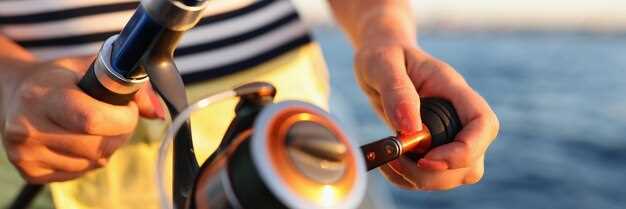
RecommendationВстановіть міцний магнітний компас з чітким безелем, встановіть його в захищеному, вільному від перешкод місці та тримайте запасний офлайн-компас на борту. Під час руху під вітрилами перевіряйте компасний курс із земними орієнтирами та картою, створюючи надійне джерело істини навіть у разі відмови електроніки.
Як читати підшипникиВизначте напрямок, прицілюючись на фіксовану точку та зчитуючи азимут з обертового кільця; потім відкоригуйте значення, враховуючи поточну відмінність та, якщо потрібно, відхилення від системи вашого судна. Запишіть градуси, хвилини та секунди у вигляді скорочень на польовому аркуші, а також залиште примітку з чимось на кшталт N, E, S, W для швидкого посилання. Певні кроки зменшують помилки у вітряну погоду.
Використовуйте орієнтири вздовж маршруту, щоб підтвердити розрахований курс; також зверніть увагу, що швидкі зміни вітру або пориви можуть відхилити судно від чистого магнітного курсу. Як резервний варіант, використовуйте фіксовані точки на березі, які видно з марин і відомі з карт планування. Комбінація силового компаса та незалежного джерела інформації тримає вас на шляху, навіть якщо GPS виходить з ладу.
Список обладнанняПереконайтеся, що компас обладнаний та встановлений з належним кріпленням, перевірте кабелі або проводку, якщо вони є частиною більшої системи; майте під рукою заряджену батарею як резерв, щоб прилад залишався функціональним, коли основне живлення вимкнено. Встановіть другий пристрій як швидкий резерв та позначте область встановлення позначкою для змін екіпажу. Дивіться інформаційні дошки в маринах щодо магнітних перешкод поблизу кабелів живлення порту; баварія пропонує місцеві вказівки від влади; використовуйте їх як єдине джерело істини.
Плануйте та практикуйтеКоли створюються плани, відзначайте область та потенційні місця з магнітними перешкодами (поблизу силових кабелів, двигунів або навантажень). В економічних термінах, носіть компактну ламіновану картку з магнітною варіацією по області. Каярам слід чергувати між магнітним азимутом і істинним курсом на карті, щоб уникнути відхилення. Ця звичка підвищує впевненість, особливо вночі або в тумані.
NoticeСлідкуйте за двигуновими кабелями та електричними лініями, щоб запобігти перешкодам; тримайте зону навколо компаса вільною від феромагнітних предметів, уникайте металевих шестерень і тримайте портативні пристрої подалі від компаса; підтримуйте приблизну відстань у футах від джерела, яке може спотворити показання. Пожежна небезпека поблизу паливних ліній вимагає швидкої реакції та видалення, якщо порив вітру спричинить іскру. Катерам у марині слід використовувати одномоторний режим роботи, коли вони залежать від магнітного курсу; якщо ви помітили відхилення, перевірте знову з картою та відкоригуйте відповідно до вимог влади.
Офлайн робота remains practical on long crossings; this aligns with ownership and the system approach, enhancing resilience when power or electronics fail. The technique can be tested in different area conditions; bavaria’s coast offers hills that alter line-of-sight to landmarks, so rely on those sights to verify bearings. Keep a single, economical kit that includes a spare battery, a laminated field card with abbreviations, and clear plans for switching between magnetic bearing and charted courses.
Магнітна навігація компасом: основні практики для безпечного, впевненого плавання
Завжди встановлюйте магнітний курс на бажаний маршрут перед вильотом., а потім перевірте це за допомогою GPS або орієнтирів. Це допоможе вам не збитися зі шляху у водах, де панують течії та зміни вітру, дозволяючи вам плавати з більшою впевненістю.
Regular learning і following структурований class допомагає будувати awareness of differences між показаннями компаса та реальним напрямком. Використовуйте offline practice щоб закріпити м’язову пам’ять: гойдайте компас, порівнюйте з даними на карті та записуйте спостереження у вашому ownership notes.
Тримайте портативні та стаціонарні інструменти в serviceперевірте наявність тріщин, замініть рамку та переконайтеся, що charge є достатнім для резервних пристроїв. Коли поїздки включають fishing або наближаючись around shoals, use the bearing to steer a secure arc і періодично перевіряйте.
Водії повинні розуміти, що many фактори впливають на зчитування: локальна варіація, differences між картою та дисплеєм, а також впливом металевих предметів. Завжди тримайте data from multiple means маючи на увазі та спільно розробляючи стійку звичку, щоб залишатися на потрібному курсі.
Практичний розпорядок: перевіряйте напрямок, потім перевіряйте ще раз після повороту або зміни води, течії чи вітру; ведіть журнал, переглядайте awareness data після кожного tripі include нотатки про те, як технологія і products performed offline and online.
Pre-Departure Compass Check: Declination, Deviation, and Swing
Set your magnetic compass to the latest declination from the updated chart or source on deck, then lock the setting. Cross-check with the deviation table to ensure the numbers reflect current waterways, and log the change in a quick table aboard to support your plans and trips. Document the detail of the adjustment to aid crew work during pre-departure checks.
Compute the true heading by applying two corrections to the observed compass heading: deviation (D) from the vessel’s deviation table, and variation (V) from the chart. Use the equation TC = CH + D + V, with signs taken from the sources. Example: CH 090°, D = +2°, V = +5° yields TC 097°. When D or V are negative, adjust accordingly to keep your plotting on the intended type of course.
Perform a swing check while berthed: rotate the wheel through 360 degrees and compare the compass reading with a fixed reference bearing from landmarks or a charted line on the plotter. Note what you observe, expect swing to stay within roughly 0–6° on a typical hull; larger swing indicates residual magnetism or nearby damage. If you detect excess swing, pause, reassess deviation data, and rely on a quick, powered backup such as GPS overlay to confirm the route while you adapt.
If the hull or compass shows damage, or interference from gear is suspected, rely on a gyro compass or GPS-based track as a stand-in. When you're plotting trips through channels, a lake passage, or long waterway legs, keep a stand-on bearing in mind and enable a quick cross-check with the GPS plot to stay carefree and on plan.
Document the updated data in a dedicated table on deck, mark источник as the data source, and share the results with everyone aboard, including the charter crew. This detail keeps your plans aligned, reduces risk during long trips, and enables carefree travel between waterways.
Reading the Compass at the Helm: Navigating with Pitch, Roll, and Spray
Lock the helm and confirm a stable bearing by aligning a magnetic compass with sense4boat data, and use aids such as a gyro or fluxgate to cross-check readings; verify signal quality via hdop readouts, which is more accurate than a single instrument. If the numbers drift beyond ±3 degrees after a 15-second check, then re-centre and re-check against the tide.
On deck, shifting seas produce spray that fogs the compass card. Keep your gaze through the binnacle, practising calm helm corrections, and react quickly to small deviations; blasts from waves can push readings off, so strive to adjust before another span passes. This reduces collisions, a clear advantage in distress situations. Stay mindful of regulations.
Bilge pump readiness matters; ensure lines are clear and checks don’t interfere with cockpit instruments.
Learning updates from a network of owners, Bavaria sail owners, and suppliers of products keeps you informed. Sense4boat readings, hdop trends, and numbers flux matter more than a single instrument. Informed care stays steady; you become more capable as conditions change through dives, tide, blasts, and gusts, and the approach can feel carefree yet precise. This significantly sharpens decision making.
| Condition | Action | Примітки |
|---|---|---|
| Pitch > 5° or roll > 6° | Return to bearing; recentre; cross-check HDOP | Cross-check with sense4boat; then lock |
| Spray obscures readout | Recentre; adjust to keep readings aligned | Keep eyes on cards; monitor spots |
| Reading drifts on spots | Record numbers; compare with network updates | Become consistent; updates 'elp. |
Correct for Variation and Deviation in Real-Time Bearings
Always validate bearings in real time by cross-checking magnetic readings with GPS positions and known visual cues, including buoys and upstream references to confirm alignment with the intended course.
- Baseline setup: pull local variation from a current chart or offline apps, then set that value in your compass settings and the electronics display, creating a single reference used in quick checks.
- Continuous cross-check: maintain alignment between magnetic bearing and GPS-derived course; compare positions against marina charts and a few fixed marks; when a discrepancy is detected, adjust bearing values immediately and log changes with concise abbreviations.
- Crew responsibilities: assign a quick observer to watch visual cues and buoys; keep the crew informed, involve your electrician when hardware readouts drift, and ensure the log is updated with care.
- Interference and drift: be mindful of blasts from nearby equipment or power lines that can shift readings; recalibrate, verify compass alignment, and test against a known set of courses to restore accuracy.
- Offline resilience: if connectivity or apps go offline, rely on positions, visual cues, and a trusted set of tracks; maintain a small record of bearings, positions and courses to speed real-time decisions.
- Maintenance discipline: keep electronics well maintained, replace batteries, and review settings regularly; there's a need to verify readings after any calibration, and the crew should review the log after every trip; involve your electrician for a hardware check.
- Reference tools: use marina charts, buoys, and equipment to confirm alignment; with many inputs, accuracy improves; always align your heading with a good visual reference and a backup from apps or GPS.
Cross-check bearings with charts, GPS, and visible landmarks
Check bearings against three sources: charts, GPS, visible landmarks before every leg. In practice, run the three-source check to confirm your position within the area, then update as you move. This approach increases accuracy when approaching busy zones such as wakeboarding zones, and when dealing with depths that change with tides.
- Charts and abbreviations: Read the fundamental bearing shown on the chart. Use the chart source; verify scale, grid, declination, and abbreviations in the key. Note depths in the area and record what you see in your log tables to reference later.
- GPS and sensors: Compare GPS bearing with chart bearing; check sensor status, time, and update rate. If readings diverge beyond a small margin, switch to dead reckoning and relying on landmarks until readings align. Set an alarm if drift persists beyond 2–3 minutes.
- Visible landmarks: Identify at least two fixed features on shore or buoys; take visual bearings to each, compare with chart positions, and verify your location every few minutes. This critical step helps when GPS is degraded or signal is limited.
- Handling discrepancies: If misalignment exceeds a preset threshold, execute a rapid cross-check using what you know about depths and the ship’s wake. Update course gradually to re-establish your path.
- Record keeping: Save information in a dedicated log; include time, location, measured bearings, and notes. Refer to books or class materials, and fill in tables with abbreviations you can glance at quickly. This ensures everything is captured.
- Practical practice: Before class or during drills, run this routine on a known journey route. Practicing increases tolerance to misalignment as you sail near zones and other craft. What you learn here becomes baseline behaviour when sailing in unsettled conditions. This practice will increase your accuracy.
Maintaining the Compass: Cleaning, Storage and Magnetisation Prevention
Start with a clean, magnetically neutral base: wipe the compass face with a soft microfibre cloth, rinse with fresh water, and dry thoroughly. Use a mild soap if needed; avoid solvents. Keep the unit above the deck to minimise moisture ingress and prevent water marks on the glass. After cleaning, verify the north reference against a distant mark or marks on a chart, confirming accuracy before heading out on the journey.
Maintain proper storage: when not in use, place the compass in a dry, cool container away from ferrous hardware, high-current cables, and any electronic sensors that could induce stray fields. The goal is to keep the dial balanced; avoid exposure to ferrous metals that can magnetise the dial. Store with the face up to help back bearings and maintain readability.
Magnetisation prevention: keep the instrument away from beidou antennas and other magnet sources around the cockpit; a single magnet can cause drift, producing multipath-like errors when plotting routes. If you notice drift, perform a simple calibration against a known north reference. This must be part of your awareness at all times.
Simple checks during plotting: use sense4boat to compare compass output with GPS sensors; taking updates from authorities when away from shore; stay aware of distances and routes to limit collisions. If sensors show a discrepancy, develop understanding that a great deal of external influence can upset readings and adjust accordingly.
Charter crews, especially in Bavaria, must stay aware of a routine that keeps the compass reliable. Start each day by checking alignment, and stay prepared with a back-up bearing. The aim is a carefree journey with reliable bearings, whilst authorities oversee safety and distances to other vessels along busy routes.
Regular checks create awareness of multipath and external interference that sensors may reveal. Building understanding of how external factors affect readings helps you stay able to plot more accurately. A simple, repeatable routine–clean, store, magnetisation precautions–keeps distances and routes accurate, making back-up bearings usable when conditions are rough. Stay mindful of authorities and be proactive in maintaining performance on the journey ahead.