

 Sardinia Sailing Itinerary – The Ultimate 7-Day Coastal Route">

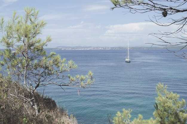
Start with a 7-day coastal loop that begins in Olbia and heads toward La Maddalena, delivering a first taste of Sardinia’s azure bays. Hire a capable boat for 2–4 guests, keep daily legs in the 20–35 nautical mile range, and you’ll enjoy a pearl-like mix of coves, charming town squares, and calm anchorages.
From Olbia, sail a sheltered leg to La Maddalena, where you can swim in turquoise water and explore the old town’s marina. In the afternoon, visit Caprera with its pine forests and quiet coves, or swing to Santa Teresa di Gallura to stroll the waterfront, pop into a portside bakery, and sample handmade gelato while chatting with locals visiting the harbor.
Continuing along the northern arc, anchor near Porto Cervo and Cala di Volpe, then ease toward the eastern Gulf of Orosei. A swim in azure coves, a stroll through a sunny town square, and snorkeling around shipwrecks tucked into sheltered reefs add intrigue to the day.
As you head toward the southern coast, drop anchor near Cagliari’s historic harbor and wander the maze of alleys in the Castello district, with nearby tavernas offering fresh seafood. A morning market, a lunch of bottarga, and an afternoon sail toward Villasimius or Costa Rei deliver exceptional scenery and calm water. For a final touch, anchor near Portoscuso at sunset and observe the rocky headlands glow.
With a number of routes and time-saving options, this itinerary fits a range of wind patterns and sea states. Where you anchor, nearby towns invite you to stroll the waterfront, sample seafood, and plan a second visit. The southern leg reveals a different mood–hushed coves, rugged cliffs, and sunsets that feel like a pearl in a marine canvas. If conditions shift, habe a backup plan and adjust to a sheltered bay; the day doesnt have to follow a rigid map, and that makes the route truly intriguing.
Sardinia Sailing Itinerary
Begin with La Maddalena archipelago for a sheltered, special start that yields easy anchorage and a network of marinas.
-
Day 1: Olbia to La Maddalena archipelago
- Sail along the northeast coast into protected waters, choosing Cala Gavetta or Cala Spalmatore for a calm first mooring.
- Explore the medieval town of La Maddalena and Caprera, soaking up the ambience and recording a few clear waypoints for them to reference later.
- Ask giuseppe at the marina for help with weather checks and the best routes along sardinias coast.
-
Day 2: La Maddalena to bonifacio ( Corsica )
- Cross the pass to bonifacio, watching for currents between Sardinia and corsica.
- Dock in the francese-influenced harbor, where the backdrop of white cliffs and ancient walls frames a striking scene.
- While you stroll the old town, enjoy fresh seafood and the quiet ambience before the next leg.
-
Day 3: bonifacio to lavezzi
- Head toward lavezzi, a protected marine area with small, intimate anchorage options among the islets.
- Keep to short hops between coves to minimize wake and maximize sheltered time in crystal water.
- Use a mark on the chart for a late-afternoon stop and enjoy the stillness above the seabed.
-
Day 4: lavezzi to southeast Sardinia ( Villasimius / Costa Rei )
- Proceed southeast along the Sardinian shore, selecting a stop in Villasimius or the Costa Rei marinas for a lively yet protected base.
- Enjoy the ambience of seaside taverns and local shops, then settle into a quiet anchorage for the night.
- Note how the coastal roads frame distant hills, giving a sense of continuity between sea and land.
-
Day 5: Villasimius to Cagliari
- Slip into Cagliari’s marinas, where a sheltered harbor awaits and town life is an easy reach by tender.
- Stroll through the Bastion and marina area, sampling seafood and pausing at shops along the water’s edge to mark souvenirs.
- Keep a flexible schedule to catch a sunset over the Poetto backdrop, then rest in a protected anchorage nearby.
-
Day 6: Cagliari to Golfo di Orosei (Ogliastra)
- Chart a course north to the Gulf of Orosei, with standout anchorages near Cala Luna or Cala Goloritzè when conditions allow.
- In the afternoon, drop anchor near secluded coves and savor the marine clarity and rugged coastline.
- Adjust plans if seas rise; this segment rewards patience with calmer water and dramatic scenery.
-
Day 7: Golfo di Orosei to Olbia or return loop along sardinias east coast
- Return toward Olbia by following the east coast’s bays and roads, stopping at a final anchorage to celebrate the week.
- Review the chart, make notes for a future mark, and reflect on the week’s highlights across the Sardinian coast.
Last-leg start point, optimal departure time, and routing for Friday
Depart Cala Gavetta, La Maddalena, at 08:50 local time. Sail northeast along the protected front of the maddalenas archipelago, avoiding the lavezzi shoals to the south, and steer toward Porto Cervo to follow the coast. This choice delivers a scenic, dazzling backdrop of cliffs, coves, and shimmering water, with the afternoon sun creating beautiful color on the shorelines.
Distance Cala Gavetta to Porto Cervo: 40-45 NM. Target 6.5-7.5 hours at 6-7 knots; ETA around 15:20–15:45. Mark Capo Ferro as the turning point, then continue along the coast to Porto Cervo marina for a lunch and fuel break before the next leg.
Porto Cervo to Olbia leg runs 25-30 NM in 4-5 hours at 6 knots, with an ETA near 19:30–20:00. Dock Olbia by 20:00, enjoy dinner ashore at a locally-sourced spot, and let the community vibe set the tone for the final evening. The route keeps you close to sheltered coves and ports along Costa Smeralda, exposing a beautiful and shimmering maritime backdrop.
For years, geduldig weather checks help you stay in protected waters, and hatten gusts often ease by the afternoon. If wind shifts, shorten the leg to Porto Cervo or swing directly into Olbia’s outer harbor; also keep a backup stop at Golfo Aranci. Carry a small book for notes on marks, tides, and timings. This plan pairs maddalenas charm with Olbia’s ports, presenting two worlds of beauty and practicality, and ends with a dinner that highlights locally caught seafood.
Final-night mooring options: harbors, tides, and docking tips
Pick a protected harbor for your final night–Olbia or Golfo Aranci are solid, easy-to-reach options that keep seas calm and docking straightforward. This choice will give you quick access to water, fuel, and a delightful boutique dining scene, plus a center of shops and caprerabudelli tasting rooms along the quay. The utmost priority is shelter from swell, so prioritize harbors with solid breakwaters and marina staff who can help if you arrive after hours.
If you crave a coastal cruising vibe while staying sheltered, target inner harbors such as Porto Rotondo or Santa Teresa di Gallura. The guardia costiera can confirm slip numbers and tide windows, and many harbors offer reserved berths for late arrivals. On Tuesday and Saturday evenings, some marinas report lighter traffic, which makes final-night stays calmer and easier. From these places you can stroll to intriguing waterfront boutiques and enjoy a glass of local wine. Some locations also offer caprerabudelli tastings and other small delights you can savor after docking.
Tides in Sardinia stay modest, but you still need to time your approach. Plan arrivals near slack water if possible and verify with the marina center before you depart, as a calm entry reduces risk of contact with other vessels. Use the local tide table and wind forecast to predict swells above the quay; this information helps you select the best berth. A quick check at the center will also help you locate a protected slip near the center of the marina.
Docking tips for the final night: approach slowly from the seaward side, align with the fingerprint, and keep a short, steady swing if gusts arrive. Deploy soft fenders and angle two lines to bow and stern cleats, plus a spring line to control drift. Call the guardia or the marina office when you’re five minutes out so staff can guide you to the right slip. In protected harbors, berths are available for visiting yachts; verify depth and clearance with the dock master before you tie off. In most harbors, berths accommodate average cruising yachts; confirm the slip size with the center desk to ensure a smooth fit.
After you secure the boat, stroll to the quay for a breathtaking sunset and a delightful finale. Watch for creatures–seabirds and crabs skittering along the pilings–and savor hatt en pastries with caprerabudelli at a sea-front boutique. This experience, from the intriguing market to the quiet harbor lights, offers a memorable end to a coastal cruising itinerary. vivre the moment, this final night in Sardinia will stay with you long after you depart the places you visited.
Weather, wind shifts, and safety checks for Day 7
Check the 48‑hour forecast and set a contingency plan for wind shifts on Day 7, then secure one reliable mooring in a protected bay before the first gust arrives.
Day 7 runs along the northeast side of Sardinia with Corsica nearby; the mediterranean breeze shifts through the day, and funnel effects between headlands can tighten gusts. Corsica boasts rugged coastlines and famous rock formations that concentrate wind in narrow channels, so expect wind shifts near shore and gusts that can surprise a line of moorings. The francese coast adds micro‑currents that can alter boat speed on small triangles of water, so plan for changes that affect both sides of the boat.
In the morning, anticipate a northeast tilt around 12–18 knots, rising to 18–25 knots by midday, with occasional bursts to 28 knots in sheltered channels. By late afternoon the wind can back toward the southwest or west as thermal heating builds, which changes the sail plan and requires quick reefing. Those shifts create brief lulls suitable for sunbathing on deck, but they also demand steady vigilance when approaching rocks, bays, and protected harbours that often double as sheltered flotilla moorings.
Safety checks flow from the forecast into action: verify that all crew members wear life jackets when gusts sharpen, secure harness lines for those on deck, and keep a tether ready near the helm. Maintain a ready weather watch with VHF on channel 16 and a backup handheld radio, because timely alerts save moments if a shift comes quickly. Conduct a quick engine check and confirm steering responsiveness, bilge pump readiness, and sail‑trim reef lines; changed conditions require fast sail alterations and clear communication among crew on every person onboard. That thats why a compact, practiced routine matters more than a lengthy plan.
När du planerar manövrar nära kustlinjen, identifiera skyddade vikar i förväg och notera vilka som är lämpliga för flottiljens ankringsstrategi. De mest kända vikarna erbjuder lugnt vatten för solbadsuppehåll, men bara efter att du har verifierat skydd mot ström och vindförändring. Använd markerade bojar och etablerade anfarterna i dessa skyddade områden för att minska risken för gruppen, och håll ett öga på revpunkter och klippledgar som bildar farliga sidor om prognosen skärps.
| Checklist item | Details | When |
|---|---|---|
| Väder och vindskift | Monitor NE 12–18 kt morning, gusts 28 kt in channels; watch for shifts toward SW/WSW in late day; funnel effects near Corsica coastlines | Morgon till eftermiddag |
| Moorings och flottiljeplan | Bekräfta skyddade vikar, verifiera tillgängliga bojar, för‑bind stötfångare, samordna linhantering för flera fartyg | Before departure |
| Säkerhetsutrustning | Flytvästar på alla gäster, selar redo, flytande föremål, VHF-apparater laddade | Försågling och under resa |
| Navigation och kommunikation | Diagram över nordost Sardinien och Korsika leder samman områden; AIS/GPS-kontroller; kanal 16 beredskap | Morning |
| Båtsystem | Motorlåsning, styrning, segelrevlinor, länspumpstest | Pre‑sail |
| Crew readiness | Tilldela roller för vindförändringar, bekräfta linhanteringsuppgifter, informera om solskydd och hydrering | Innan seglats |
Navigationsvägpunkter: exakt spår, landmärken och tidplan för fredagsseglingen
Avgång från Alghero hamn kl. 08:00, styr 306° längs västkusten, håll dig 1 NM utanför kusten för säkerhet och för att hålla sjöfåglarna framför. Använd dessa vägpunkter för att hålla en exakt kurs, med kontroll av landmärken och ETA-tidsramar som passar en avslappnad men effektiv dag på vattnet.
- WP1 Capo Caccia Lighthouse – avstånd 9 NM, riktning 306°. Landmärke: vitt fyrtorn uppe på klippan; udde såg dramatisk ut när gryningen ljusade upp berget. ETA 09:30 vid 5.5–6.0 knop. Noteringar: passera 0,8 NM utanför för att undvika stenar; justera för vindbyten.
- WP2 Isola Piana västra ingång – avstånd 8 NM, kurs 288°. Landmärke: Isola Piana med grunda sandbankar på närmhåll. ETA 11:00; fart 5,5–6,0 knop. Noteringar: bekräfta säker vatten med djupmätare; håll utkik efter fiskelines nära lågvatten.
- WP3 Porto Conte-udspets – avstånd 6 NM, riktning 296°. Landmärke: tallskogsbeklädd udde, med den lilla hamnen Porto Conte i sikte. ETA 12:15; fart 5,5–6,0 knop. Anmärkningar: skyddat vatten framför; förbered för lunchstopp vid behov.
- WP4 Cala Reale Cove – avstånd 5 NM, kurs 281°. Landmärke: viken med den vita sandstranden inbäddad mellan klipporna; idealisk för en enkel solbadspaus. ETA 13:45; hastighet 5,0–5,5 knop. Noteringar: förtöjning eller bojning på västsidan; kontrollera tidvattenströmmar.
- WP5 La Pelosa approach (Torre della Pelosa) – avstånd 14 NM, kurs 265°. Landmärke: Torre della Pelosa och ikonisk vit sand. ETA 16:00; hastighet 5,5–6,0 knop. Noteringar: reservera en boj om vinden skiftar; solnedgången ser fantastisk ut över vattnet; valfri stopp för ett kort dopp eller ett besök till resorteringsljusen för en kvällshöjdpunkt.
Ruten erbjuder arkitektoniska klippor, som Capo Caccia, och en sådan rå charm att kusten såg särskilt inbjudande ut. Vinden från väst hjälpte dig att glida smidigt längs kusten, bortom grundläggande segling, till en lugn, naturskön slutpunkt vid La Pelosa. Denna plan håller alla bekväma och säkert ombord, med försäkringar och charteröverväganden kontrollerade innan avfärd. Om ett möte flyttas till tisdag, justera tiderna med ungefär 30 minuter för att rymma all besättning och hålla schemat tajt för alla inblandade. Utsikten inkluderar solbad, sjöfåglar som kretsar runt fören och en kväll som genljuder med nordvästra sardiska charmen – höjdpunkter som alla kan njuta av, besöka och minnas runt udden, med segel stadiga och humöret på topp.
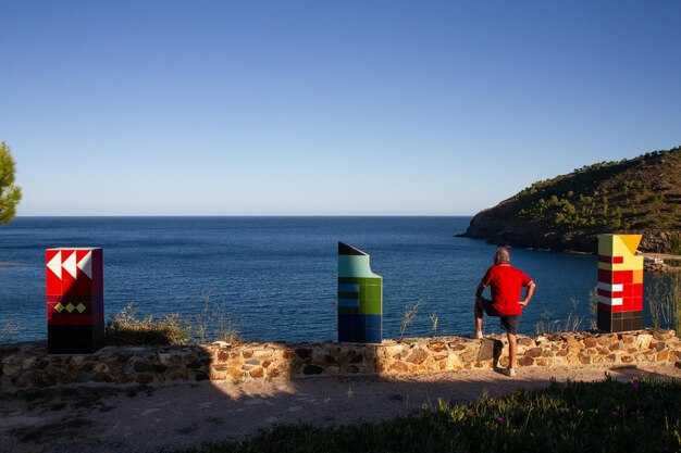
Onshore finale: middag, solnedgångsplatser och fotomöjligheter efter att ha dockat
Ankare i en skyddad hamn och promenera till en uteservering vid vattnet för en utsökt, franskinspirerad skaldjursmiddag som gör avslutningen på land verkligen exceptionell. Hamnar längs kusten erbjuder liknande alternativ, så du kan välja den atmosfär du gillar.
Välj en sandterrass nära marinan där du har en grön glöd från lyktor och en direkt utsikt över vattnet. I Italiens sydöstra kustområdens mariner, leta efter platser som kombinerar frodiga trädgårdsmiljöer med havsvind; beställ grillad dorado med citron och en fransk beurre blanc, och avsluta med en panna cotta. En frisk Vermentino från regionen passar bättre än ett tungt rött vin, särskilt efter en passage till sjöss. För en rekommendation rekommenderar jag att du väljer ett bord med vattenreflexer.
Solnedgångsplatser: För solnedgång, sikta mot en grön ud längs sydostkusten eller marinan västra brygga, där stjärnans färger blomstrar och vyerna sträcker sig mot världarna bortom. Fotografer kommer att uppskatta de långa siluetterna och det mjuka ljuset.
Fotomöjligheter efter ankomsten: fånga reflektioner av skrovet på bryggan, rama in det antika vakttornet bakom den frodiga kustlinjen och använd ankaret som en siluett mot det glödande vattnet. Ta bilder precis vid blå timmen från bryggans ände mot sydost för att inkludera några stjärnljus och världarna i fjärran.
Spendera de sista timmarna med din skeppare och en handfull sjömän; de delar med sig av tips för bättre vinklar och tajming. Ta en kort promenad mot capo-utsiktsplatser längs kappens kant för dramatiska vyer, eller stanna på bryggan om du föredrar marinornas sken. Om du vill bada, välj en skyddad vik; uthavsbris håller luften frisk när ljusen tänds.