

 Diving Across Quintana Roo, Mexico – Top Dive Sites & Cenotes">

Začnite s piatimi cenotmi v prvom týždni a potom prejdite na lokality s útesmi. Ak chceš jasný úvod, choď tam, pretože sa dozvieš o lagoon ecosystems a ako pokojná voda podporuje scuba zasadnutie. My went s jednoduchým plánom a zostal až do západu slnka, nechajúc vyniknúť črty jaskyne, čo robí zážitok skutočne amazing na prvý kontakt s Quintana Roo. Nasledujúce týždne formujú tvoj rytmus nácviky vztlaku, prestávky na hladine a trajektové spojenia.
Odtiaľ si zakreslite päť hlavných sites pozdĺž pobrežia, každá ponúka odlišné fish akciou a koralovými štruktúrami, ktoré sú dokonale vyvážené. A diver si všimne, ako okraje útesov priťahujú chňapalovité a papagájovce, zatiaľ čo vnútrozemie lagoon stanovištia poskytujú úkryt mladým druhom a vytvárajú rôznorodé ecosystems. Rozmanitosť vám umožní porovnať prostredia osvetlené jaskyňami s otvorenými vodnými zónami, pričom sa sústredíte na svoje destinations a vyhýbajte sa opakovaniu.
Aby ste maximalizovali svoj čas, zosúlaďte cenoty Quintana Roo s pobrežím. destinations ktorý je dosiahnuteľný prostredníctvom ferry trasy pozdĺž Riviera Maya. Pravdepodobne prejdete päť hlavných sites, čím sa trasa slučkuje z vnútrozemských jaskýň na pobrežné útesy a späť, až kým si neustálite rutinu, ktorá vyhovuje vášmu tempu. Pre diver, the lagoon a zážitky z jaskýň sa navzájom dopĺňajú a ponúkajú vyvážený mix vecí, ktoré môžete vidieť a robiť.
Praktické potápanie v Quintana Roo: lokality, cenoty a aktuálne podmienky
Naplánujte si tri aktívne dni: dve dopoludňajšie sedenia v cenotoch a popoludňajší výlet na centrálny útes; táto rovnováha dáva potápačom mix plytkých, svetlom zaliatych priechodov a hlbších koralových stien s možnosťou vidieť charizmatické tvory. Tento prístup vám tiež umožní vyskúšať si nový typ zážitku pod vodou. Tieto možnosti pokrývajú rôzne typy podmorských zážitkov, ktoré pravdepodobne budú potápačov znovu a znovu vzrušovať a pomôžu vám prežívať chvíle, ktoré milujete.
Medzi najlepšie lokality pre praktický itinerár patria Dos Ojos a Gran Cenote s prístupnými, jasnými priechodmi s hĺbkami od plytkých po stredné; Angelita a Siete Bocas ponúkajú hlbšie, náročnejšie úseky pre vyškolených potápačov. Cenotes otvárajú svet podvodného života s veľmi čistou vodou, často s dramatickými svetelnými lúčmi. V centrálnej časti Quintana Roo poskytujú steny Cozumelu dlhšie splavy a široký profil útesov, najlepšie načasované s ľahkými rannými moriami. Vždy si overte u miestnych prevádzkovateľov aktuálny prístup a hĺbkové limity a pre bezpečnostné pokyny si rezervujte sprievodcu.
Teploty vody zostávajú teplé po celý rok, zvyčajne 26 – 29 °C v mori a okolo 25 – 30 °C v cenotes, takže 3 – 5 mm alebo 5 – 7 mm neoprén je pohodlný; počas týždňov suchého obdobia (november – apríl) je viditeľnosť jasnejšia, často 20 – 40 m na útesoch a ešte lepšia v cenotes, hoci počas marca – apríla sa môže zdvihnúť vietor. Obdobie hurikánov (jún – november) môže znížiť viditeľnosť na niekoľko týždňov po búrkach, ale cenotes zostávajú veľmi jasné s predvídateľnejšími hĺbkami a prúdmi. Na týždňové výlety si naplánujte striedanie 2 – 3 dní pri Cancúne s 1 – 2 dňami pri Cozumele alebo Riviera Maya.
Aktuálne podmienky v tejto oblasti sa menia podľa ročného obdobia: vetry z východu, stav mora pokojnejší skoro ráno a viditeľnosť na útesoch sa zlepšuje po slabých prehánkach; cenotes zostávajú teplé so stálymi teplotami a krištáľovou čistotou. Migrácie mobúl vrcholia v decembri až februári pozdĺž Cancúnu a blízkych ostrovčekov, zatiaľ čo líškohlavce sú možné, ale pravdepodobne zriedkavé v hlbších pobrežných kanáloch, takže si overte pravdepodobnosti u operátorov. Nezabudnite nasledovať sprievodcov a rešpektovať ich priestor; tieto stretnutia zostávajú charizmatickými vrcholmi pre potápačov aj návštevníkov.
Pred každou plavbou na more si skontrolujte predpoveď počasia, aktuálne informácie o vetre a vlnách a bezpečnostné pokyny operátora. Zbaľte si malú súpravu s náhradnou maskou, opaľovacím krémom bezpečným pre útes a uterákom z mikrovlákna; vezmite si so sebou fotoaparát so širokouhlým objektívom, aby ste zachytili koraly, malé tvory a zelené porasty morskej trávy, ktoré tienia ekosystémy pozdĺž celého centrálneho pobrežia. V Cancúne a v centrálnej časti Riviera Maya si zamilujete teplú vodu, plytké cenoty a aktívne útesy – chvíle, ktoré môžete prežívať znova a znova.
Lokality na otvorenej vode podľa zóny: Cozumel, Riviera Maya a Puerto Morelos
Začnite v Cozumeli za úsvitu; teplá voda má často 27–29 °C, čo umožňuje plynulý drift cez reliéf steny. Palancar Reef ukazuje zelené koralové záhrady so žiarivými farbami; Santa Rosa Wall strmo klesá a ponúka dramatické vertikálne steny; Columbia Reef ponúka tajný drift cez hlbšie kanály, kde sa plavia väčšie pelagické živočíchy. Nahožiabre obývajú povrchy, žraloky býčie sa objavujú sezónne a množstvo malých rýb oživuje farby. Prístup zo San Miguel je priamočiary a ochranné zóny udržiavajú tieto svety bezpečné pre bytie a hravý život, vďaka čomu je všetko opäť lepšie vďaka júnovému výhľadu.
V Riviera Maya ponúka Tulum Wall dlhý a ladný drift pozdĺž rímsy, ktorá hostí precízne koraly a farby v hĺbkach od 6 do 24 m; Paamul Reef pridáva šetrnejšiu možnosť s miernymi svahmi v hĺbkach 6–18 m a množstvom makro tvorov, vrátane nahých slimákov. Najlepšie podmienky sa zoskupujú v máji–júni a opäť v septembri–októbri, kedy je silná viditeľnosť a teplá voda podporuje živú topografiu blízko pobrežia. Dostupnosť z Playa del Carmen alebo mestských pláží robí z tohto regiónu lepšie miesto na šnorchlovanie a jednoduché plávanie.
Puerto Morelos si zachováva pokojnejšie tempo s La Bocana a El Bajo. La Bocana ponúka ľahší drift pozdĺž chráneného okraja útesu, ktorý je prístupný z dediny, s maximálnymi hĺbkami okolo 15 m; El Bajo hostí väčšie pelagické druhy a húfy rýb, vynikajúce v júni a často na jeseň, s čistou vodou a hravými korytnačkami. Tieto lokality sa nachádzajú v chránenej časti Mezoamerického bariérového útesu, čo zvyšuje prístup a ochranu pre budúce sezóny a zachováva tajomný pocit regiónu.
| Zone | Site | Access | Max Depth (m) | Best Time | Výnimočná funkcia | Wildlife |
|---|---|---|---|---|---|---|
| Cozumel | Útes Palancar | Loď zo San Miguelu | 15–30 | May–Sept | Farebné záhrady, plavecké tunely | Murény zelenkasté, papagájovce, nahožiabre, žraloky sestričky |
| Cozumel | Santa Rosa Wall | Boat | 18–35 | Mar–Okt | Dramatická vertikálna stena | Kŕdle rýb, korytnačky, občas žraloky býčie |
| Cozumel | Columbia Reef | Boat | 18 – 50 | Jún–Okt | Hlboké kanály, pelagické unášanie | Pelagické ryby, kanice, útesové žraloky |
| Riviera Maya | Stena v Tulume | Z Playa del Carmen alebo Tulum | 6–24 | Mar–Jun | Long wall drift, vibrant corals | Barracuda, sea turtles, reef sharks |
| Riviera Maya | Paamul Reef | Paamul Beach | 6–18 | May–Sept | Gentle slopes, coral gardens | Angelfish, morays, nudibranchs |
| Puerto Morelos | La Bocana | Puerto Morelos town access | 6–15 | Jun–Sept | Light drift along reef edge | Nurse sharks, morays, turtles |
| Puerto Morelos | El Bajo | Puerto Morelos town access | 12–20 | Year-round | Pelagic action, large schools | Manta rays, barracuda, tuna |
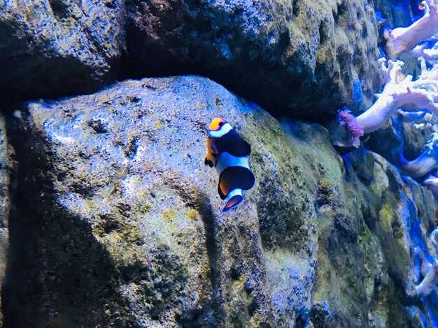
Cenotes: selecting by cave type, depth, and light exposure
Choose a shallow open cenote with bright daylight, a reachable wall, and calm water as your must-start option for the first visit. This setup works well for people, including families, and their reaction is often positive when exits are direct and the surface is visible from below. If the water feels cold at the surface, slip on a light wetsuit and take a gradual approach before moving deeper later.
Three cave type families shape your day: open cenotes that flood with sun, semi-open sites with a partial roof, and cavern routes where light fades and walls tighten. Each type is different: open sites reveal corals and clear lines on the wall, semi-open spaces balance shade and color, and cavern paths reward meticulous navigation along a guided route. Their features help you pick the right setting for activities and comfort, and others in your group can join at their own pace.
Depth matters. Shallow zones below 8 m ease learners into buoyancy and signaling, mid-depth ranges 8–20 m reveal larger walls and more life, while deeper pockets 20–40 m demand meticulous planning, a certified guide, and sign-up prior to entry through the site’s safety system. Always confirm the depth at the entrance and stay within your training level.
Light exposure defines mood and color. Bright sun near openings creates vivid outlines, while deeper or shaded sections show a cooler, blue-green glow that changes how corals and formations appear. Plan to visit around mid-morning or late afternoon to balance light, shadows, and visibility; this helps photographers and casual visitors alike, again for a different lighting effect.
Book with a reputable operator; sign-up ensures a structured day with a direct briefing, a safety system, and clear limits on depth and exposure. In addition to cenote time, you can add surface activities and nearby reefs or reef encounters; around the yucatan coast, including holbox and other spots along the caribbean coast, these options broaden the experience and increase the chances to see sharks when seasonal conditions permit. This balanced approach provides something for every person and keeps the pace comfortable for families and first-timers.
Examples you might consider: Dos Ojos offers extensive passages through cavern and open sections; Gran Cenote presents clear water with bright surface, and Ik Kil delivers a dramatic deep shaft. These sites show how depth and light interplay; here on the peninsula you’ll find people who went for a variety of experiences, including visitors from around, and others who want to focus on mindful exploration among the reefs and cenote walls.
Seasonal visibility and water conditions by month
Plan February through April for the clearest sea visibility and comfortable temperatures. Expect calmer mornings and steady currents near reef edges, ideal for multiple excursions along the Riviera Maya and Cozumel region.
- January
- Visibility: 15–25 m
- Temperature: 25–27°C
- Current and winds: light to moderate; NE winds in the morning
- Notes: reef edges stay clear on most days; shallow zones show excellent visibility
- February
- Visibility: 18–30 m
- Temperature: 25–28°C
- Current and winds: light to moderate; mornings are usually calm
- Notes: east-facing reefs often display sharp clarity; stable days near offshore sites
- March
- Visibility: 25–35 m
- Temperature: 26–29°C
- Current and winds: generally mild; best results after sunrise
- Notes: optimal windows along Cozumel and the reef corridor
- April
- Visibility: 28–40 m
- Temperature: 26–29°C
- Current and winds: stable; dry spell supports long, clear windows
- Notes: near-shore zones stay clean; schedule early slots for the best light
- May
- Visibility: 20–32 m
- Temperature: 27–30°C
- Current and winds: breeze increases; brief showers possible
- Notes: turbidity can rise after rain; mornings are ideal
- June
- Visibility: 18–28 m
- Temperature: 28–30°C
- Current and winds: winds pick up; seas can be choppier on exposed sites
- Notes: flexibility helps; check forecasts for offshore routes
- July
- Visibility: 15–25 m
- Temperature: 28–31°C
- Current and winds: humidity high; showers frequent
- Notes: morning windows improve clarity; offshore reefs remain productive
- August
- Visibility: 15–25 m
- Temperature: 29–31°C
- Current and winds: warm, often breezy; storm risk rises
- Notes: plan with a flexible schedule; some days offer excellent clarity
- September
- Visibility: 15–25 m
- Temperature: 29–30°C
- Current and winds: rainy season in full swing; turbidity after rain spikes
- Notes: cenotes stay reliable; choose mornings after dry spells
- October
- Visibility: 20–30 m
- Temperature: 28–30°C
- Current and winds: post-storm stabilization; mornings are clearer
- Notes: early planning helps, especially for offshore routes
- November
- Visibility: 25–35 m
- Temperature: 26–28°C
- Current and winds: dry-season pattern begins; winds moderate
- Notes: the region shows strong clarity; nearshore shelves offer stable conditions
- December
- Visibility: 20–40 m
- Temperature: 25–27°C
- Current and winds: north swells possible; mornings often calmer
- Notes: end-of-year slots yield excellent light and long sightlines
Cenotes offer reliable clarity year-round; temperatures stay in the mid-20s °C, with mornings delivering the best light through skylights for photography.
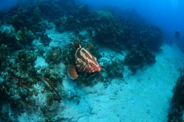
Currents, depths, and safety planning for reef and drift dives
Book a guided, licensed drift session with a local operator who provides a surface marker buoy, reel, and a clear exit plan. Ensure a meticulous safety briefing, check current forecasts, and confirm exit options before entering the water. If winter here brings cooler water, wear a 3–5 mm wetsuit and stay ready to adjust pace; most drift routes around the Yucatán deliver a bucket-list moment when you move with the healthy balance of current and buoyancy, creating a memorable encounter with the natural world and its species. The oceans can be calm yet demanding, so prepare five core steps to stay ready and safe.
-
Currents, angles, and site selection – In this region, surface flows are driven by trade winds and tidal exchange. Most reef lanes run 0.5–1.5 knots on calm days; in calmer morning windows you gain a little more control, while afternoons can bring stronger push toward the back reef. Look for controlled entry points and exit options that align with your plan, such as channels that offer predictable paths back to the shore. Keep an eye on olhos–the eyes of the reef area seen by guides–as indicators of activity and visibility shifts; if the water looks green and murky, slow and reassess. Always have a plan for back-up exits and avoid routes with sharp cross-currents.
-
Depths and bottom time – Typical reef sections stay around 12–18 m, with some wall zones dropping to 20–25 m. For drift-lane safety, plan a bottom time of 25–40 minutes in calm conditions, then add a 3–5 minute safety stop at 5 m. If current accelerates, shorten bottom time accordingly and ascend earlier to maintain a second safety margin. Average gas reserves should be checked against the planned time and depth, aiming to finish the session with a comfortable reserve.
-
Five essential safety checks – Use a short, meticulous checklist before every session:
- Forecast and currents: verify the latest update and confirm that exit routes remain viable.
- Equipment readiness: SMB/reel, whistle, knife, spare gas if available, and a buoyant belt; confirm buddy signals.
- Buoyancy and trim: practice a light, controlled glide with minimal fin work to reduce impact on the water column.
- Site plan and angles: agree on a primary route, back-up exit, and contact points for the team.
- Gas management: ensure reserve, plan the second stage of the mix, and pace work to avoid early depletion.
-
Safety equipment and communication – Carry a surface marker buoy, signal whistle, and a cutting tool; a reel helps you manage drift when currents shift. Communicate with your buddy using agreed hand signals and maintain visual contact as you approach potential narrowing points or silt zones. On calmer days, you may explore closer to green slopes; on stronger days, stay nearer to the exit and maintain a steady rhythm to keep the group balanced.
-
Environmental awareness and site-focused choices – Respect marine life and keep distance from critical habitats. Choose routes where you can observe natural behavior without interfering with wildlife, such as reef crevices or shallow ledges where species like parrotfish and angelfish commonly move. Note how the current shapes your path across the kelp-like greens and sandy patches; plan options that minimize contact with fragile coral and maximize opportunities to observe small natural acts, such as fish schooling and shell activity.
Posterior planning concentrates on safe margins and realistic options, not on pushing limits. A well-chosen route reduces stress on your second stage and supports a healthy balance between exploration and safety. Remember: most memorable moments come from calm, controlled movements, thoughtful angles, and a strong, cooperative team–here in the Yucatán’s tropical oceans, where winter temperatures trend toward the mid-20s Celsius and the game is to stay ready, meticulous, and mindful of the planet we share with countless species.
Gear and safety checklist for Quintana Roo dives
Perform a thorough pre-entry gear check on the beach at least 30 minutes before any underwater outing. Verify regulator and first stage, alternate air source, buoyancy control device, weights, and computer are within specification, and confirm a charged backup light and spare batteries are stowed in a dry bag.
Carry a redundant air source, a bright primary light, spare mask strap, and a safety reel or line for cenotes or reef sections. There should be a clear plan with your buddy for contact if visibility drops or currents shift.
Depths awareness matters: Open Water certification typically limits to 18 m (60 ft). For deeper options, complete Deep or Tec training and accompany a qualified guide. In cenotes, plan your maximum according to experience and follow your guide’s instructions. Request an in-depth briefing before entering any zone.
Wildlife and environment: Caribbean reefs host turtles and eagle rays; keep distance and do not chase. Caribbean reef life is worshipped by locals and divers; observe from a respectful distance.
Protection practices: Use reef-safe sunscreen on shore, avoid applying near the waterline, and protect beach and reef by staying on established paths and not touching corals. Bring a small bag for trash and a reusable bottle to reduce waste.
Options for gear and access: Quintana Roo offers rental gear and guided trips; playa del Carmen and nearby playa areas have shops. There are other options, including shops at the coast and in Cozumel. If you drive, start early to miss traffic and have more time to check equipment. There should be time for a last-minute check as you arrive.
Emergency planning and trusted sources: carry a surface signaling device, know local emergency numbers, and have a plan to exit quickly if conditions deteriorate. Источник of best practices sits with years of experience shared by local contributor; having been active for years, these contributors guide new divers and then help you explore the Caribbean with confidence. Knowledge from experienced guides can allow safer decisions and then help you enjoy the scene.