

 Boating Navigation – Essential Tips & Tools for Safe, Confident Cruising">

Začnite každú cestu zoznamom kontrolných bodov pred odchodom.aktualizujte grafy, overte známe riziká, nastavte trasy a potvrďte údaje o počasí a prílive. Počas príprav zabezpečte, aby bol čas posádky venovaný jednému, štruktúrovanému režimu. To znižuje neočakávané udalosti na poslednú chvíľu a pomáha prijímať aktualizácie do 10 minút, ak sa podmienky zmenia.
Tradičný skills blend with modern systems. Používajte kompasové kontroly spolu s elektronickými plánmi a AIS. zobraziť situácia nad vodou a pod ňou, asistujúcim pri navigácii v rušných kanáloch. Udržiavajte neustálu bezpečnostnú kontrolu: skontrolujte hasiace prístroje, záchranné vesty a signalizačné zariadenia.
Poznámky k prístavným postupom: udržiavajte konzervatívnu rýchlosť v preplnených kanáloch (6–8 uzlov), dodržiavajte osvedčené trasy a keeping voľné od frekventovaných trás. Po každom príchode do prístavu vykonajte rýchlu kontrolu trvajúcu 2 minúty, potom pokračujte v plánovaní s novými údajmi.
Počas ciest v blízkosti zelená markery, overte báze podľa známych orientačných bodov, plynutie času a meranie accuracy proti prílivovým tabuľkám. V bavorskom riekovom korite sa prispôsobujte úzkym kanálom a silnejšiemu prúdu.
Zdieľajte plánovacie dáta s posádkou, zaznamenávajte notes odklonení a aktualizovať záznamy po každej zmene. V prípade náhleho situation, spustiť alarm, prepnúť na záložný systems, a držte time v mysli.
Plavba a navigácia: Navigácia magnetickým kompasom – Praktické tipy a nástroje pre bezpečnú a sebavedomú plavbu
RecommendationNainštalujte robustný magnetický kompas s jasným rámikom, umiestnite ho na chránené, bez rušenia miesto a majte na palube záložný offline kompas. Počas plavby pod plachtami skontrolujte kompasový kurz v porovnaní s orientačnými bodmi a mapou, čím vytvoríte spoľahlivý zdroj pravdy aj v prípade zlyhania elektroniky.
Ako čítať ložiskáUrčite nadolím tým, že zamierite na pevný bod a odčítate azimut z očnica; potom upravte podľa aktuálnej deklinácie a, ak je to potrebné, odchýlky z vlastného systému plavidla. Zapíšte stupne, minúty a sekundy ako skratky do terénneho zápisníka a tiež si všimnite niečo ako S, J, Z, SZ pre rýchlu referenciu. Určité kroky znižujú chybu za veterných podmienok.
Používajte orientačné body po trase na potvrdenie vypočítaného smeru; tiež majte na pamäti, že rýchle zmeny vetra alebo nárazy môžu loď odkloniť od čistého magnetického smeru. Ako záložný systém používajte pevné body na brehu, ktoré sú viditeľné z prístavov a známe z plánovacích map. Kombinácia napájanej kompasu a nezávislého zdroja informácií vás udrží v správnom smere aj v prípade zlyhania GPS.
Kontrolné vybaveniaUistite sa, že kompas je vybavený a nainštalovaný s riadnym upevnením, skontrolujte káble alebo zapojenie, ak je súčasťou rozsiahlejšieho systému; majte pripravenú záložnú batériu, aby nástroj zostal funkčný, keď vypadne hlavné napájanie. Nainštalujte druhé zariadenie ako rýchlu zálohu a označte miesto inštalácie oznámením pre zmeny posádky. Pozrite si prístavy pre oznámenia o magnetických interferenciách blízko prístavných napájacích káblov; bavaria poskytuje miestne usmernenie od úradov; používajte ich ako jediný zdroj pravdy.
Plánujte a precvičujtePri vytváraní plánov si zaznamenajte oblasť a potenciálne miesta s magnetickými interferenciami (v blízkosti napájacích káblov, motorov alebo záťaží). V ekonomických podmienkach noste kompaktnú laminovanú mapu magnetickej variácie podľa oblasti. Loďari by mali striedať magnetický smer a skutočný kurz na mape, aby sa predišlo odplávaniu. Nasledujúci zvyk zlepšuje sebadôveru, najmä v noci alebo v hmle.
NoticeSledujte kábely motora a elektrické vedenia, aby ste predišli rušeniu; udržujte oblasť okolo kompasu bez feromagnetických objektov, vyhýbajte sa kovovým prevodom a udržujte prenosné zariadenia ďalej od kompasu; dodržiavajte približnú vzdialenosť v nohách od zdroja, ktorý môže deformovať odčítania. Nebezpečenstvo požiaru v blízkosti palivových vedení si vyžaduje rýchlu reakciu a odstránenie, ak iskru spôsobí závan. Jachtári v prístave by mali používať prevádzku jedného motora, keď sa spoliehajú na magnetické smerovanie; ak zaznamenáte odchýlku, skontrolujte znova s mapou a upravte podľa požiadaviek úradov.
Offline operácia zostáva praktické pri dlhých prejazdoch; to je v súlade s vlastníctvom a systémovým prístupom, čím sa zvyšuje odolnosť, keď zlyhajú napájanie alebo elektronika. Techniku je možné testovať v rôznych podmienkach oblasti; bavorské pobrežie ponúka kopce, ktoré menia priamu viditeľnosť na orientačné body, takže sa na tieto orientačné body spoliehajte na overenie smerov. Udržujte si jedinú, hospodárnu súpravu, ktorá obsahuje náhradnú batériu, laminovanú terénnu kartu s skratkami a jasné plány na prepínanie medzi magnetickým smerom a zakreslenými kurzmi.
Magnetická kompasová navigácia: Základné postupy pre bezpečnú a sebavedomú plavbu
Vždy nastavte magnetický smer k vašej plánovanej trase pred odletom., potom overte pomocou ďalšej metódy, napríklad GPS alebo orientačných bodov. Udržiavateľ vám tak zaručí, že ste na správnej trati aj vo vodách ovládaných prúdy a zmenami smeru vetra, čo vám umožní plaviť sa s väčšou istotou.
Regular learning a following štruktúrované class pomáha stavať awareness of rozdielnosti med merania kompasu a skutočnoučipřskou smerovoučpodobou. Pouſite offline practice na posilnenie svalovej pamäti: pohybujte kompasom, porovnávajte údaje s mapovými údajmi a zaznamenávajte si poznámky do vášho ownership notes.
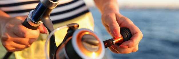
Udržujte ručné a stacionárne prístroje v serviceskontrolujte praskliny, vymeňte rámček a uistite sa, že nabitie je adekvátne pre záložné zariadenia. Keď cesty zahŕňajú fishing alebo sa blížiac around shoals, use the bearing to steer a secure oblouk a periodicky skontrolujte.
Pltníci by si mali uvedomiť, že many faktory ovplyvňujú výsledok: lokálna variabilita, rozdielnosti med mapou a displejom a vplyvom kovových predmetov. Vždy majte data from multiple means s ohľadom a spoločne rozvíjajte robustný návyk, aby ste zostali na správnej ceste.
Praktický postup: skontrolujte smer, potom ho znova skontrolujte po zákrute alebo zmene vody, prúdov alebo vetra; veďte si záznamy, prehodnocujte. awareness data after each tripa include notes on how technológia a products performed offline and online.
Pre-Departure Compass Check: Declination, Deviation, and Swing
Set your magnetic compass to the latest declination from the updated chart or источник on deck, then lock the setting. Cross-check with the deviation table to ensure the numbers reflect current waterways, and log the change in a quick table aboard to support your plans and trips. Document the detail of the adjustment to aid crew work during pre-departure checks.
Compute the true heading by applying two corrections to the observed compass heading: deviation (D) from the vessel’s deviation table, and variation (V) from the chart. Use the equation TC = CH + D + V, with signs taken from the sources. Example: CH 090°, D = +2°, V = +5° yields TC 097°. When D or V are negative, adjust accordingly to keep your plotting on the intended type of course.
Perform a swing check while berthed: rotate the wheel through 360 degrees and compare the compass reading with a fixed reference bearing from landmarks or a charted line on the plotter. Note what you observe, expect swing to stay within roughly 0–6° on a typical hull; larger swing indicates residual magnetism or nearby damage. If you detect excess swing, pause, reassess deviation data, and rely on a quick, powered backup such as GPS overlay to confirm the route while you adapt.
If the hull or compass shows damage, or interference from gear is suspected, rely on a gyro compass or GPS-based track as a stand-in. When youre plotting trips through channels, a lake passage, or long waterway legs, keep a stand-on bearing in mind and enable a quick cross-check with the GPS plot to stay carefree and on plan.
Document the updated data in a dedicated table on deck, mark источник as the data source, and share the results with everyone aboard, including the charter crew. This detail keeps your plans aligned, reduces risk during long trips, and enables carefree travel between water channels.
Reading the Compass at the Helm: Navigating with Pitch, Roll, and Spray
Lock the helm and confirm a stable bearing by aligning a magnetic compass with sense4boat data, and use aids such as a gyro or fluxgate to cross-check readings; verify signal quality via hdop readouts, which is more accurate than a single instrument. If the numbers drift beyond ±3 degrees after a 15-second check, then re-center and re-check against the tide.
On deck, shifting seas produce spray that fogs the compass card. Keep your gaze through the binnacle, practicing calm helm corrections, and react quickly to small deviations; blasts from waves can push readings off, so strive to adjust before another span passes. This reduces collisions, a clear advantage in distress situations. Stay mindful of regulations.
Bilge pump readiness matters; ensure lines are clear and checks don’t interfere with cockpit instruments.
Learning updates from a network of owners, Bavaria sail owners, and suppliers of products keep you informed. Sense4boat readings, hdop trends, and numbers flux matter more than a single instrument. Informed care stays steady; you become more capable as conditions change through dives, tide, blasts, and gusts, and the approach can feel carefree yet precise. This significantly sharpens decision making.
| Condition | Action | Poznámky |
|---|---|---|
| Pitch > 5° or roll > 6° | Return to bearing; recenter; cross-check hdop | Cross-check with sense4boat; then lock |
| Spray obscures readout | Recenter; adjust to keep readings aligned | Keep eyes on cards; monitor spots |
| Reading drifts on spots | Record numbers; compare with network updates | Become consistent; updates help |
Correct for Variation and Deviation in Real-Time Bearings
Always validate bearings in real time by cross-checking magnetic readings with GPS positions and known visual cues, including buoys and upstream references to confirm alignment with the intended course.
- Baseline setup: pull local variation from a current chart or offline apps, then set that value in your compass settings and the electronics display, creating a single reference used in quick checks.
- Continuous cross-check: maintain alignment between magnetic bearing and GPS-derived course; compare positions against marina charts and a few fixed marks; when a discrepancy is detected, adjust bearing values immediately and log changes with concise abbreviations.
- Crew responsibilities: assign a quick observer to watch visual cues and buoys; keep the crew informed, involve your electrician when hardware readouts drift, and ensure the log is updated with care.
- Interference and drift: be mindful of blasts from nearby equipment or power lines that can shift readings; recalibrate, verify compass alignment, and test against a known set of courses to restore accuracy.
- Offline resilience: if connectivity or apps go offline, rely on positions, visual cues, and a trusted set of tracks; maintain a small record of bearings, positions, and courses to speed real-time decisions.
- Maintenance discipline: keep electronics well maintained, replace batteries, and review settings regularly; theres a need to verify readings after any calibration, and the crew should review the log after every trip; involve your electrician for a hardware check.
- Reference tools: use marina charts, buoys, and equipment to confirm alignment; with many inputs, accuracy improves; always align your heading with a good visual reference and a backup from apps or GPS.
Cross-Check Bearings with Charts, GPS, and Visible Landmarks
Check bearings against three sources: charts, GPS, visible landmarks before every leg. In practice, run the three-source check to confirm your position within the area, then update as you move. This approach increases accuracy when approaching busy zones such as wakeboarding zones, and when dealing with depths that change with tides.
- Charts and abbreviations: Read the fundamental bearing shown on the chart. Use the chart source; verify scale, grid, declination, and abbreviations in the legend. Note depths in the area and record what you see in your log tables to reference later.
- GPS and sensors: Compare GPS bearing with chart bearing; check sensor status, time, and update rate. If readings diverge beyond a small margin, switch to dead reckoning and relying on landmarks until readings align. Set an alarm if drift persists beyond 2–3 minutes.
- Visible landmarks: Identify at least two fixed features on shore or buoys; take visual bearings to each, compare with chart positions, and verify your location every few minutes. This critical step helps when GPS is degraded or signal is limited.
- Handling discrepancies: If misalignment exceeds a preset threshold, execute a rapid cross-check using what you know about depths and the ship’s wake. Update course gradually to reestablish your path.
- Record keeping: Save information in a dedicated log; include time, location, measured bearings, and notes. Refer to books or class materials, and fill in tables with abbreviations you can glance quickly. This ensures everything is captured.
- Practical practicing: Before class or during drills, run this routine on a known journey route. Practicing increases tolerance to misalignment as you sail near zones and other craft. What you learn here becomes baseline behavior when sailing in unsettled conditions. This practice will increase your accuracy.
Maintaining the Compass: Cleaning, Storage, and Magnetization Prevention
Start with a clean, magnetically neutral base: wipe the compass face with a soft microfiber cloth, rinse with fresh water, and dry thoroughly. Use a mild soap if needed; avoid solvents. Keep the unit above the deck to minimize moisture ingress and prevent water marks on the glass. After cleaning, verify the north reference against a distant mark or marks on a chart, confirming accuracy before heading out on the journey.
Maintain proper storage: when not in use, place the compass in a dry, cool container away from ferrous hardware, high-current cables, and any electronic sensors that could induce stray fields. The goal is to keep the dial balanced; avoid exposure to ferrous metals that can magnetize the dial. Store with the face up to help back bearings and maintain readability.
Magnetization prevention: keep the instrument away from beidou antennas and other magnet sources around the cockpit; a single magnet can cause drift, producing multipath-like errors when plotting routes. If you notice drift, perform a simple calibration against a known north reference. This must be part of your awareness at all times.
Simple checks during plotting: use sense4boat to compare compass output with GPS sensors; taking updates from authorities when away from shore; stay aware of distances and routes to limit collisions. If sensors show a discrepancy, develop understanding that a great deal of external influence can upset readings and adjust accordingly.
Charter crews, especially in bavaria, must stay aware of a routine that keeps the compass reliable. Start each day by checking alignment, and stay prepared with a back-up bearing. The aim is a carefree journey with reliable bearings, while authorities oversee safety and distances to other vessels along busy routes.
Regular checks create awareness of multipath and external interference that sensors may reveal. Building understanding of how external factors affect readings helps you stay able to plot more accurately. A simple, repeatable routine–clean, store, magnetization precautions–keeps distances and routes accurate, making back-up bearings usable when conditions are rough. Stay mindful of authorities and be proactive in maintaining performance on the journey ahead.