

 5 Najlepších pláží v Neapole na objavenie loďou">

Začnite svoju cestu s Positano ako prvá časť a prenajmite si ľahkú loď pre obežné plavby od svitania do súmraku, ktorá obchádza zálivy s útesmi a morové oblúky, pričom sa vyhýba vrcholiacom horúčavám a davom. Prineste si prenosné stoličky na pokojný obed na palube, zatiaľ čo vôňa citrónovníkových hájov a morskej peny povzbudzuje zmysly.
Od toho sa vydajte smerom na Capri a jeho ikonické scenérie, vrátane vertikálnych útesov, borovicami posiatych terás a underground grottoes, ktoré žiarivú, keď slnečné lúče prenikajú vodou. Znalosť skúseného jamníka vám pomôže načasovať návštevy oblúkov a jaskýň, zatiaľ čo posádka môže cater Pre chut' na pobrežie a nápoje podľa vlastného výberu. Zaujatosť Capri spočíva v dramatickej scenérii a intímnych zálivoch. Vzdialenosti sa líšia v závislosti od vetra, zvyčajne 45–90 minút z Positana v závislosti od podmienok, čo umožňuje jednodňový výlet.
Next, Ischia–tá bujná oblasť oproti pevnine–ponúka sopkovú oblasť, termálne pramene a záhrady, ktoré orámujú obzor. Tu môžete zakotviť neďaleko malých villages kde čas spomaľuje, pohľadnite na zvyšky storočných obchodných trás a vychutnajte si čerstvý obed na palube. Trajekt zo Capri do Ischie trvá 60–90 minút motorom a... last Cesta loďou do Procidy môže trvať podobný čas, v závislosti od vĺn.
Procida presents a different flavor: bright facades, a quiet harbor, and coastal lanes that thread past relics and overlook the Campania coast. To ensure you get the exact views you want, submit a request vopred vášmu skiprovi, aby sme mohli zabrániť meškajte a prispôsobte kotvy zákrytom a západu slnka. Urobte si to sami a nechajte posádku. cater Premeňte deň podľa svojho tempa, sústreďte sa na pobrežnú scenériu ostrova, bujné cesty a dedinky, ktoré sú posiate pobrežím Kampánie.
Pláže Neapola prístupné loďou: Výber a prístup
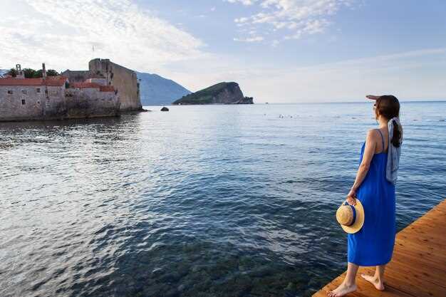
Začnite pokojným ranným prístavom pri Marina di Puolo, Massa Lubrense, a nastavte si celodenný program s licenciovaným kapitánom a malým záchranárskym člnom. Sprievodcovská námorná prehliadka vám umožní dosiahnuť odľahlé zátoky pozdĺž juhozápadného pobrežia, zachytiť jemné vlny a ponoriť sa do scenérie, kým sa uvoľníte na palube. Spoliehajte sa na sprievodcov pre príliv, prúdy a bezpečné trasy.
Cala di Puolo (Massa Lubrense) ponúka plytkú, čistú vodu ideálnu na šnorchlovanie, keď sú prúdy priaznivé. Ak zakotvíte blízko pláže, môžete vypustiť skúter na prieskum skalnatých zálivov; po prípadnom doplomovaní vám miestni ponúkajú čerstvé morské plody a limoncello v malých obchodíkoch.
V Praiano, v chránenej zátoke a súkromnom prístupovom bode na... La Gavitella pláž odmeňuje potápačov pokojným morom a západmi slnka. Krátka, priamočasná kotva vám umožňuje skočiť do reštaurácií na útese; po oddychu si môžete požičať skúter, prechádzať sa po domoch a ponoriť sa do veľmi uvoľnenej rytmy dedinského života, s poznatkami od miestnych.
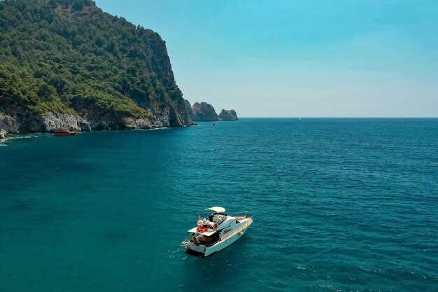
Capriho Marina Grande a blízke zátoky ponúkajú luxusný rytmus, s flotilou plavidiel, ktoré zabezpečujú súkromné prehliadky a palubové služby. Na šnorchlovanie si môžete prezrieť podmorskú jaskyňu okolo Capri, pričom sprievodcovia vysvetľujú prúdy a sezónne podmienky; pripravte sa na veľmi malebnú plavbu so dramatickými útesmi a tyrkysovou vodou.
Dohodnite sa s miestnymi obyvateľmi a renomovanou agentúrou, ktorá ponúka kompletnú bezpečnostnú výbavu, podmorské mapy a flotilu záchranných člnov. Navštívte obchody pozdĺž pobrežia pre chutné morské plody a limoncello, pýtajte sa na domy na prenocovanie a získajte informácie od obyvateľov, ktorí udržiavajú túto námornú trasu nažive, pričom si užijete luxusný deň na vode.
Ktoré pláže v Neapole sú dostupné loďou z prístavu?
Odporúčanie: Začnite s Marontami na Ischie; nedotknuteľné pobrežie sa nachádza pozdĺž dlhého oblúka a je ľahko dostupné z prístavu vodiacimi prostriedkami. Nastavuje živé tempo tyrrhenského dňa a predstavuje prístupný prvý bod zastavenia, ktorý splní váš cieľ.
Ďalej naplánujte okruh do Baia di Ieranto pri Massa Lubrense pre odľahlú zátoku, ktorá zostáva obľúbenou u miestnych obyvateľov. Prístup portus je priamy a krátka loďka vás vysadí na kamenistú pláž, kde je zjavné oddanie morského života v rytmoch dediny. Pozorovanie od miestnych rybárov zdôrazňuje mozaiky svetla na vode južného pobrežia Kampánie – scéna zostáva dostatočne pokojná na rýchle kúpanie alebo bagno pred pokračovaním.
Cala di Puolo, leno hops od Massa Lubrense, ponúka útulnú calu pri pracujúcej rybárskej dedine. Loď ťa môže vysadiť blízko bagno a prechádzka do blízkeho námestia, kde mozaiky zdobia steny. Prostredie je chránené, vhodné pre rodiny, s jemnými prúdmi pre bezpečné ponorenie.
Capriho La Fontelina je klasická zastávka během dne; flotila lodí z přístavu vás doveze do chráněné kalové zátoky s tyrkysovou vodou a panoramatickým výhledem na útesy. Místo se vyznačuje nadčasovou oddaností námořní kultuře a často nabízí ideální podmínky pro krátké šnorchlování před pokračováním v okruhu.
Procida’s La Chiaia uzatvára okruh: dlhší presun na južný ostrov ponúka uvoľnenú atmosféru dediny a plytkú, chránenú brehovú oblasť La Chiaia. Táto zátoka zostáva nenáročná, s bagni (kúpaliskami), jednoduchými reštauráciami a dotykom mozaík v oblasti prístavu, ktoré odrážajú súčasné čaro ostrova na pobreží Kampánie.
| Spot | Area | Účast prostredníctvom súťaže | Distance (nm) | Highlights | Poznámky |
|---|---|---|---|---|---|
| Maronti (Ischia) | Ischia | Áno (prístavište neďaleko Ischia Porto; záchytná služba na breh) | 18–22 | nedotknutelné pobrežie; dlhá oblúka; vhodné pre rodiny | najlepší v ranných hodinách; dostupné prístavy portus |
| Zátoka Ieranto | Massa Lubrense | Áno (malý prístav, kamenistá breha) | 15–18 | samotár; smaragdovo zelená voda; útesom orámované | watch westerlies; bagno on shore |
| Cala di Puolo | Massa Lubrense | Áno (brehová oblasť pri obci) | 16–20 | príjemná cala; atmosféra rybárskej dedinky | priedstavivé prílivé skaly; prÿijemná prechádzka k blÿrþj časti. |
| La Fontelina (Capri) | Capri | Áno (v prístave alebo blízko pobrežia) | 20–24 | ikonická tyrkysová cala; prístup do plážového klubu | rezervujte si miesto na obed v bagno |
| La Chiaia (Procida) | Procida | Yes (near port; tender to shore) | 22–28 | relaxed village atmosphere; calm bay | evening light ideal for photos |
Launch points, marinas, and docking options around Naples
Begin at Tin City’s City Dock for an excursion-ready start; this launch point sits on the Gordon River and grants fast access to backwater creeks and mangrove tunnels, with a short walk to fuel and waterfront dining. This spot is among the area’s most practical for quick, shallow-draft routes that align with daytime trips. From here, excursions push toward Caxambas Pass and the Ten Thousand Islands, this makes it easy to keep the heart of your plan centered on water.
Public ramps include the Cocohatchee River access and the Delnor-Wiggins Pass ramp; both located along the coastline and serving mid-size watercraft. Facilities offer parking and restrooms; expect calm mornings and occasional surf on wilder days.
Premier marinas: Tin City City Dock (downtown waterfront) provides transient slips, pump-out, fuel, and dockside stores; Port of the Islands Marina on Marco Island offers slips, electricity, fuel, and on-site provisioning; Marco Island Marina presents full services and guest slips with a nearby market.
Docking options include short-term slips, mooring buoys, and seasonal leases; book ahead during peak season, and verify arrival windows with the harbor master.
Snorkeling choices include immersive guided excursions to reef pockets along nearshore shoals; operators rent gear and offer family-friendly trips, with sunset cruises that appeal to different interests.
Insider tip: talk with harbor staff; locals speak about the roots of the waterway and the century-old maritime culture. If you’re looking for a casual bite afterward, gennaros and julius stand out, with limoncello and regional dishes. mexico influences show in hospitality and menus, while the heart of floridas coast remains welcoming; bathhouses nearby offer a quick rinse before heading back.
Gear, packing, and daily essentials for a Naples boat day
Start with a dellovo dry bag system and sunscreen at SPF 50+. For a half-day plan, keep gear lean and divide into three zones: personal care, crew comfort, and navigation safety. In naples harbor area, a clear route makes groups easier to manage and lets you relax later in the day. If youre with a local fleet of vessels, coordinate times to share space near the port.
- Dry bags: dellovo 20–30 L per person to keep phones, keys, and towels dry.
- Sunscreen: broad-spectrum SPF 50+ with water resistance; reapply every two hours.
- Hats, UV shirt, and polarized sunglasses to cut glare off waves.
- Hydration: at least 2 L per person, plus electrolyte packets.
- Snacks: energy bars, nuts, and dried fruit for a quick boost.
- Footwear: water shoes or quick-dry sandals; pack a spare pair.
- Resting chair: a compact foldable seat for long stretches; a light blanket helps in shade.
- Safety and signaling: whistle, compact flashlight, and a basic first-aid kit.
- Valuables protection: waterproof case for phone and camera; spare battery bank.
- Navigation and planning: map or offline GPS; share the plan with someone on land-based contact.
- Beach towels and a small towel for drying after underwater activities.
Safety and comfort: distribute weight evenly on the craft to keep stability; keep decks clean and dry; store valuables in dry bags when entering the water. If youre traveling with three groups, designate a lead guide; two guides were ready to coordinate gear, snacks, and safety checks. Guides and services can tailor a half-day schedule that feels unrushed and captivating, with a dazzling coastline to enjoy and breathtaking views from the harbor mouth.
Practical routine: check tides and wind direction before departure; choose sheltered coves if waves pick up. Keep a land-based contact for updates, and return to a port early enough to rinse gear and switch to dry clothes. When you finish, rinse equipment near a shore facility and store in dry bags to keep the gear ready for the next adventure. The feel of a calm, well-planned trip often turns an ordinary afternoon into a memory that remains in your neighborhood for years.
Safety rules, permissions, and environmental guidelines for boating near beaches
Obtain clearance from the harbormaster before departure and share your float plan with a trusted person. Times, tides, and weather can shift quickly; below is a concise safety and stewardship checklist for the naples peninsula to protect people, wildlife, and sites.
- Safety gear and signaling: every person on board wears a properly sized PFD; have a throwable device accessible; carry a whistle, flashlight, and VHF radio on channel 16; read and follow the safety symbols on gear and equipment labels.
- Permits and permissions: verify anchoring or mooring with the marina service desk or port authority; obtain any licenses required for restricted zones near the peninsula; for Maronti spot access, secure explicit permission before approaching or tying to mooring buoys; when unsure, prefer guided services from licensed operators.
- Environmental stewardship: maintain a slow speed and minimal wake to protect shoreline and wildlife; avoid seagrass meadows (Posidonia oceanica) and other fragile habitats; do not touch underwater relics or submerged archaeological sites; respect historical lore and coastal secrets, and keep hands and gear clear of sensitive bottoms; adhere to extensive regulations to preserve the area’s character.
- Waste management and fueling: carry all trash back to port and use pump-out facilities for sewage; no discharge of bilge or gray water within 100 m of shore; refuel at designated stations and keep spills contained with absorbents; never dispose of oil or chemicals in the water.
- Anchoring and navigation: use designated mooring buoys when available; anchor only in sandy bottoms away from seagrass meadows and protected zones; maintain a safe distance from swimmers, surf, and other craft; avoid leaving the vessel unattended in the surf zone.
- Wildlife protection and heritage: observe birds and marine mammals from a distance; do not harass or feed wildlife; if you encounter underwater relics or submerged ruins, do not touch and report to authorities found below the surface; preserve the historical fabric of coastal cities along naples gulf and beyond.
- Communication and emergency planning: monitor weather forecasts and tide times; plot a route that allows a quick escape to a sheltered spot if conditions worsen; in danger, dial 112 or use VHF channel 16 and signal with flares if needed.
naples area offers extensive opportunities to enjoy Maronti and other coastal spots with a thoughtful approach. Start early, follow the original route that respects shoreline rhythms, and rely on world-class marina service for guidance. Though it requires discipline, this choice yields an immersive experience with rich, historical lore and safe, responsible enjoyment for people on board and those living in nearby cities, while preserving the sandy shores for future visitors.
Top 5 nearby beaches: quick-access notes and highlights
Begin with Cala di Puolo for a half-day splash: paid parking along the road, a calm swimming zone, and sands that blend pebbles with soft patches. This cala sits perched above the water, with views that sweep the coastlines toward the peninsula and beyond. From the nearby piazza, send a quick note to a friend about your plan. Elena, a patron of local service, notes the devotion of fishermen here and the history that threads the harbor. Once you arrive, you feel an unforgettable moment and you wonder at the horizon, yourself immersed in sea air.
Miseno coast offers a broad sands stretch ideal for a half-day escape: paid parking nearby and a straightforward service setup–chairs, umbrellas, snack stalls. It ranks among the biggest coastlines in the area, with ancient fortifications behind the dunes adding a touch of phlegraean history. From the end of the promenade, the views sweep across blue water toward the islands, and you can spot the city lights on clear evenings.
Cala Gaiola, a sheltered cala near Pozzuoli, is the ideal stop for swimming and snorkeling. The rocky shelves drop into turquoise water, with sands washing into tiny coves that stay calm most mornings. It sits within a marine-protected zone, with a dedicated service keeping things clean and safe. Perched above the water, remnants of Roman villas whisper about history, making the visit unforgettable. From the cliff path, the views sweep across the phlegraean coastlines toward the islands.
Cala Mitigliano in Massa Lubrense offers a quieter, intimate stop: a small, guarded cove with clear water, ideal for swimming and picnics. The approach path is a short descent from the road, and the stretch of sands here invites you to linger. The scene is a reminder of the region’s enduring history, while the phlegraean backdrop adds depth to the moment.
Finish at Lido di Licola completes the circuit: a long, sandy coast with dotted rows of parasols and a mix of paid and free sections. Service options range from casual bars to beach clubs; you can rent chairs and umbrellas for a half-day, or simply stretch on the sands. The coastlines here tell a quiet history once lived by patrons and local families, and a nearby piazza is a convenient spot to send a message home. Elena would remind you to save energy for the sunset and to reflect on the wonder you felt at the horizon.