

 Best Boating Destinations on America’s West Coast">

Pentru un start solid, setează-ți course în Puget Sound din nord-vestul Pacificului, unde protejat șorăliniile și o rețea de marine facilitează învățarea ritmului croazierelor. Acest known hub oferă numeroase opportunities pent-up desires for good food and fellowship. pentru a exersa recuperarea omului căzut peste bord, selecția ancorei și deplasările scurte între porturi, toate aproape de orașe care hrănesc dorințele refulate ale unui marinar pentru mâncare bună și camaraderie. heart cu fructe de mare bune și servicii de încredere. Adaugă o notă boemă în piețele de seară și vei simți ritmul regiunii în oase. În nord-vest, această configurație funcționează bine pentru cei care vin pentru prima dată.
De acolo, pornește spre Insulele San Juan, unde diminețile tind să fie mai calme și golfurile adăpostite invită la zăbovit, în timp ce balenele și focile țin o companie liniștită de-a lungul traseului. Cunoscut sub numele de heart scenei marine din nord-vestul Pacificului american, acest grup oferă mile întregi de șoră și porturi sigure testate, atât pentru excursii de o zi, cât și pentru distanțe mai lungi. Dacă te gândești să pleci singur, alone, canalele dintre Lopez, Orcas și San Juan Island formează o rețea naturală de rute ușoare și zone de ancorare sigure.
Mergând spre sud de-a lungul coastei centrale, Golful Monterey și Insulele Channel oferă mai calm croaziere și o bogată viață marină - de la vidre de-a lungul șoră balenelor migratoare în larg. Această porțiune favorizează escalele în porturile Santa Barbara sau Santa Monica, unde planificarea din timp contează pentru diminețile cețoase. Zonele lor de ancorare sigure fac ca acest arc să fie atractiv pentru familii și căpitani care doresc, de asemenea, să testeze distanțe mai lungi și să își perfecționeze capacitatea de a aprecia vremea.
Mai spre sud, porțiunea de la zona San Simeon până la Santa Cruz și țărmurile sudice ale golfului adaugă un țărm dramatic, vânturi de larg și oportunități de a te aventura în golfuri adăpostite, înainte de a o lua din nou spre nord. Vânturile de nord-est care ating apogeul iarna și primăvara cer respect din partea navigatorilor, dar pot debloca și deplasări eficiente atunci când planifici ținând cont de maree și curenți. Pentru cele mai intense experiențe, vizează Morro Bay și Santa Barbara, apoi întoarce-te în buclă pentru a oferi echipajului tău o imagine completă a dinamicii marine și a formelor de relief pe care le vei întâlni la fiecare viraj.
Sfatul meu este să tratezi acest arc ca pe o hartă vie: învață course în zilele calme, apoi extindeți-vă spre zone mai expuse când sunteți pregătit. Rămâneți aproape de țărm pentru reaprovizionare ușoară, mențineți o vigilență strictă asupra ancorei și planificați nopți în port care permit o ușurare rapidă de schimbările meteorologice. Comunitățile lor – operatori de porturi de agrement, echipe de siguranță maritimă și brokeri locali – oferă cunoștințe solide care vă pot oferi încredere indiferent dacă navigați. alone sau cu un echipaj. heart acestui peisaj marin nu este doar apa; este, de asemenea, energia comună a pământului, a apei și a oamenilor care o cunosc cel mai bine.
De la Seattle la Insulele San Juan

Planifică o buclă de 3 zile: pornește spre nord-vest din Seattle, traversând strâmtoarea spre Insula Bainbridge, apoi spre Insula Lopez, Friday Harbor și Insula Orcas, întorcându-te prin Strâmtoarea Rosario. Acest itinerar oferă porturi cu dane private, țărmuri accesibile și activități pentru toate nivelurile de îndemânare, inclusiv verificări de crabi și navigație de-a lungul golfurilor protejate. Barbara, o skipper locală, notează abordarea: menține prova în vânt pentru andocare și folosește o aterizare puțin adâncă pentru a facilita intrarea la aterizările de seară. Peisajul terestru și marin se combină pentru a atinge inima și sufletul nord-vestului.
Plan zilnic: Ziua 1 Seattle la Bainbridge Island (10–15 nm) pentru un început ușor; Ziua 2 Bainbridge la Lopez Island (20–30 nm în total, cu opriri) și apoi Lopez la Friday Harbor (8–15 nm); Ziua 3 Friday Harbor la Orcas Island (8–12 nm) și Orcas Island înapoi la Seattle (75–95 nm). Această secvență menține traseul confortabil, cu opriri pentru activități, dane private și viraje ocazionale la stânga în porturi când vizibilitatea și vântul permit. Foarte practic este să tratezi asta ca pe un circuit flexibil, ajustând direcția în funcție de vânt și curent, pe măsură ce construiești acest itinerar. Momentele cu cocktailuri sunt ideale la apus, pe punte, după o zi de navigat.
Note practice: rezervați locuri de acostare private acolo unde este posibil, în special la Friday Harbor și Orcas; aprovizionați-vă cu echipament pentru crabi și undițe ușoare pentru verificări pe mal; planificați navigări de o zi cu distanțe moderate pentru a minimiza stresul asupra echipajului și folosiți porturi adăpostite atunci când presiunea barometrică se schimbă. Traseul favorizează diminețile calme și brizele mai puternice de după-amiază în nord-vest și veți observa forme de relief care se simt intime și memorabile, spre deosebire de porturile aglomerate găsite mai la sud, în Ventura. Aterizările în orașe mici adaugă farmec, în timp ce drumețiile pe mal și opririle pentru cafea mențin inima implicată și ziua variată.
| Leg | Distance (nm) | Recommended Activity | Note |
|---|---|---|---|
| Seattle → Insula Bainbridge | 10–15 | Început lin, apropiere de Eagle Harbor | Ape protejate; urmăriți traficul |
| Bainbridge Island → Lopez Island | 22–28 | Verificări de crab, salturi pe linia țărmului | Schimbările vântului influențează sincronizarea |
| Insula Lopez → Friday Harbor | 8–15 | Vizită în oraș, aprovizionare | Ancoraj sau loc de acostare disponibil |
| Friday Harbor → Insula Orcas | 8–12 | Acces spre Moran State Park, golfulețe liniștite | Ancoraje privat comun în zone protejate |
| Insula Orcas → Seattle | 85–100 | Traversarea Strâmtorii Rosario, întoarcere la apus | Picior lung; planifică vremea și combustibilul |
Itinerar de 3-4 zile: Seattle spre Friday Harbor
Acest itinerar începe cu o plecare privată din Seattle, la răsărit, lăsând în urmă zgomotul orașului și îndreptându-se spre Insula Bainbridge pentru un început calm și bun, care menține chila stabilă în vânturi ușoare. Călătoria oferă trei tipuri de activități: pe uscat, pe apă și la masă, cu peisaje care se simt naturale de la prova până la siaj.
-
Ziua 1 – Seattle la Insula Bainbridge (Eagle Harbor)
- Durată: 1–1,5 ore într-un ritm confortabil pe tot Puget Sound; planificați 2 ore, inclusiv acostarea și legarea parâmelor.
- Începeți această etapă din Elliott Bay, apoi aterizați la Eagle Harbor Marina; în mare parte protejat de vânturile puternice din NV.
- Primul popas bun: centrul orașului Winslow pentru o scurtă plimbare prin istorie, o cafea și o gustare lângă apă.
- Legarea privată este disponibilă; coordonați cu Barbara de la biroul portului pentru un loc de acostare și combustibil, deoarece acest port bine protejat menține fundul apei calm la maree joasă.
- Ce să faci: o plimbare scurtă pe insulă, puncte de belvedere asupra păsărilor marine și o cină la apus pe malul apei pentru a stabili direcția pentru zilele următoare.
-
Ziua 2 – Bainbridge la Insula Orcas (East Sound)
- Durată: 2–3 ore, în funcție de vânt și de viteza ambarcațiunii; luați în considerare un început la mijlocul dimineții pentru a profita de lumina naturală pe apă.
- Trasee de traversare se deschid spre Orcas, o linie naturală de cretă între continent și insulele San Juan, care oferă peisaje spectaculoase la fiecare cotitură.
- Opțiunile de ancorare includ Orcas Landing sau Doe Bay; majoritatea locurilor de acostare vă permit să mergeți pe jos până la Parcul Natural Moran și Muntele Constitution pentru o scurtă drumeție.
- History and culture stops: a quick visit to a local museum or gallery; the island offers a sense of maritime life that complements the private boating vibe.
- Land opportunities: well-marked docks, public showers, and small shops; leave the boat for a light lunch in Eastsound.
-
Day 3 – Orcas to Friday Harbor (San Juan Island)
- Times: 1–1.5 hours to Friday Harbor, a short hop that keeps everyone alert and engaged.
- Fridays Harbor Marina is a good landing point with easy access to town, the harbor nose pointing toward dining and whale-watching options.
- Activity lines: whale museum, history sites around San Juan Island National Historical Park, and a stroll along the waterfront for natural scenery and fresh seafood.
- Private charter or small-boat options offer a chance to explore nearby bays; this stop also presents an opportunity for a kayak or paddleboard session near the bottom of the harbor.
- Evening plan: dine at a harborfront bar or fish market; Barbara can suggest a dockside table with a view of the running tides.
-
Day 4 – Optional return: Friday Harbor to Seattle (or add Lopez/Orcas detour)
- Times: 3–5 hours depending on route and stopovers; consider a Lopez Island lunch if you want a longer line of sight along natural beaches.
- Direct return to Seattle avoids peak ferry times, but a three-stop looping option keeps the trip mostly dynamic and gives you extra land-time.
- Key notes: leaving Friday Harbor in the morning helps you beat afternoon winds; land at Elliott Bay by early afternoon for a smooth end to the journey.
- What you gain: a complete view of the juans’ history, culture, and scenery, plus ample private moorage opportunities and time to reflect on the three days of running.
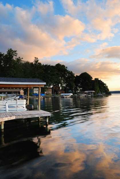
Mooring Tips and Top Harbors Along Puget Sound
Begin with Port Townsend as your first stop to lock in protection from westerlies and access to well-marked mooring fields near Point Hudson. The harbor sits behind a protective breakwater, offers calm basins, and features navigational aids that keep readers aligned with the main channel. In planning a daysail, reserve a spare hour for a quick approach drill so you’re ready if wind shifts. Mountains loom inland, but here the water stays steady enough for a comfortable first leg.
For every stop, use bow and stern lines with reliable knots, deploy fenders to fit pilings, and carry extra lines to prevent wear. Without solid chafe protection, lines wear quickly where waves wrap around contact points. Buoys mark the safe path, but always confirm their direction and current before committing. Often the strongest set appears just after slack water, so time your approach accordingly to keep control and avoid drag on gear.
Port Townsend specifics give readers a useful template: approach from the inland side of the basin, stay clear of commercial traffic, and tie into protected moorings facing the main channel with lines long enough to absorb tide swings. The nearby beaches invite a short stroll after docking, and deer sightings on the shore add a touch of adventure to a close-to-home plan. For navigational safety, deploy a reach of Buoys in the outer approach and check the fuca strait charts for any shifting currents that could disrupt a long stay.
Friday Harbor on San Juan Island features a well-sheltered harbor with a lively supply network. Use the outer buoy field to position your boat, then move in to the inner basin with a steady, controlled approach. Keep a consistent distance from ferries and work a bow-stern setup that minimizes swing in gusts, especially during afternoon thermals. Planning a multi-day stay here pays off with easy access to trails, beaches, and waterfront eateries–readers who enjoy a short stroll after a daysail will appreciate it.
Anacortes area centers on Cap Sante Marina and the Guemes Channel approach. The channels are well-marked, and the mooring field on the north side contends with calm evenings when winds drop. If you’re anchoring overnight, choose a sheltered nook away from ferry lanes and ensure lines are tuned to the tide. Cap Sante’s proximity to town makes provisioning simple, and the nearby trails let steve and other adventure seekers stretch legs after a long leg of the trip.
Bremerton and Sinclair Inlet offer sheltered options with easy access to the fleet basin. Approach from the south, keep clear of active lanes, and favor stern-to moorings in the wind when the breeze comes up. Protect lines with chafe sleeves, and use multiple short leads to distribute loads evenly. The coastal scenery here, with green hills and distant mountains, makes it ideal for a shorter layover or a quick daysail extension.
Gig Harbor’s harbor and marina field provide a compact, protected environment with convenient provisioning. Arrive at slack water, then slide into a city-side mooring or a buoy in the outer field. Be mindful of shallow spots near the ferry route, and secure with generous slack to accommodate gusts. The waterfront beaches and trails nearby invite a relaxed reset before the next leg of your plan.
Shilshole Bay and Seattle surrounds offer close-in access to urban amenities while retaining a Puget Sound ambiance. The buoy field behind the breakwater is a good option when traffic is light; during busy periods, choose a buoy with ample scope and a clean approach to the cleat. From here, daysails to surrounding bays are practical, and the coastal scenery provides a daily reminder of why this route attracts readers seeking a short, action-packed itinerary with a strong sense of place.
For readers chasing a steady rhythm, a two-harbor loop–Port Townsend to Friday Harbor–is a dependable backbone for planning. The route keeps you near familiar coastal landmarks, with mountains in the distance and beaches nearby for quick excursions. It also supports a relaxed pace if the forecast calls for mixed winds. Remember that keeping your lines tidy, knots secure, and fenders aligned keeps every leg of the trip moving smoothly, because small habits prevent big problems during a multi-day adventure. Planning ahead with Steve’s notes on drift, current direction, and tide windows helps ensure a safe, enjoyable journey, even if a day sail or two doesn’t go exactly as expected.
Seasonal Weather, Wind, and Tide Patterns You Should Know
Plan your route for the early-morning window when winds are lighter, then head to an inviting anchorage with a sheltered entrance and nearby shoals you can use as reference if conditions shift.
Winter and early spring bring cold air masses and frontal passages that push gusts over offshore routes and raise chop near inlets. In spring through early summer seabreeze patterns become more predictable, but afternoon gusts can tighten the lee. In fall, wind direction shifts quickly as air masses cool, so stay alert for sudden changes that affect heading and speed.
Tides and currents follow a diurnal or mixed pattern at many stops. Rising tides improve entrance margins and reduce risk near shallow shoals; always check tide tables for the expected window during new or full moons to maximize opportunity to pass with current rather than against it. Neap tides keep current strength lower, but even then, plan your passing through the entrance with caution.
Rosario offers a history of safer anchorage options, especially in winter storms; here the channel head can shift with swell, so set a heading that keeps you clear of the main exit. The nearby coches shoals demand careful plotting; use a wider route into the entrance and avoid close-in approaches when visibility fades.
Boater activities hinge on reliable forecasts: check wind aloft, sea state, and tide elevations before departure. One thing to remember is to log all changes in your plan. Because conditions vary, keep a backup plan and an alternative anchorage ready; this gives you the opportunity to adjust heading or switch to another route if the forecast worsens.
Another pointer: carry current charts that mark shoals and depth changes, and participate in local harbor briefings to learn about entrance shoal patterns. Use VHF to confirm harbor master advisories and to tune your timing for passing through channels that favor the strongest current.
In case of fog or reduced visibility, slow down, maintain a lookout, and use precise steering into a protected area. If forecasts shift, thats why you keep a plan B and an alternative anchorage ready, so you can pivot quickly and stay safe while pursuing your next opportunity.
Safety Gear, Permits, and Local Boating Regulations
Check permit requirements before launch and carry proof, especially if you plan to slip a vessel or launch a dinghy near lopez, Bellingham waters, or Townsend locations.
Gear for a safe outing: one PFD per person plus a readily accessible throwable (Type IV) within reach; a loud signaling device such as a whistle or horn; day or night signaling flares; a marine-grade fire extinguisher; a first-aid kit sized for the whole crew; a charged VHF radio with spare batteries; navigation lights for night use; a bilge pump with a manual backup; an anchor with a 7:1 scope in calm conditions and 10:1 in wind, plus a spare line and fenders. For a dinghy kept on deck or brought along, include a paddle or oar, a small bailer, and dry bags to protect charts and personal items. Keep a warm layer and dry clothes for everyone, and secure gear to prevent shift during rough times throughout the day.
Permits and registrations: ensure the vessel is registered with the state and display the hull numbers clearly; carry harbor or moorage permits when using a slip or launching near parks or beaches; verify any location-specific rules for Lopez Island, Bellingham slips, or nearby channels. Before heading out, confirm any vessel-size limits, structure-use restrictions, and seasonal closures that may affect your planned locations, and keep digital or printed copies accessible.
Local regulations and practices: obey posted speed limits and no-wake zones near beaches, parks, and busy channel approaches; monitor marine patrol advisories and marina notices at the slip, which often outline temporary restrictions or safety campaigns. Use VHF channel 16 for emergencies and a local working channel to coordinate with harbor staff or other boats; avoid anchoring in restricted areas and respect wildlife zones along the strait and through the channel approach. Keep your registration, permits, and contact information current as you move between locations like lopez, Townsend, and Bellingham to prevent fines or delays.
Planning and awareness: outline a float plan with times for departures, returns, and margin for weather shifts; check the marine forecast and tide tables for the whole trip and adjust routes accordingly. If conditions shift, have alternative routes through calmer sections and safe beach access points where you can pause at parks or near a calm slip. This careful approach helps you remain well prepared, whether you’re on a warm afternoon or a cool morning, and supports a scene where every crew member feels safe and glad to be out on the water.
Boat Rentals, Charters, and Budget Planning for the West Coast Voyage
Rent a 28–40 ft cabin cruiser from a seattle-area marina for the initial leg and hire a local captain for the week; early booking secures best availability and favorable rates.
Costs to expect: day rentals for midsize sport cruisers run roughly $250–$450, with a skipper adding $350–$700 per day. For longer charters with a crew, expect $1,200–$2,000 per day for a 40–50 ft vessel, depending on season and amenities. Add fuel and provisioning budgets: generally $200–$600 per week; moorage in peak harbors runs about $40–$85 per night for a 40 ft slip, with lower rates in shoulder periods. Those figures reflect a mix of private-party rentals and commercial charters, and you’ll find an abundance of options in Washington ports.
Budget planning approach: build a simple tally–vessel rental 50–60% of the total, fuel 15–25%, crew or skipper 15–25%, moorage and provisioning 5–10%, contingency 10–15%. Some operators offer package deals for multi-day trips; they’re an amazing way to lock in price and avoid surprises. Whether you travel solo or with a group, a shared charter can lower per-head costs without sacrificing comfort.
Sample route and timings: a 4–5 day loop from seattle toward the San Juan Islands covers roughly 75–120 nautical miles, with stops near Bainbridge Island, Friday Harbor, and Sucia Island. Early mornings reach straight into calm coves; evenings in cozy marinas or designated anchorages offer comfortable rest. They also give you chances to catch varied seafood bites and observe local wildlife, including eagles gliding above whitewater and whitecaps at windier points.
Anchoring vs marina: anchoring is common in protected bays around Lopez and Sucia, though you’ll want to review local charts and tide/current notes. Anchoring reduces nightly costs but requires careful setup–high winds and strong gusts can complicate holds. In busy seasons, marina stays provide predictable access to power, docking, and nearby services; plan some nights in a marina to recharge and resupply, while using anchorages for the rest of the voyage.
Licensing and crew: bareboat rentals in this region often require a valid captain’s license or a qualified skipper. Commercial or crewed charters include licensed captains and, sometimes, first mates and catering options. If you’re building a custom itinerary, a crewed option offers reassurance and helps manage weather shifts and navigation challenges. They also broaden your opportunities for comfortable, relaxed travel without novice stress.
Seasonal considerations: wind patterns tend to be gentler late spring through early autumn, with occasional afternoon gusts along the Strait of Juan de Fuca. Plan early in the season to secure the best vessels, and be prepared for quick shifts in plan if a front moves in. Despite sudden changes, the overall window for enjoyable coastal voyages in Washington stays favorable most weeks, with some days offering truly amazing visibility and quiet seas.
Tips to optimize value: compare several operators, read vessel specs for hull condition and fuel economy, and verify inclusions such as skipper fees, provisioning, and moorage. Some offers include fishing gear or paddleboards, which adds value to a small budget. Look for early-bird discounts and flexible cancellation terms, which can save you a substantial amount if weather or schedules shift. Also, consider a short, inexpensive practice cruise to build confidence before a longer push into the open water.