

 Bahamas Abacos Yacht Charter and Sailing Vacations">

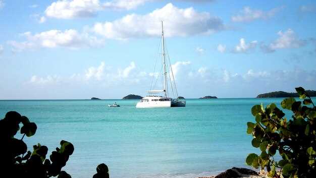
Rezervă un charter pe un yacht în Bahamas Abacos anul acesta pentru a te bucura de un caribbean experiență de navigație cu familia sau prietenii. Un itinerar de 7-10 zile funcționează cel mai bine, cu Iahturi cu 3-4 cabine care oferă tuturor intimitate și confort. Începeți în Marsh Harbour, ceea ce simplifică legăturile aeriene, apoi explorați Hope Town și Treasure Cay; traseul folosește ape calme, plaje aurii și beautiful un peisaj care menține marinarii energizați. Un plan bine pus la punct umple zilele cu snorkeling, vizite pe insule și seri la bordul unei ambarcațiuni înrădăcinate în moștenirea bahamiană.
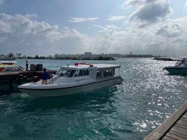
Aranjați sosirile prin Marsh Harbour airport sau Treasure Cay airport, apoi conduceți pe drumul scurt de la plymouth la baza ta și urcă-te la bordul iahtului tău. Caută bărci cu 3-4 cabine, un salon spațios și o punte de plajă; o bucătărie bine echipată ușurează aprovizionarea. Mai jos la suprafață, vei găsi apă limpede ideală pentru snorkeling, iar echipajul tău poate aranja vizite la situri istorice care fac ecou moștenirii arhipelagului.
Tarifele de charter în Abacos variază de la aproximativ 2,500 dolar pe zi pentru o barcă mică, cu 2-3 cabine, pentru a 6,000 dolari pe zi pentru un catamaran premium cu 4 cabine. Pentru o navă confortabilă cu 3 sau 4 cabine, așteptați-vă la aproximativ 3.500–4.500 dolari pe zi în sezonul de vârf, ceea ce se traduce aproximativ prin 24.500–31.500 un dolar pe săptămână. Chiar și cu un buget mai restrâns, maximizezi valoarea per dolar printr-o aprovizionare atentă și un skipper inteligent.
What de împachetat include haine ușoare, protecție solară sigură pentru recife, o pălărie cu boruri largi și un waterproof geantă pentru excursii pe litoral. Adaugă un cameră compactă for golden shot-uri la oră și câțiva bănuți bahamieni pentru bacșiș.
Lasă-ți echipajul să te ghideze spre golfuri adăpostite, faruri și restaurante de pe malul mării, ca serile să fie pline de muzică ușoară și arome bahamane. Coasta Abacos oferă beautiful priveliști, un patrimoniu bogat și un sentiment de libertate care rezonează cu marinarii ce prețuiesc un ritm relaxat. Dacă planificați o ședere mai lungă, luați în considerare legăturile rutiere dintre Great Abaco și insulele din jur, pentru a vă prelungi timpul și a vă bucura de și mai multă lumină aurie peste apa turcoaz.
Condiții practice de navigație și vremea în Bahamas
Planifică-ți vizita în sezonul uscat, din noiembrie până în aprilie, pentru vânturi constante și dimineți liniștite care îți permit să te bucuri de timpul petrecut pe punte și la țărm.
Vânturile bat din est sau nord-est, de obicei cu 12–20 de noduri, cu rafale ocazionale de până la 25 de noduri. Un front rece care trece poate aduce o schimbare scurtă spre nord sau vest și rafale mai puternice, așa că trebuie să fii atent la prognoză și să fii pregătit să micșorezi velele. Când vântul este constant, menținerea unui curs între nisip și recife se simte predictibil și poți călători între dane cu încredere.
Marea rămâne liniștită în interiorul lanțului Abacos. Așteptați-vă la valuri de 0,3-1 m în zonele protejate și de 0,6-1,8 m în larg, când alizeele bat mai puternic. Astfel de condiții fac ca folosirea unui plan de navigație ușor spre mediu să fie sigură și veți părea încrezător în timp ce alternați perioadele de calm cu o dâră scurtă și curată în urma iahturilor dumneavoastră.
Temperatura și vizibilitatea sunt favorabile pentru majoritatea activităților. Temperatura aerului variază de la mijlocul anilor '70 până la începutul anilor '90 Fahrenheit (24-34°C), iar apa are o temperatură cuprinsă între mijlocul și sfârșitul anilor '70 (26-29°C). Apusurile limpezi, în dungi, peste apa verde creează un fundal memorabil pentru priveghiul de seară, și vei descoperi că plajele rămân primitoare după o zi lungă de navigație sau scufundări.
Modele sezoniere și sfaturi de planificare:
- Sezonul uscat (Nov–Apr): vânturi comerciale constante, dimineți mai calme și condiții excelente pentru croaziere de o zi între Marsh Harbour, Elbow Cay și opririle ulterioare. Acesta este un moment bun pentru a vizita cu copii sau clienți care caută croaziere relaxante și timp de calitate cu familia.
- Sezonul ploios (mai–octombrie): umiditate mai ridicată și ploi zilnice. Aversele puternice de după-amiază sunt frecvente, iar sezonul uraganelor se desfășoară din iunie până în noiembrie, așadar monitorizați atent presa și prognozele și aveți un plan de rezervă pentru schimbări rapide.
- Fronturi și schimbări de vânt: fronturile reci dinspre nord pot sosi cu vânturi puternice, de scurtă durată; tratează-le ca pe un semn să ajustezi planurile de navigație și să ancorezi într-un loc adăpostit înainte de apus.
Navigație practică și confort la bord:
- Ancoraje și rute: căutați golfulețe protejate de-a lungul coastei de sud a insulei Great Abaco și în jurul Man-O-War și Guana pentru a reduce expunerea în perioadele instabile.
- Configurare la bord: cabinele rămân confortabile cu o ventilație bună; un grătar pe punte ajută la menținerea flexibilității meselor în timpul deplasărilor variabile între opriri.
- Plaje și scufundări: Abacos oferă apă verde și limpede, precum și locuri superbe pentru scufundări; planificați o zi de scufundări sau snorkeling atunci când fereastra meteo rămâne deschisă și marea este suficient de calmă pentru o intrare relaxată.
- Comunicații: aveți la bord un VHF fiabil și o opțiune de satelit pentru actualizări; folosiți prognoza meteo și simulările modelelor numerice pentru a stabili orele de plecare și sosire, mai ales când aveți oaspeți la bord care se așteaptă la o zi relaxantă.
- Cunoștințe locale: localnicii și dogarii de-a lungul docurilor vă pot oferi informații despre condițiile actuale, sfaturi de pescuit și locuri sigure de acostare, potrivite planului dvs. și denumirii următoarei opriri.
Sfaturi pentru o vacanță fără griji:
- Ia cu tine o jachetă subțire pentru diminețile devreme și serile târzii; aerul poate fi mai rece lângă apa deschisă, chiar și când soarele e sus pe cer.
- Pregătește mese flexibile și un plan solid pentru grătar; vei aprecia opțiunea de a găti la bord într-o după-amiază liniștită, când călătoriile pe uscat sunt limitate.
- Păstrează o rutină simplă, repetabilă: verificări ale sistemului înainte de zori, verificări ale recifului la mijlocul dimineții și o vizită pe țărm la apus pentru a profita la maximum de timp și de ferestrele meteo.
- Cunoaște-ți limitele și limitele echipajului tău; dacă vremea pare incertă, adaptează-te la un plan conservator și bucură-te de un loc confortabil de ancorare sau de un port protejat.
Fie că ești un călător aflat la prima experiență sau un căpitan experimentat, aceste condiții te ajută să găsești ritmul potrivit pentru o vacanță în Bahamas Abacos, cu mări limpezi, ceruri în dungi ca bomboanele și plaje memorabile. Caută un echilibru între aventurile subacvatice, croazierele liniștite și timpul petrecut cu localnicii care te pot îndruma spre cele mai bune locuri de vizitat, zi după zi.
Sezoanele optime pentru chartere în Abacos și modul în care alizeele influențează itinerariile
Cea mai bună perioadă pentru a închiria în Abacos este din noiembrie până în aprilie, când alizeele de nord-est rămân constante la 15-20 de noduri și predomină zilele senine. Această fereastră menține confortul pasagerilor ridicat, minimizează întârzierile de călătorie și oferă zile mai calde cu nopți mai răcoroase de care călătorii se bucură. Marinarii de la cluburile locale sfătuiesc că rezervarea timpurie asigură cele mai bune prețuri și asigură o experiență mai lină în jurul orașului Plymouth. Sfatul marinarilor experimentați te ajută să te adaptezi la vânturi, curenți și opțiuni de ancorare. Călătorii vor găsi arhipelagul Abacos plin de satisfacții.
Din mai până în octombrie, aerul mai cald și vânturile schimbătoare aduc mai multă variabilitate. Planifică salturi mai mici între Marsh Harbour, Hope Town, Green Turtle Cay și Man-O-War Cay, cu ancoraje în canale protejate. Așteaptă-te la blocaje meteo și averse și folosește actualizările clubului sau ale presei pentru a-ți rafina planul. Iarna, s-ar putea să apară balene pe canalele exterioare, adăugând o notă specială călătoriei.
Vânturile alizee din NE îți ghidează cursul; trasează o rută cu puncte de referință între Marsh Harbour, Elbow Cay și Green Turtle Cay, apoi virează spre sud de-a lungul canalelor către Guana Cay și Cherokee Sound. Pentru echipaje mai mici cu barca fără echipaj, menține distanțele sub 20-30 de mile și preferă plajele cu nisip și golfurile adăpostite pentru opriri peste noapte. Dacă condițiile s-ar schimba, poți ajusta la un curs mai scurt și poți rămâne într-un port liniștit; recomandat Pentru călătorii mai lungi, abordarea este alternarea etapelor mai lungi cu ancoraje scurte. Această planificare pragmatică este comună printre navigatorii care sunt precauți în privința acurateței prognozelor.
Verificările asigurărilor și ale echipamentelor reprezintă osatura practică a unei călătorii fără probleme. Majoritatea charterelor includ echipament de siguranță, hărți și un ghid de navigație, oferind o ambarcațiune pregătită pentru pasageri, potrivită pentru călătorii între orașele locale și centrele de transport. Plymouth este o oprire convenabilă pentru vizite pe țărm și realimentare; planificați 4-7 zile într-un itinerar tipic cu 2-3 ancorări per etapă pentru a maximiza confortul și a beneficia de cele mai bune vânturi, lăsând totodată loc pentru flexibilitate.
Viteze medii ale vântului, înălțimi ale valurilor și starea mării, pe luni
Planifică chartere în februarie pentru tranzacții mai stabile și mări mai calme, ideale pentru oaspeții care doresc să navigheze între golfuri cristaline și puncte nisipoase de-a lungul rutelor insulei.
| Month | Vânt mediu (noduri) | Înălțimea valurilor (ft) | Sea state |
|---|---|---|---|
| January | 15–20 | 2–4 | 3–4 |
| february | 16–21 | 2–4 | 3–4 |
| March | 14–18 | 2–3 | 3 |
| April | 12–16 | 2–3 | 2–3 |
| May | 10–14 | 2–3 | 2–3 |
| June | 8–12 | 1–2 | 2 |
| July | 7–11 | 1–2 | 2 |
| August | 7–10 | 1–2 | 2 |
| September | 6–9 | 1–2 | 2 |
| October | 9–13 | 1.5–2.5 | 2–3 |
| November | 10–14 | 2–3 | 2–3 |
| December | 12–16 | 2–3 | 2–3 |
Acest model susține o vacanță echilibrată, majoritatea itinerariilor fiind construite în jurul destinațiilor apropiate și a locurilor emblematice. Când navigați, luați în considerare o oprire la golfulețe cristaline și țărmuri stâncoase, cu o escală aeroportuară către următoarea destinație, dacă este necesar. Iahturile navigate de oaspeți vor beneficia de vânturi previzibile, în timp ce zile suplimentare pot fi adăugate pentru a explora plaje cu nisip sau pasaje de recif. Costul în dolari rămâne stabil pentru săptămâni bine planificate, iar o călătorie de 7-9 zile oferă un circuit complet al insulei și al locurilor sale, cu un preț clar pentru echipament și echipaj.
Curenți, maree și sfaturi de navigație în jurul lanțului Abaco
Planifică fiecare etapă în jurul ferestrelor de acalmie și verifică tabelele de maree cu căpitanul înainte de plecare. Începe dimineața, când alizeele ușoare stabilesc schimbări previzibile și țintește sosiri pe lumină la destinațiile sau docurile preferate de pe coastă. De-a lungul lanțului Abaco, balizele de zi în dungi și canalele scobite în stâncă ghidează rutele; bazează-te pe ele pentru a-ți alinia apropierea și a confirma că rămâi în ape sigure în jurul trecătorilor și ancorajelor cheie.
Așteptați-vă ca curenții de suprafață să atingă 1–3 noduri în pasajele principale, cu rafale mai puternice de până la 4–5 noduri când vânturile de nord-est bat prin spațiile deschise. Între insule și de-a lungul coastei, curenții se îmbină cu fluxul și refluxul, creând zone de curgere mai rapidă lângă canale precum Whale Cay și în jurul golfurilor mari. Odată cu vânturile de iarnă, păstrați o marjă pentru rafalele bruște și ajustați viteza din timp pentru a preveni ridicarea pupa-trimului lângă recifele puțin adânci.
În zona Abaco, mareele prezintă o amplitudine modestă, de obicei între 0,3–0,9 metri (1–3 picioare), cu maree de sizigii care ating scurt valori mai mari și maree cuadratice mai mici. Planificați traversările astfel încât să coincide cu amplitudinea mareelor mai mari atunci când traversați canale înguste; coborârea pupii suficient pentru a expune un banc de nisip sau o stâncă superficială poate economisi timp, dar necesită un control precis al cârmei și o mână sigură la volan.
Folosiți canalele marcate și mențineți-vă pe partea sigură a recifelor, în special în jurul aflorimentelor stâncoase din apropierea coastei și lângă pasajele dintre insule. Dacă ancorați lângă Marsh Harbour, Hope Town sau Man-O-War Cay, fiți atenți la marcajele mai mici, cu dungi de bomboane, care indică zonele puțin adânci și benzile de circulație spre exterior. Mențineți o viteză constantă, evitați să treceți repede prin pasaje strâmte și verificați adâncimea de două ori înainte de a vira brusc într-un golf aglomerat sau lângă un zid al portului.
Pentru călătorii americani cu chartere tip cabină și echipaje familiale, condițiile de iarnă aduc un aer mai răcoros și dimineți mai calme, dar marea se poate înăspri după un front. Includeți răbdare în program și alegeți distanțe mai scurte între destinații familiare; climatul permite zile confortabile de navigație, inclusiv sejururi lungi în porturi primitoare unde vă puteți odihni într-o briză ușoară și vă puteți bucura de ospitalitatea locală și de casele de pe coastă. Construiți-vă cunoștințele teoretice din experiențe reale și păstrați un plan flexibil care se adaptează la schimbările de vânt, claritatea apei și confortul fiecărui pasager de la bord.
Instrumente de prognoză meteo și surse de date fiabile pentru planificare
Flux de lucru recomandat: verificați prognoza marină a Serviciului Meteorologic din Bahamas și prognoza tropicală NWS/NHC cu cel puțin 48 de ore înainte de plecare. Albert, un căpitan din Marsh Harbour, verifică mai întâi prognozele oficiale și apoi compară datele modelului pentru următoarele 3-5 zile. Dacă doriți o planificare sigură, blocați o fereastră de 3 zile pentru etapele mai lungi și setați verificări de 24 de ore pentru modificările din ziua respectivă, acoperind charterele de iarnă și pe tot parcursul anului.
Surse și instrumente de bază includ prognoze oficiale, imagini din satelit și observații de la balize. Folosiți produsele Bahamas Met Office pentru prognozele costiere și insulare și NHC pentru activitatea tropicală. Pentru datele modelului, trageți execuțiile ECMWF și GFS (și UKMET dacă este disponibil) și vizualizați-le în Windy, Meteoblue sau instrumente vizuale similare. Dacă doriți o bază rapidă, aceste straturi oferă vânt, înălțimea valurilor și presiunea, și le puteți susține cu observații de la terenurile și balizele din apropiere.
Pericole cheie de urmărit: intensificarea vântului, rafale în apropierea recifelor, mare agitată și schimbări bruște când trec fronturile. Stabiliți praguri conservative pentru traversările de zi: 15-20 de noduri tipic, 20-28 de noduri pentru deplasări scurte de-a lungul coastei iarna, și fiți pregătiți să schimbați ruta dacă rafalele cresc brusc. Nu ratați o actualizare de 12 ore; ajustați-vă planurile, sunați echipajul și mențineți marje de siguranță între etapele în larg și locurile de ancorare protejate.
Fiabilitatea și sincronizarea datelor: bazați-vă pe observațiile insulelor, zonele maritime, datele satelitare și măsurătorile de la balize. Prognozele se actualizează la fiecare 6-12 ore; verificați comparativ ultimele perspective de 72 de ore cu rularea curentă de 24 de ore. Dacă aveți probleme cu o sursă, asigurați-o cu un al doilea sistem și mențineți-vă itinerariul flexibil.
Itinerare și aprovizionare: stabiliți itinerare cu marje, alocând timp pentru verificarea vremii. Pentru confortul și siguranța pasagerilor, planificați etape mai scurte în perioadele instabile și ancorați când se apropie fronturi. Când planificați cumpărăturile, estimați cu aproximativ un dolar mai mult pentru întârzieri și păstrați o aprovizionare cu produse care se pot depozita la temperatura camerei; pentru cei care doresc să își facă provizii cu băuturi alcoolice, coordonați livrările la primul port de escală. Sunați din timp la marine pentru a confirma acostarea și serviciile, având o rută de rezervă în cazul în care se iscă furtuni.
Abilități și cursuri: îmbunătățiți interpretarea vremii cu cursuri scurte oferite de cluburile de navigație sau operatorii charter; concentrați-vă pe citirea vânturilor, a fronturilor și a rezultatelor modelului. Doriți să vă îmbunătățiți abilitățile? Aceste cursuri vă ajută să planificați cu mai multă încredere în diferite perioade ale anului. Albert beneficiază de practică cu diferite ansambluri de prognoză și de învățarea evaluării riscurilor în raport cu acostările și confortul pasagerilor, în timp ce tu trasezi itinerarii potrivite climatului local și creșterii nivelului mării.
Echipament, siguranță și împachetare adaptate condițiilor de navigație din Bahamas
Împachetează un kit de siguranță compact, impermeabil și un radio VHF marin cu baterii de rezervă pentru fiecare călătorie, plus verifică acoperirea asigurării pentru o închiriere fără echipaj și opțiunile de evacuare medicală pentru oaspeți. Ai la îndemână o baliză de rezervă, rachete de semnalizare și un fluier, și depozitează-le într-o geantă uscată lângă gura de vizitare, astfel încât oaspeții să le poată lua rapid dacă vremea se schimbă de-a lungul coastei.
Poartă straturi cu uscare rapidă în nuanțe de verde și pastel; acestea rămân vizibile pe punțile albe și recifele de corali. Pune în bagaj tricouri cu protecție UV, o jachetă de ploaie ușoară și pantofi de apă pentru țărmurile stâncoase. Folosește saci impermeabili în verde sau pastel pentru a separa hainele curate de echipamentul îmbibat de soare. Păstrează toate echipamentele de navigație ferite de stropi într-un sac impermeabil de 10 litri sau într-o husă rezistentă la apă. Ia cu tine o ancoră robustă cu o lungime de 1:7 pe mare moderată, plus o geamandură de ancorare compactă, ajustabilă și o lumină de ancoră adecvată pentru coastă, pentru nopțile la ancoră în apropierea insulelor din zonă.
Pentru navigație, bazează-te pe un plotter cartografic dedicat și pe hărți nautice tipărite ale insulelor Abaco. Păstrează o listă tipărită cu puncte de trecere și locuri sigure de ancorare, marcate cu culorile geamandurilor, și verifică adâncimile înainte de a te apropia de zonele puțin adânci. Poartă o busolă de rezervă și o baterie GPS de rezervă. În caz de vijelie, ai la îndemână o stație VHF portabilă ca rezervă și urmează sunetul traficului din apropiere și semnalele balizelor pentru a evita bancurile de nisip. Caută semnele de apă cristalină ale recifilor și planifică rute pentru escale ușoare și directe între insule, cu porturi de agrement și restaurante în apropiere, pentru ca oaspeții să găsească o masă grozavă după apusul soarelui.
Nopțile din decembrie pot aduce aer mai rece și vânturi ușoare. Puneți în bagaj un polar, pantaloni lungi și un sac de dormit compact pentru nopțile în cockpit. Crema de protecție solară rămâne necesară, iar ochelarii de soare cu curele de fixare plus o pălărie cu boruri reduc strălucirea pe apa cristalină. Păstrați o lanternă frontală compactă pentru verificările punții și o cabină bine ventilată pentru a preveni mucegaiul după ploaie. Aveți o vestă de salvare bine fixată pentru fiecare oaspete, inclusiv o opțiune gonflabilă ușoară pentru utilizare facilă pe punte.
Pentru pescuit și viața sălbatică, luați cu voi un kit simplu: o lansetă de 1,8-2,4 metri, fir de 4,5-9 kg, o mică selecție de momeli și un minciog. Respectați regulile și limitele locale; bancurile de pești-os se întind de-a lungul coastei și canalelor din apropiere. Observarea balenelor are loc în larg pe anumite rute, așa că păstrați o distanță respectuoasă și folosiți recuperări lente și constante. În orașele din apropiere puteți găsi frânghie de rezervă, cleme și accesorii de la dogari și brutari pentru reparații rapide. Unii operatori britanici preferă echipamente compacte și durabile. Asigurați-vă că echipamentul este clătit după stropirea cu sare când vă întoarceți la barcă și informați oaspeții cu privire la practicile sigure de prinde-și-eliberează.
Verificare înainte de plecare: asigură-te că vestele de salvare se potrivesc tuturor oaspeților, testează luminile stroboscopice și claxonul, verifică dacă GPS-ul și VHF-ul au baterii noi și confirmă termenii asigurării pentru charter. Alcătuiți un plan simplu de urgență și împărtășiți-l cu toată lumea. Înregistrează porturile de agrement, danele de alimentare și actualizările meteo din apropiere pentru câteva zile de navigație; reține că fronturile din decembrie se pot schimba rapid, așa că fii cu ochii pe cer și pe apă pentru schimbări de culoare care semnalează adâncime sau expunerea recifului. Cu această pregătire, te poți deplasa lin între insule și te poți bucura cu încredere de apa cristalină și de nopțile răcoroase.