

 Marine Weather Patterns and Forecasting – A Deeper Dive for Sailors">

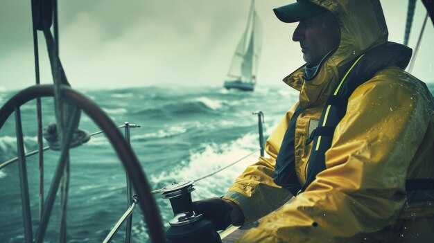
Always review the morning forecasts for your route and adjust your sail plan accordingly. This quick check helps you know when calms may linger and when brisk winds will build speeds along the course, guiding your navigation decisions and the vessel’s readiness.
Weather moves in formations shaped by pressure systems and thermal contrast; example, a passing trough can sharpen winds from the shore and alter seas. These cues often require you to time sail changes, adjust heading, and keep the vessel on track while you watch the seas for any sudden shifts, guided by nature’s signals and the sailors’ experience.
To forecast with confidence, use a small, repeatable process: check two reliable models, compare surface observations, and know your vessel’s performance. Specifically track wind shifts, gusts, and sea turning, then adjust sails and speeds to suit cruising legs. Record how these changes affect the vessel’s trim and comfort.
During early morning windows, keep an eye on gust fronts approaching from the land, and watch for calms that can reduce boat speeds. Create a simple plan for the next two legs, mapping departure times, tacks, and sail adjustments so the crew stays coordinated.
Keep data current and share key updates with the crew; forecasts become practical when you translate them into concrete actions for every leg, from harbor to open sea. This approach supports calmer handling, safer navigation, and a smoother cruising experience.
Reading Zone Marine Forecasts: Wind, Gusts, and Speed Thresholds
Read the zone forecast and set your sail plan from the numbers: sustained wind, gusts, and their changing trend. For offshore passages on these voyages, reef early and keep a safety margin when gusts approach 30 knots. Use predictwind data and satellite updates to verify the forecast and shorten response time.
These forecasts provide direction, wind speeds, gusts, and water heights. Pressure trends and changing heights signal potential storms; a rapid drop in pressure with a shifting wind pattern often precedes gusty periods. In such windows, shorter legs, smaller sails, and a cautious course keep the crew safe and the boat balanced.
Interpreting wind speeds, gusts, and thresholds
- Sustained wind versus gusts: gusts typically add 20-40% to the sustained value; plan for gusts to reach the upper threshold.
- Gust thresholds: watch for gusts above 25 knots in light to moderate conditions; reef or adjust sails when gusts approach 30 knots offshore.
- Wave heights: 15–20 knots often produce 1–2 m waves; 25–30 knots can push 3–4 m, with larger sets during squalls.
- Symbols on the forecast: larger or bolder symbols indicate higher winds; these symbols mean less guesswork and quicker decisions.
- Direction: a steady wind path confirms risk of a front; a sudden shift in direction often precedes gusty bursts.
- Pressure trend: falling pressure is a warning sign for increasing winds and rougher water; rising pressure suggests improving conditions.
- Associated activity: combine wind, gusts, and wave height to judge boat handling needs and crew workload.
- robert’s tip: keep a simple log of wind shifts and sail trim to refine readings for these zones and future passages.
- Fish and wildlife: wind shifts and water roughness influence fishing spots and shore activity; plan lookouts accordingly.
- deer: coastal sightings remind you to remain vigilant near estuary approaches and crowded ramps during transitions between zones.
Practical steps for these voyages
- Before departure, set thresholds for each leg: reef when gusts exceed 28–30 knots, and choose smaller sails or revised course for offshore legs.
- During the leg, reef promptly if gusts break the set threshold; adjust heading to keep the breeze from the beam when possible to reduce heel and load.
- Use satellite data alongside the provided zone forecast to confirm stability; cross-check with predictwind for near-real-time updates.
- Monitor pressure trends: a 6–8 hPa drop in 6 hours usually signals a strengthening wind window; plan reefing steps in advance.
- Watch wave heights relative to wind: if water shows faster build toward 3–4 m, shorten the leg or seek sheltered water to reset the plan.
- Keep a simple log of wind direction changes and sail responses; robert’s approach helps you build a faster reaction routine for these voyages.
- In coastal zones, factor wildlife and shore activity into your lookout routine; use forecast signals to time transitions when the shoreline activity is calmer.
Interpreting Sea State: Waves, Swell, and Periods for Planning
Check the swell period and height now to set a safety-first cruising plan, then review pressure trends, storm systems, and the tide for your route.
Reading the Numbers: Waves, Swell, and Periods
Waves are generated locally by winds; swells originate from distant storm systems and can arrive beyond the immediate fetch, delivering a smoother roll. The period, in seconds, shows how quickly crests pass a fixed point and helps you estimate peak forces on the hull and rig. Generally, short periods (under 8 seconds) signal wind waves near shore, while longer periods (over 12 seconds) indicate long-period swells that persist beyond coastal shelves. Early forecast data from operators provide a range; then you compare this with sea-surface temperatures and wind direction to judge risk. robert, a seasoned cruiser, notes that reading the period helps you plan safe transit near river mouths and the shore. Provided you see sudden shifts in pressure or wind, expect sudden changes in wave height and plan safety margins. For coastal regions, animal behavior such as seabird patterns can hint at shifting conditions. Near the shore, lower water and tide can amplify energy. Always cross-check several sources and include a contingency plan for possible changes.
Planning in Practice for Sailors
To translate numbers into actions: identify the swell direction relative to your course, choose routes that keep the helm in manageable trim, and avoid attempting heavy maneuvers in shallow water near the shore or in tide-dominated channels. Always have a safety margin and a contingency plan, especially for cruising with multiple crew. Several options exist: delay departure for an early lull, reroute offshore, or seek sheltered harbors provided weather allows. In practice, rely on multiple forecast sources, compare models, and factor in temperatures and river outflows that modify wave energy. If the data comes from buoys and satellites, use it to guide decisions; didnt rely on a single source. This approach keeps sailors safe and helps you maintain course efficiency and safety.
Currents, Tides, and Coastal Impacts in Zone Forecasts
Plan passages to ride slack water windows; check the zone forecast for currents, tides, and coastal impacts at least 6 hours ahead to decide safe routes for inlets and shoals and avoid strong flows in short legs.
Current origins lie in tides, wind-driven flow, and offshore pressure systems. Inlets and coastlines create strong shear, and a front moving alongside the coast can cause rapid shifts in speed and direction within hours. Keep charts handy and compare with buoy data to confirm the forecasted trend.
Since the forecast depends on tide phase, fronts, and storm activity, the exact current speed varies; this matter informs navigation and helps you decide when to sail and how to adjust course. This is a critical input for risk assessment; an aspect of forecast use is recognizing how tides and fronts interact to raise or lower current strength and wave energy, yielding higher risk near headlands.
Precautions include timing passages for slack water, maintaining a wide margin from shoals, and having a contingency plan for gear damage or prop strikes. In narrow channels, do not push above 3–4 knots when a strong ebb is forecast; if showers and clouds approach, delay the move or seek shelter until winds ease.
Satellite data, radar, and surface observations provide information that helps you learn the timing of shifts and assess potential storm impacts. When a storm approaches, expect higher seas and more dynamic currents; use this to decide whether to sail now or hold until winds ease and the water stabilizes, sailing safely. Clouds, showers, and satellite cues together sharpen your navigation decisions and help protect gear from damage.
Weather Transitions: Fronts, Squalls, and Thunderstorm Risks
Identify the front ahead and set a plan now: note distance to the leading edge and track its progression across miles and routes. This knowledge gives mariners a clear basis for decisions and keeps you ready during the passage of a front. They play a key role in how you space the boat and coordinate with the crew; consider getting observations from more than one source to improve accuracy.
When a front crosses, expect wind shifts and rising seas: speeds change from 12-18 knots to 25-40 knots within 30-60 minutes, and wave heights can rise from 1.5-3 meters to 3-5 meters depending on fetch. Heavily loaded vessels should adjust sails そして reduce speed early. Track the front using cross-referencing radar, barometer, and satellite data to confirm its passage and timing, and use distance cues like cloud trends to maintain accuracy where possible.
Squalls can accompany the front or ride along its passage, delivering sudden gusts and brief downpours that reduce visibility to under 2 miles. Gusts commonly reach 25-50 knots for 5- to 15-minute bursts; seas respond quickly and wind swings can approach 20-40 degrees. If youre navigating, precautions リーフィングセール、機器の確保、安全なタックやエンジン速度に変更できるルートの準備を含みます。スクォールセルが航路を横切る可能性のあるラインの隙間を監視し、乗組員を注意させ続けてください。.
Thunderstorms introduce additional risks: lightning, downdrafts, and microbursts. Stay clear of the heaviest core by a buffer of 10-20 miles, and avoid being aligned with the storm where winds can surge. Cells can produce sustained winds 40-60 knots and gusts higher; track the storm using radar and cross-referencing data to maintain accuracy and choose a safer passage to the side or behind the line. The body of convective weather is dynamic, so you should expect rapid changes and keep the entire team informed. に移動し、安全な経路を選択するか、線の横または背後に避難してください。対流性の天候は動的であるため、急速な変化が予想され、チーム全体に情報を共有する必要があります。.
これらの移行期を通して、乗組員と知識を共有し、結束を保ち、安全マージンを維持してください。このアプローチは、航路やタイムゾーンを超えた実践的な洞察を海事に与えます。十分に練習された計画があれば、最も活動の活発なセルとの距離を保ち、その通過を追跡し、それに応じて航路を調整する準備がより整います。覚えておいてください。風の評価、セルまでの距離、そして対流の確率の精度は、安全を向上させ、自信を持って次の途中山標に向かって進むことができます。.
予報から航海へ:実践的な航路計画とリスクチェック
航路の最新の気圧変化傾向と風速予測を確認し、その後、サンゴ礁の危険地帯を避け、海岸から離れた安全な航路を作成してください。.
この計画では、モデルを比較し、風と海を駆動するシステム、風の起源を含む検討を行う必要があります。複数の予報を使用し、信頼できる地元の情報源で確認してください。.
安全な避難港または海岸への侵入を正確に定義し、タックおよび旋回の秒単位の余裕を記録し、出発前に海図上で旋回点をマークしてください。.
危険を予測する:熱帯性の急雨、荒れた波、礁、および海岸付近の動物の動き。状況が悪化した場合の潜在的な脱出経路を特定する。.
変更のトリガーを設定する際には、推測はいけません。風向、風速、海象、および分単位の気圧変化の詳細を確認してください。.
潮汐と潮流のデータにアクセスし、夜明けや夜の潮汐のタイミングを確認し、海岸付近で潮流が止んだ後に出発して操縦性と安全性を最大限に高める計画を立ててください。.
提供された安全マージン:サンゴ礁の縁から少なくとも2海里、浅瀬から1.5海里を保ち、他船の航行を避け、海岸やデッキの安全まで十分な余裕を持っておく。.
並行計画を立てる:予報された状況が悪化した場合、次の保護された海岸線または避難場所に向かって別のルートに切り替え、代替経路を航海日誌に記録してください。.
アプローチの知識と、実践的な天気予報リテラシーの組み合わせが、自信を育みます。気圧の変化、熱帯の警告、風向のアップデートを監視して、必要に応じて即座に調整できるようにしましょう。.
夜間航行では、規律正しい見張りが求められます。速度低下、方位照合、グレアへの備え、適切な灯火の使用、わさびや潮流への警戒を怠らないでください。.