

 Top 10 Most Popular South Carolina Cities for Boating | Best Boating Spots in SC">

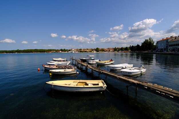
Base your SC boating plan in Charleston today: rent pontoons for a half-day, check tide windows, and head out to nearby creeks for a relaxed cruising style. A required safety briefing and life jackets keep everyone secure before you leave the marina, then follow a simple route that avoids crowded channels.
Data from SC tourism shows Charleston, Georgetown, and Hilton Head lead registrations and boater traffic, with boaters often planning weekend trips that combine saltwater cruising with family time to gain a richer experience. Expect 2-4 hours on a harbor loop, then spend time in nearby creeks and marshes to snap picturesque views from the deck.
In salem you find calmer inland boating with easy access to lakes where pontoons glide at 3-6 piedi depths. The wando area offers tidal inlets perfect for cruising with a light craft. trout fishing can accompany your trip on calm mornings near Georgetown and other estuaries.
Choose a boat style that fits your plan: pontoons shine for family days, deck boats handle closer shorelines, and small bass boats suit inland lakes. For best results, study tide and wind data before you head out, and keep a log of nearby hotspots to guide your next outing. If you crave a mix of land and sea, look for beaches with gentle surfing to pair a shoreline cruise with surfing sessions.
Il opportunities across Charleston, Georgetown, Myrtle Beach, Hilton Head, Beaufort, Mount Pleasant, Isle of Palms, salem, wando area, and surrounding lakes give boaters plenty of choices. Plan multiple trips to compare picturesque coastlines, salt marshes, and tidal creeks, and use data from your own experience to refine future spend and routing.
South Carolina Boating: Plan for Top Cities and Hilton Head Highlights
Base Hilton Head as your core for peaceful, unspoiled waterways and easy access to tidal creeks; plan short hops to Charleston and Georgetown to maximize time on the water.
SC’s coast features coastal citys including Charleston, Myrtle Beach, Georgetown, Beaufort, Hilton Head, and Kiawah Island, each offering a distinct boating rhythm. Charleston sits at the confluence of the Ashley and Cooper Rivers, delivering protected channels for powerboats and fishing charters, plus Fort Sumter views just off the harbor. Myrtle Beach delivers expansive salt flats and winding tidal creeks ideal for cruising and bar hopping. Georgetown anchors a calmer Winyah Bay scene with easy river access and offshore grounds for trout and redfish near the inlet. Beaufort pairs quiet creeks with moss-draped oaks, while Hilton Head blends Harbor Town views, Calibogue Sound, and Broad Creek for kayak sessions and shell-rich paddles. Kiawah adds barrier-island marshes and wide salt flats for shallow-water exploration.
Hilton Head highlights: Harbor Town marina welcomes powerboats and kayaks with clear dock access, and the Calibogue Sound corridor offers wind-protected routes for family outings. The Broad Creek area provides peaceful paddling through marsh grasses, where you may glimpse pelicans, herons, and prey-rich schools. limehouse eateries along the water offer a fresh bite after a day on the salt. Fort Sumter and nearby forts provide a quick historical view between tides. Spring and fall bring comfortable weather for longer days on the water, with summer days ideal for beach stops and sandbar hopping.
Practical plan by city: Start in Charleston for harbor cruising, then move north along the coast to Georgetown or Beaufort; a 2-3 hour powerboat hop between key spots fits most day trips. From Myrtle Beach, run salt-water creeks toward Garden City Inlet for trout and redfish, or explore the Inlet and its bars by kayak. In Hilton Head, stay at Harbor Town or Shelter Cove and explore Calibogue Sound and Broad Creek on a flexible schedule. In Kiawah, target marsh edges and tidal creeks for quiet paddling. Make the most of each stop by planning two to four hours on the water, ensure street access at launch sites near marinas, stay aware of weather, and recharge with a lunch on a sandbar or riverside park. Keep the docks accessible for a smooth next leg.
Top 10 Most Popular South Carolina Cities for Boating: Best Boating Spots in SC; 7 Hilton Head Island
Starting with Hilton Head Island makes the best first move for a balanced, long day on the water and a serene setting, with easy access to multiple watercraft rentals, charters, and clear routes through calm creeks.
- Charleston – Downtown Charleston anchors a dynamic boating scene with harbor cruises, Cooper River routes, and Morris Island views; charter fleets depart from several harbors, and kayaks slide through serene creeks around the salt marshes. There are multiple parks along the waterfront for a quick break, and you can cruise to Fort Sumter or linger in the harbor area to soak up the citys historic vibe.
- Myrtle Beach – A long, sandy coastline and the Intracoastal Waterway converge for day trips and sunset cruises; charters and watercraft rentals line the Boardwalk area, while nearby Murrells Inlet offers calmer paddling for kayaking enthusiasts. The head of the area provides easy access to park spaces and scenic marshes, perfect for enjoying a family-friendly boating afternoon.
- Columbia – Lake Murray sits just west of the city and spans tens of thousands of acres, delivering ample room for cruising boats, longer day trips, and jet-ski sessions; marinas provide vessel rentals and guided charters, while the Congaree River corridor offers downtown-facing views and riverfront parks for a quick break.
- Greenville – Within an easy drive to Lake Keowee and Lake Hartwell, Greenville offers nearby water access with multiple marinas and boat ramps; you can plan a longer paddle along the Reedy River or a morning cruise to surrounding coves, then head back to downtown for a stroll through the citys vibrant streets.
- Georgetown – Winyah Bay and the Sampit River anchor Georgetown’s boating scene, with serene tides and marsh creeks perfect for kayaking and small-boat cruising; local charters provide vessel options, and the historic waterfront park area gives a quick downtown escape after a day on the water.
- Beaufort – Port Royal Sound and nearby salt marshes create a classic Lowcountry cruising experience; downtown Beaufort offers a walkable waterfront, and nearby waterways are ideal for long afternoon sails or calm morning paddles in protected inlets.
- Hilton Head Island – The island headlines with a dense network of creeks, Calibogue Sound, and Broad Creek; charters and private guides offer vessel options for next-level exploration, while multiple parks and nature preserves provide serene viewpoints after a day on the water. Its head-start access makes it easy to plan a full day of cruising, kayaking, and sunset sails.
- Anderson – Located near Lake Hartwell (the hartwell region spans tens of thousands of acres), Anderson features public ramps, multiple marinas, and nearby watercraft rental options; expect solid options for day trips, longer cruises, and easy access to nearby towns for dining and scenic stops.
- Rock Hill – The Catawba River corridor and nearby Lake Wylie offer convenient day trips from Rock Hill, with parkland along the water and several boat ramps to keep trips flexible; you’ll find frequent chances to cruise through calm mornings and sunset cruises in a friendly, walkable downtown area.
- Spartanburg – While inland, Spartanburg serves as a gateway to several lakes such as Lake Blalock and other nearby reservoirs; multiple charters and local outfitters provide options for fishing and cruising, and easy access to parks keeps the trip balanced between water time and downtown dining.
источник: местные гиды по яхтингу и карты причалов; интерес к этим направлениям растет через годичные сезоны, когда семьи и энтузиасты ищут больше времени на воде и больше вариантов маршрутов.
Charleston Area: Marina access, ramps, and navigable depths
Use the Patriots Point ramp for fast offshore access and start your Charleston boating day with a relaxing ride.
Marina access around the peninsula is convenient: Shem Creek Marina provides public boat access with fuel, restrooms, and nearby ramps to slip into creeks for peaceful cruising.
Inshore, depths in the harbor approach typically range from 6–12 feet at mean low water, with main channels often 12–20 feet and offshore pockets exceeding 20 feet. Navigating these waters is straightforward when you stay on marked channels and check updated charts; plan your run for slack tide if you’re new to the area.
Along the lowcountry marshes, egrets and other wildlife populate the edges, making the Charleston area a peaceful backdrop for a relaxing day. Stop for a picnic in a sheltered cove, or anchor briefly to watch pelicans and fish schooling offshore.
Coloro che visitano oggi dovrebbero controllare le tabelle delle maree e gli avvisi della marina; inclusi i pontili di rifornimento, i bagni e gli orari di rampa nei porti turistici intorno a Patriots Point, Mount Pleasant e Shem Creek, per garantire una giornata senza intoppi con servizi di livello mondiale che gestiscono l'aumento del traffico del fine settimana.
Oggi l'area di Charleston offre una varietà di avventure ed esperienze per tutti, inclusa una facile accessibilità dalla rete di rampe e opzioni offshore che mettono in risalto il paesaggio del Lowcountry.
Myrtle Beach Corridor: punti di lancio, noleggio di imbarcazioni e itinerari per gite di un giorno
Partenza dal Boat Ramp del Parco Statale di Myrtle Beach, noleggia un kayak o una piccola imbarcazione e pianifica oggi tre percorsi compatti lungo le vie navigabili salmastre.
Launch points lungo il corridoio sono pratici e vicini: Myrtle Beach State Park Boat Ramp offre un facile accesso terrestre e parcheggio per l'attrezzatura; la rampa pubblica di Surfside Beach fornisce un collegamento rapido a zone pianeggianti poco profonde e canali più profondi; e il sito di lancio di Garden City Beach apre un po' più a sud per escursioni più lunghe. Ognuno ha mattine calme, un facile rientro e un accesso rapido ai corsi d'acqua marea, rendendo la transizione da terra ad acqua consapevole e fluida.
Noleggio barche provengono da attività locali che vendono kayak, tavole da paddleboard e piccole imbarcazioni a motore. Prenota in anticipo nei fine settimana, quindi scegli tra opzioni a ore o per l'intera giornata. I prezzi tipici variano da $25–$50 all'ora per kayak o paddleboard e da $120–$350 per imbarcazioni a motore, a seconda delle dimensioni e della durata. La maggior parte dei negozi fornisce giubbotti di salvataggio, sacche impermeabili e briefing sulla sicurezza di base, quindi puoi concentrarti sull'attività, non sui dettagli.
Percorso A (Loop di acqua salata, viste pittoresche): Parti dal MB State Park Ramp, pagaia lungo i margini delle zone umide salmastre e segui un canale poco profondo verso una confluenza dove due ruscelli si incontrano. Mantieni un ritmo attento, sbarca brevemente su una piccola isola per osservare gli uccelli marini e fai uno spuntino con un pasto al sacco prima di ritornare. Questo loop enfatizza la pagaiata in acque calme, la conservazione del bacino idrografico e la facile osservazione degli uccelli per principianti e navigatori esperti.
Percorso B (Canali navigabili e una sosta pranzo): Dirigiti verso sud in direzione di Garden City Beach, seguendo un canale più lungo che mantiene per lo più pendenze su acque calme. Fermati in un molo in stile limehouse o in un punto sulla riva per un pasto con insalata al lime e olive, quindi torna lungo le curve più tranquille. La confluenza dei corsi d'acqua qui crea uno scenario profumato di salsedine e l'opportunità di vedere banchi di muggini e aironi che guizzano sulla superficie.
Route C (Opzione di acque profonde e un rifugio): Per un'esperienza di pagaiata più intensa, immergiti nella zona MB, segui il canale principale fino a una vicina isola barriera e trascorri un breve rifugio su una pittoresca spiaggia sabbiosa. Porta con te acqua extra, crema solare e uno spuntino leggero; tieni d'occhio l'orizzonte per pellicani e delfini. Se raggiungi una piccola isola e desideri prolungare la giornata, puoi saltare tra piccole zone poco profonde e corsi d'acqua, mantenendo l'esperienza rilassata e piacevole per tutti i livelli di abilità.
Il piano di oggi dovrebbe mantenere un ritmo confortevole e bilanciato: trascorrerai del tempo in acqua salata e vie navigabili interne, troverai fascino in tranquille insenature e manterrai l'attività incentrata sull'osservazione, la sicurezza e i buoni passaggi da terra all'acqua. Se sei curioso di sapere quale isola incontrerai lungo il percorso B, probabilmente scoprirai un posto riparato e tranquillo ideale per un pranzo veloce o una pausa. Per un tocco locale, prova una breve sosta in un landing in stile limehouse lungo la confluenza prima di tornare alla rampa, quindi concludi con la visione del tramonto mentre la via navigabile brilla. Questo corridoio di Myrtle Beach offre opzioni accessibili, attrezzature affidabili e lo stile di navigazione che fa tornare i diportisti in questo bacino idrografico influenzato dal sale oggi.
Hilton Head Island: Sette posti da non perdere per gli amanti della nautica
Inizia con una crociera all'alba sul Calibogue Sound lungo l'Intracoastal Waterway, osservando la fauna selvatica e assaporando l'aria salmastra. Questa tranquilla zona offre viste sulla costa, uno splendido sfondo e un momento ideale per pianificare la giornata attraverso le acque interne che collegano le tue sette tappe.
| Spot | Access / Rampa | Highlights | Fauna & Stagione | Best Time | Tips |
|---|---|---|---|---|---|
| Calibogue Sound & Intracoastal Waterway | Harbour Town rampa pubblica; rampe Sea Pines nelle vicinanze | paesaggi costieri, saline, isole paludose, viste sull'acqua aperta | delfini, pellicani, uccelli acquatici; l'areale varia a seconda della stagione | alba fino al mattino; primavera-autunno spesso tranquillo | rimanere in canali più profondi, velocità moderata vicino agli scogli; lì lì prossima tratta dell'ICW |
| Skull Creek | Skull Creek Boat Ramp e i moli nelle vicinanze | tidal creeks, oyster beds, sheltered inlets, marina vibes | herons, egrette, occasionali delfini; attività annuale | early morning or late afternoon | controllare le barche basse e i letti di ostriche; sia il traffico di crociera che quello da pesca in quelle zone |
| Broad Creek | Rampa del Broad Creek Marina; breve tragitto da Shelter Cove | canali di retroguardia, erbe palustri, rive cespugliose | pelicani, falchi pescatori, avvistamenti di lamantini a volte | metà mattina a pomeriggio | naviga tra i rami e le zone poco profonde; c'è bellezza negli anfratti tranquilli |
| Port Royal Sound & Battery Creek | Port Royal rampe pubbliche; accesso a Battery Creek nelle vicinanze | comunità costiere storiche, crociera in acque aperte, corridoio ICW | tartarughe marine, aquile, uccelli costieri; picco nei mesi più caldi | tarda mattinata al pomeriggio | pianifica gambe lunghe tenendo conto delle correnti; non sfrecciare attraverso canali stretti |
| Jarvis Creek | Jarvis Creek Boat Ramp, area di Palmetto Bay | estuario protetto, mangrovie folte, insenature riparate | delfini, aironi, uccelli costieri | luce pomeridiana per i colori | le opzioni di ancoraggio sono abbondanti; fare attenzione ai rami vicino alle rive |
| Daufuskie Island Creek | Bloody Point Passage a Daufuskie; i percorsi dei traghetti a volte nelle vicinanze | vibrazioni dell'isola storica, coste non sviluppate, spiagge di conchiglie | vari birds, occasional dolphins; quiet seasonality | finestre stagionali; mattine più calme aiutano con il passaggio | pianificare una sosta a terra per la cena sull'isola; avere carburante e carte nautiche pronte |
| Beaufort River / Area batteria | ICW entrata a Battery Creek e Beaufort River ramps | città storiche lungo la costa salata, potenziale di crociera a lungo raggio | delfini, falchi pescatori, uccelli acquatici | estate in autunno | verificare le correnti prima di lasciare l'ICW; portare una linea extra e un sistema di ancoraggio adatto ai rami |
Each spot provides a different flavor of cruising, from protected backwaters to expansive saltwater passages. Have time to explore through the day, and next you’ll find how the range of scenery and wildlife keeps interest high. The islands’ historic keepsakes and bushy marshlands make it easy to connect with both nature and local culture, while a well-planned route lets you enjoy dinner ashore or aboard. Through careful planning, you’ll experience peaceful moments, speed when safe, and a day that fits years of boating memory.
Beaufort & Port Royal Waters: canali protetti e tranquille escursioni in canoa
Partenza da Port Royal Landing Marina nel centro di Beaufort e pagaia attraverso canali protetti che serpeggiano lungo Battery Creek e le paludi circostanti. Questo percorso ti tiene vicino a casa offrendo al contempo le più belle viste sull'acqua, e puoi consultare gli annunci di Boatsetter per scegliere un'imbarcazione che si adatti ai tuoi interessi, alla tua velocità e alla tua esperienza. Aspettati tratti di acqua piatta, coste incontaminate e abbondante fauna selvatica mentre ti muovi lungo le vie navigabili vicino a località vicine, rendendo questo un'esperienza di pagaiata piena di sentimento con opzioni per charter rilassati o un'uscita autoguidata.
- Port Royal Creek Loop – partire dalla marina, seguire i tranquilli corsi d'acqua attorno alle isole e ritornare tramite un canale parallelo e calmo. Questo percorso di 3–5 miglia (circa 5–8 chilometri) è ideale per principianti e famiglie, con acque calme e frequenti avvistamenti di fauna selvatica; rimanere vigili per i pescatori lungo le rive e le altre imbarcazioni sulle rotte principali.
- Beaufort River Marsh Edge – lancio dal centro e navigazione lungo i crepacci riparati dal vento lungo il bordo del fiume, passando attraverso zone umide intertidali e mangrovie. Aspettati un'escursione di circa 2–4 miglia con opportunità di vedere uccelli acquatici e pescatori; finirai vicino a un piccolo parco dove potrai sgranchirti le gambe e prendere uno spuntino in ristoranti nelle vicinanze.
Consigli pratici per massimizzare la tua esperienza: controlla le tabelle delle maree e le previsioni del vento prima di partire; l'alta marea offre spesso canali più profondi e passaggi più fluidi, mentre la bassa marea rivela zone sabbiose che vorrai evitare con un'imbarcazione più piccola. Porta con te acqua, crema solare, un cappello e una fotocamera compatta per catturare la fauna selvatica: i momenti più memorabili tendono a verificarsi lungo la prossima curva della via navigabile. Noleggia tramite Boatsetter per provare diverse imbarcazioni intorno al centro e a Port Royal; scegli un'imbarcazione che corrisponda alla tua velocità e al tuo comfort, quindi passa a un'altra se desideri un'esperienza variegata.
- Per un'esperienza più rilassata, mantieni basse le velocità nei corsi d'acqua vicino alla fauna selvatica e ai pescatori per ridurre al minimo le scie e proteggere le erbe palustri.
- Dopo la pagaia, controlla i ristoranti e i bar nelle vicinanze di Charleston lungo il lungomare per un pasto informale o un drink post-pagaia.
- Il parcheggio ad accesso pubblico è comodo a Port Royal Landing; se preferisci un ambiente urbano, il cuore del centro di Beaufort offre opzioni di parcheggio aggiuntive e una breve passeggiata per visitare le attrazioni.
- Le opzioni di Charter sono disponibili se desideri un percorso guidato che copra i segmenti più panoramici e punti caldi della fauna selvatica - questi servizi operano da Port Royal e aree del centro.
- La prossima volta, prova un ciclo più lungo che si curva attorno alle isole circostanti e attraversa nuove vie d'acqua per scoprire un mix ancora più ricco di fauna selvatica e panorami paludosi.