

 Sardegna Itinerario di Navigazione – Il Percorso Costiero Definitivo di 7 Giorni">

Start with a 7-day coastal loop that begins in Olbia and heads toward La Maddalena, delivering a first taste of Sardinia’s azure bays. Hire a capable boat for 2–4 guests, keep daily legs in the 20–35 nautical mile range, and you’ll enjoy a pearl-like mix of coves, charming town squares, and calm anchorages.
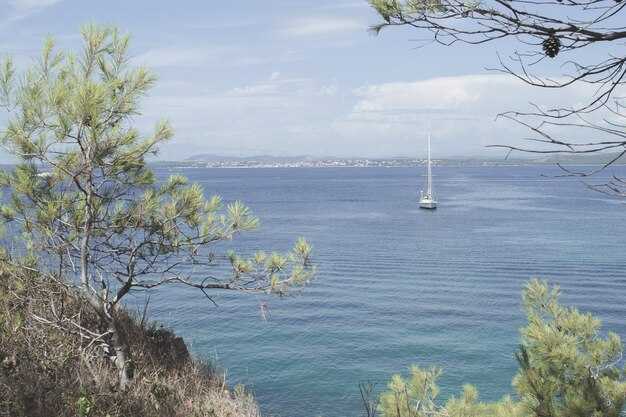
From Olbia, sail a sheltered leg to La Maddalena, where you can swim in turquoise water and explore the old town’s marina. In the afternoon, visit Caprera with its pine forests and quiet coves, or swing to Santa Teresa di Gallura to stroll the waterfront, pop into a portside bakery, and sample handmade gelato while chatting with locals visiting the harbor.
Continuing along the northern arc, anchor near Porto Cervo and Cala di Volpe, then ease toward the eastern Gulf of Orosei. A swim in azure coves, a stroll through a sunny town square, and snorkeling around shipwrecks tucked into sheltered reefs add intrigue to the day.
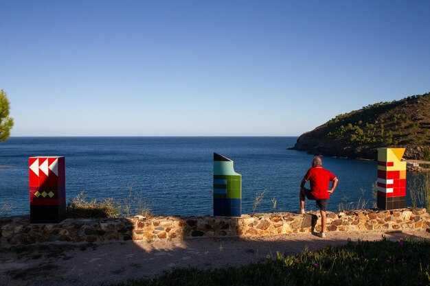
As you head toward the southern coast, drop anchor near Cagliari’s historic harbor and wander the maze of alleys in the Castello district, with nearby tavernas offering fresh seafood. A morning market, a lunch of bottarga, and an afternoon sail toward Villasimius or Costa Rei deliver exceptional scenery and calm water. For a final touch, anchor near Portoscuso at sunset and observe the rocky headlands glow.
With a number of routes and time-saving options, this itinerary fits a range of wind patterns and sea states. Where you anchor, nearby towns invite you to stroll the waterfront, sample seafood, and plan a second visit. The southern leg reveals a different mood–hushed coves, rugged cliffs, and sunsets that feel like a pearl in a marine canvas. If conditions shift, habe a backup plan and adjust to a sheltered bay; the day doesnt have to follow a rigid map, and that makes the route truly intriguing.
Sardinia Sailing Itinerary
Begin with La Maddalena archipelago for a sheltered, special start that yields easy anchorage and a network of marinas.
-
Day 1: Olbia to La Maddalena archipelago
- Sail along the northeast coast into protected waters, choosing Cala Gavetta or Cala Spalmatore for a calm first mooring.
- Explore the medieval town of La Maddalena and Caprera, soaking up the ambience and recording a few clear waypoints for them to reference later.
- Ask giuseppe at the marina for help with weather checks and the best routes along sardinias coast.
-
Day 2: La Maddalena to bonifacio ( Corsica )
- Cross the pass to bonifacio, watching for currents between Sardinia and corsica.
- Dock in the francese-influenced harbor, where the backdrop of white cliffs and ancient walls frames a striking scene.
- While you stroll the old town, enjoy fresh seafood and the quiet ambience before the next leg.
-
Day 3: bonifacio to lavezzi
- Head toward lavezzi, a protected marine area with small, intimate anchorage options among the islets.
- Keep to short hops between coves to minimize wake and maximize sheltered time in crystal water.
- Use a mark on the chart for a late-afternoon stop and enjoy the stillness above the seabed.
-
Day 4: lavezzi to southeast Sardinia ( Villasimius / Costa Rei )
- Proceed southeast along the Sardinian shore, selecting a stop in Villasimius or the Costa Rei marinas for a lively yet protected base.
- Enjoy the ambience of seaside taverns and local shops, then settle into a quiet anchorage for the night.
- Note how the coastal roads frame distant hills, giving a sense of continuity between sea and land.
-
Day 5: Villasimius to Cagliari
- Slip into Cagliari’s marinas, where a sheltered harbor awaits and town life is an easy reach by tender.
- Stroll through the Bastion and marina area, sampling seafood and pausing at shops along the water’s edge to mark souvenirs.
- Keep a flexible schedule to catch a sunset over the Poetto backdrop, then rest in a protected anchorage nearby.
-
Day 6: Cagliari to Golfo di Orosei (Ogliastra)
- Chart a course north to the Gulf of Orosei, with standout anchorages near Cala Luna or Cala Goloritzè when conditions allow.
- In the afternoon, drop anchor near secluded coves and savor the marine clarity and rugged coastline.
- Adjust plans if seas rise; this segment rewards patience with calmer water and dramatic scenery.
-
Day 7: Golfo di Orosei to Olbia or return loop along sardinias east coast
- Return toward Olbia by following the east coast’s bays and roads, stopping at a final anchorage to celebrate the week.
- Review the chart, make notes for a future mark, and reflect on the week’s highlights across the Sardinian coast.
Last-leg start point, optimal departure time, and routing for Friday
Depart Cala Gavetta, La Maddalena, at 08:50 local time. Sail northeast along the protected front of the maddalenas archipelago, avoiding the lavezzi shoals to the south, and steer toward Porto Cervo to follow the coast. This choice delivers a scenic, dazzling backdrop of cliffs, coves, and shimmering water, with the afternoon sun creating beautiful color on the shorelines.
Distance Cala Gavetta to Porto Cervo: 40-45 NM. Target 6.5-7.5 hours at 6-7 knots; ETA around 15:20–15:45. Mark Capo Ferro as the turning point, then continue along the coast to Porto Cervo marina for a lunch and fuel break before the next leg.
Porto Cervo to Olbia leg runs 25-30 NM in 4-5 hours at 6 knots, with an ETA near 19:30–20:00. Dock Olbia by 20:00, enjoy dinner ashore at a locally-sourced spot, and let the community vibe set the tone for the final evening. The route keeps you close to sheltered coves and ports along Costa Smeralda, exposing a beautiful and shimmering maritime backdrop.
For years, geduldig weather checks help you stay in protected waters, and hatten gusts often ease by the afternoon. If wind shifts, shorten the leg to Porto Cervo or swing directly into Olbia’s outer harbor; also keep a backup stop at Golfo Aranci. Carry a small book for notes on marks, tides, and timings. This plan pairs maddalenas charm with Olbia’s ports, presenting two worlds of beauty and practicality, and ends with a dinner that highlights locally caught seafood.
Final-night mooring options: harbors, tides, and docking tips
Pick a protected harbor for your final night–Olbia or Golfo Aranci are solid, easy-to-reach options that keep seas calm and docking straightforward. This choice will give you quick access to water, fuel, and a delightful boutique dining scene, plus a center of shops and caprerabudelli tasting rooms along the quay. The utmost priority is shelter from swell, so prioritize harbors with solid breakwaters and marina staff who can help if you arrive after hours.
If you crave a coastal cruising vibe while staying sheltered, target inner harbors such as Porto Rotondo or Santa Teresa di Gallura. The guardia costiera can confirm slip numbers and tide windows, and many harbors offer reserved berths for late arrivals. On Tuesday and Saturday evenings, some marinas report lighter traffic, which makes final-night stays calmer and easier. From these places you can stroll to intriguing waterfront boutiques and enjoy a glass of local wine. Some locations also offer caprerabudelli tastings and other small delights you can savor after docking.
Tides in Sardinia stay modest, but you still need to time your approach. Plan arrivals near slack water if possible and verify with the marina center before you depart, as a calm entry reduces risk of contact with other vessels. Use the local tide table and wind forecast to predict swells above the quay; this information helps you select the best berth. A quick check at the center will also help you locate a protected slip near the center of the marina.
Docking tips for the final night: approach slowly from the seaward side, align with the fingerprint, and keep a short, steady swing if gusts arrive. Deploy soft fenders and angle two lines to bow and stern cleats, plus a spring line to control drift. Call the guardia or the marina office when you’re five minutes out so staff can guide you to the right slip. In protected harbors, berths are available for visiting yachts; verify depth and clearance with the dock master before you tie off. In most harbors, berths accommodate average cruising yachts; confirm the slip size with the center desk to ensure a smooth fit.
After you secure the boat, stroll to the quay for a breathtaking sunset and a delightful finale. Watch for creatures–seabirds and crabs skittering along the pilings–and savor hatt en pastries with caprerabudelli at a sea-front boutique. This experience, from the intriguing market to the quiet harbor lights, offers a memorable end to a coastal cruising itinerary. vivre the moment, this final night in Sardinia will stay with you long after you depart the places you visited.
Weather, wind shifts, and safety checks for Day 7
Check the 48‑hour forecast and set a contingency plan for wind shifts on Day 7, then secure one reliable mooring in a protected bay before the first gust arrives.
Day 7 runs along the northeast side of Sardinia with Corsica nearby; the mediterranean breeze shifts through the day, and funnel effects between headlands can tighten gusts. Corsica boasts rugged coastlines and famous rock formations that concentrate wind in narrow channels, so expect wind shifts near shore and gusts that can surprise a line of moorings. The francese coast adds micro‑currents that can alter boat speed on small triangles of water, so plan for changes that affect both sides of the boat.
In the morning, anticipate a northeast tilt around 12–18 knots, rising to 18–25 knots by midday, with occasional bursts to 28 knots in sheltered channels. By late afternoon the wind can back toward the southwest or west as thermal heating builds, which changes the sail plan and requires quick reefing. Those shifts create brief lulls suitable for sunbathing on deck, but they also demand steady vigilance when approaching rocks, bays, and protected harbours that often double as sheltered flotilla moorings.
Safety checks flow from the forecast into action: verify that all crew members wear life jackets when gusts sharpen, secure harness lines for those on deck, and keep a tether ready near the helm. Maintain a ready weather watch with VHF on channel 16 and a backup handheld radio, because timely alerts save moments if a shift comes quickly. Conduct a quick engine check and confirm steering responsiveness, bilge pump readiness, and sail‑trim reef lines; changed conditions require fast sail alterations and clear communication among crew on every person onboard. That thats why a compact, practiced routine matters more than a lengthy plan.
Quando pianificate manovre vicino alla costa, individuate in anticipo le zone protette e prendete nota di quali sono adatte alla strategia di ancoraggio della flottiglia. Le calette più famose offrono acque calme per le pause di sole, ma solo dopo aver verificato la protezione da corrente e cambi di vento. Utilizzate ormeggi segnalati e approcci consolidati in quelle aree protette per ridurre i rischi per il gruppo e tenete d'occhio le mani di terzaroli e le cenge rocciose che formano lati pericolosi se le previsioni peggiorano.
| Elemento di controllo | Details | When |
|---|---|---|
| Variazioni meteorologiche e di vento | Vento moderato NE 12–18 kt al mattino, raffiche a 28 kt nei canali; prestare attenzione ai cambiamenti verso SW/WSW a fine giornata; effetto imbuto vicino alle coste della Corsica | Dal mattino al pomeriggio |
| Ormeggi e piano flottiglia | Confermare baie protette, verificare ormeggi disponibili, pre-allacciare i parabordi, coordinare la gestione delle cime per più imbarcazioni | Before departure |
| Dispositivi di sicurezza | Giubbotti di salvataggio per tutti gli ospiti, imbracature pronte, dispositivo galleggiante di salvataggio, radio VHF cariche | Prima della partenza e durante il viaggio |
| Navigazione e comunicazioni | Carte delle zone di canalizzazione della Sardegna nord-orientale e della Corsica; controlli AIS/GPS; ascolto canale 16 | Morning |
| Sistemi per imbarcazioni | Controllo motore, sterzo, terzaroli, prova pompa di sentina | Prima di salpare |
| Crew readiness | Assegnare ruoli per i cambi di vento, confermare i compiti di gestione delle cime, informare sulla protezione solare e l'idratazione. | Prima di salpare |
Waypoint di navigazione: rotta precisa, punti di riferimento e tempistiche per la navigazione di venerdì
Partenza dal porto turistico di Alghero alle 08:00, rotta 306° lungo la costa occidentale, mantenersi a 1 NM dalla costa per sicurezza e per mantenere gli uccelli marini a prua. Utilizzare questi waypoint per mantenere una rotta precisa, con controlli dei punti di riferimento e finestre ETA adatte a una giornata in mare rilassata ma efficiente.
- WP1 Faro di Capo Caccia – distanza 9 NM, rilevamento 306°. Riferimento: faro bianco arroccato sulla scogliera; il promontorio appariva spettacolare mentre l'alba illuminava la roccia. ETA 09:30 a 5,5–6,0 nodi. Note: passare a 0,8 NM dalla costa per evitare scogli; regolarsi in base ai cambiamenti di vento.
- WP2 Ingresso ovest Isola Piana – distanza 8 NM, rilevamento 288°. Punto di riferimento: Isola Piana con bassi fondali all'avvicinamento. ETA 11:00; velocità 5.5–6.0 nodi. Note: confermare acque sicure con ecoscandaglio; fare attenzione alle lenze dei pescatori in prossimità dell'acqua stagnante.
- WP3 Promontorio di Porto Conte – distanza 6 NM, rilevamento 296°. Punto di riferimento: promontorio coperto di pini, con il piccolo porto turistico di Porto Conte in vista. ETA 12:15; velocità 5.5–6.0 nodi. Note: acque riparate più avanti; prepararsi per la pausa pranzo se necessario.
- WP4 Cala Reale Cove – distanza 5 NM, rilevamento 281°. Punto di riferimento: la spiaggia di sabbia bianca della cala, incastonata tra le scogliere; ideale per una pausa di sole di base. ETA 13:45; velocità 5.0–5.5 nodi. Note: ancoraggio o ormeggio sul lato ovest; controllare la corrente di marea.
- WP5 Avvicinamento a La Pelosa (Torre della Pelosa) – distanza 14 NM, rilevamento 265°. Punto di riferimento: Torre della Pelosa e iconica spiaggia bianca. ETA 16:00; velocità 5.5–6.0 nodi. Note: prenotare un ormeggio se il vento cambia; il tramonto sull'acqua è spettacolare; sosta facoltativa per una nuotata o una visita alle luci del resort per un momento clou serale.
La rotta offre scogliere architettoniche, come Capo Caccia, e un fascino così aspro che la costa sembrava particolarmente invitante. Il vento da ovest ti ha aiutato a navigare agevolmente lungo la costa, al di là della semplice navigazione a vela, fino a un'estremità tranquilla e panoramica a La Pelosa. Questo piano mantiene tutti comodi e al sicuro a bordo, con le considerazioni relative all'assicurazione e al noleggio verificate prima della partenza. Se una riunione viene spostata a martedì, modifica gli orari di circa 30 minuti per accogliere tutto l'equipaggio e mantieni la tabella di marcia serrata per tutti i soggetti coinvolti. Le prospettive includono bagni di sole, uccelli marini che volteggiano sulla prua e una serata che risuona del fascino della Sardegna nord-occidentale: momenti salienti che tutti possono apprezzare, visitare e ricordare intorno al promontorio, con le vele salde e gli spiriti alti.
Finale a terra: ristoranti, punti panoramici per il tramonto e opportunità fotografiche dopo l'attracco
Getta l'ancora in un porticciolo riparato e raggiungi a piedi una terrazza ristorante sul lungomare per una superba cena di pesce d'ispirazione francese che rende il finale a terra davvero eccezionale. I porticcioli lungo la costa offrono opzioni simili, quindi puoi scegliere l'atmosfera che preferisci.
Scegli una terrazza di sabbia vicino al porticciolo dove hai un bagliore verde dalle lanterne e una vista diretta sull'acqua. Nei porticcioli della costa sud-orientale italiana, cerca locali che uniscano giardini lussureggianti con la brezza marina; ordina un'orata alla griglia con limone e una beurre blanc alla francese, poi concludi con una panna cotta. Un Vermentino secco della regione si abbina meglio di un rosso corposo, soprattutto dopo una traversata in mare aperto. Come consiglio, suggerisco di scegliere un tavolo con riflessi sull'acqua.
Luoghi al tramonto: Per il tramonto, scegliete un promontorio verde lungo la costa sud-est o la banchina occidentale del porto turistico, dove i colori delle stelle sbocciano e le viste si estendono verso mondi lontani. Gli appassionati di fotografia apprezzeranno le lunghe silhouette e la luce soffusa.
Opportunità fotografiche dopo l'attracco: cattura i riflessi dello scafo sulla banchina, incornicia l'antica torre di guardia dietro la costa lussureggiante e usa l'ancora come silhouette contro l'acqua scintillante. Scatta esattamente durante l'ora blu dall'estremità del molo verso sud-est per includere alcuni punti stella e i mondi in lontananza.
Trascorri le ultime ore con il tuo skipper e una manciata di marinai; condividono suggerimenti per angolazioni e tempistiche migliori. Fai una breve passeggiata verso i punti panoramici di Capo lungo il bordo del promontorio per scatti spettacolari, oppure rimani sul molo se preferisci la luce dei porti turistici. Se vuoi nuotare, scegli un'insenatura riparata; le brezze al largo mantengono l'aria fresca mentre si accendono le luci.