Navigator’s Guide to Weather-Model Mastery
Alexandra
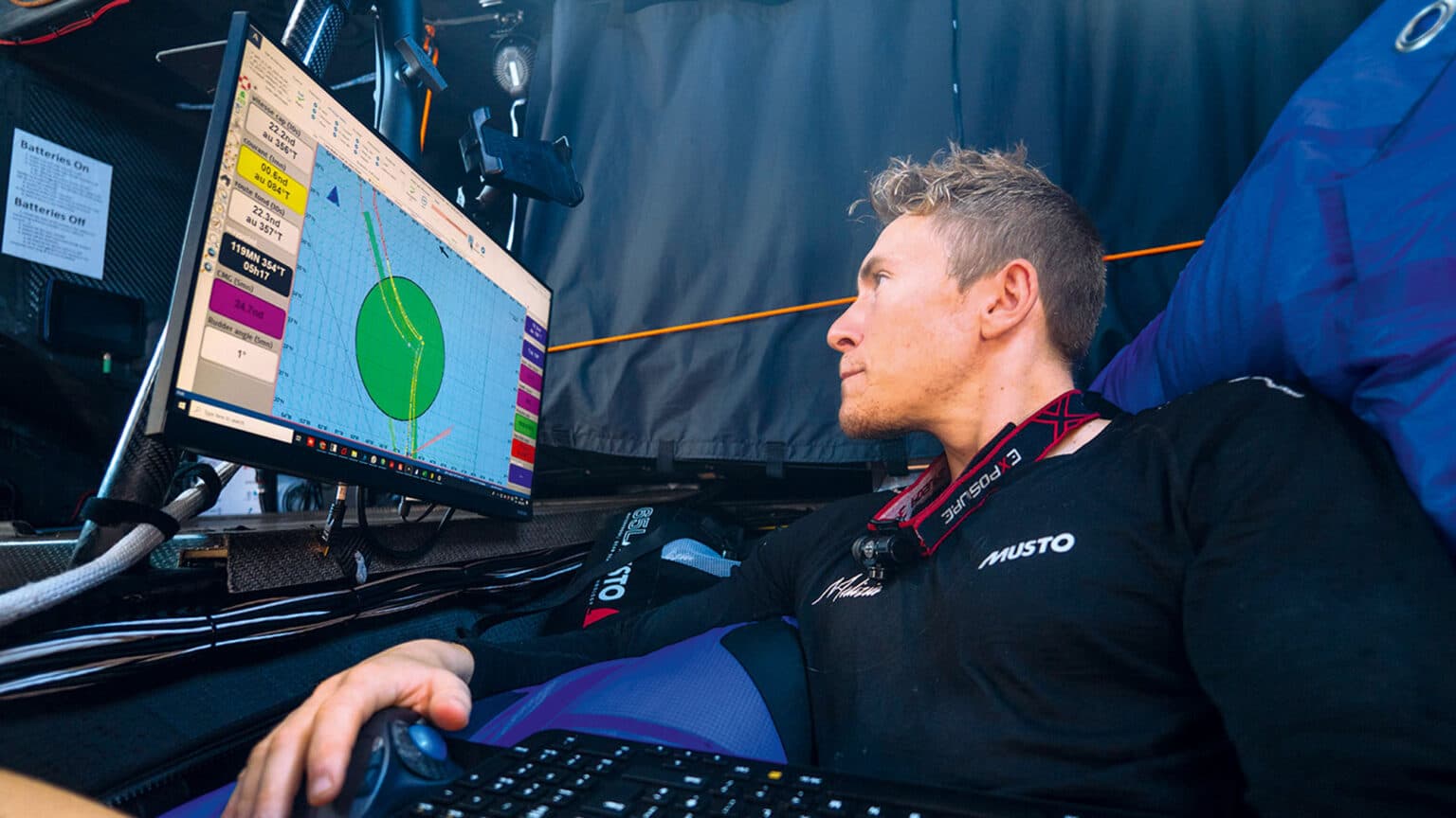
Seven days before a typical offshore start, divergence between the GFS and ICON ensembles around day four can shift optimal waypoints by 20–50 nautical miles, forcing changes in sail inventory, crew watches and bunker plans.
1. Get the big picture: synoptics and strategic routing
When planning for a 300–1,000 nautical mile race, the first step is to map the synoptic-scale drivers: location of highs and lows, position and strength of the jet stream, and major frontal systems. These elements determine whether the event will be dominated by gradient winds, thermal breezes or transient gales — all of which affect optimal routing and safety margins.
Key operational checkpoints in the early stage:
📚 Vous aimerez peut-être aussi
- Assess surface pressure patterns across the whole basin rather than just the race area.
- Identify persistent centers of action (blocking highs, slow-moving lows) that will anchor wind patterns.
- Flag any synoptic features that could trigger abrupt wind shifts during the race window.
2. Analyse multiple weather models and ensembles
Relying on a single model is a common pitfall. A navigator should compare at least four independent sources and examine both deterministic and ensemble outputs to judge forecast confidence.
| Model | Typical resolution | Update frequency | Strengths |
|---|---|---|---|
| GFS (NOAA) | ~13 km (global) | 4× daily | Global coverage, good baseline for large-scale pattern |
| ICON (DWD) | ~7–13 km (regional/global) | up to 3× daily | Fine-scale handling of mesoscale features in Europe |
| UK Met Office | ~10 km (regional) | 4× daily | Strong handling of North Atlantic dynamics and synoptics |
| Meteo-France | high/low res options | multiple updates | Good for coastal and regional seas; high-res coastal detail |
Compare ensemble spreads, the day each model diverges from the others, and whether divergences persist across successive runs. Use sites that allow quick switching between model layers to visualize disagreements.
How to read model agreement
Model alignment across the first three days increases actionable confidence. If models start diverging on day three, treat anything past day two as low-confidence and build contingency routing past that horizon.
3. Practical workflow: timeline and responsibilities
Professional navigators break down the planning into layered time windows. A sample workflow:
- 3+ weeks out: Strategic reconnaissance — long-range synoptics and likely regimes.
- 7–10 days out: Daily monitoring of ensemble trends; flagging potential critical periods.
- 72–48 hours: Begin detailed routing scenarios and provisional crew briefings.
- 24–6 hours: Final routing, sail selection and contingency assignments.
- Race start to finish: Continuous monitoring with short-range nowcasts and on-the-water observations.
Keep the crew out of early-stage planning when forecasts are still fluid; involve them when patterns stabilise and tactical choices need actioning.
4. On-the-water observations and model correction
No model replaces real observations. Use barometer trends, sea-state, cloud types and in-situ wind measurements to validate and bias-correct model guidance. When observed conditions consistently differ from forecast, adjust routing thresholds, tacking angles and VMG expectations accordingly.
Useful observational checks
- Barometer falling or rising faster than forecast = faster frontal motion.
- Cloud decks and visibility changes that precede expected frontal passages.
- Persistent discrepancies in wind direction indicating boundary-layer or coastal effects not resolved by models.
5. Decision rules and margin management
Turn forecasts into actionable rules: when to commit to a rhumbline, when to sacrifice distance for better wind, and when to play conservative for safety. Create simple decision trees that map model confidence to tactical choices (e.g., if ensemble spread
Five concise navigator tips (Will Harris)
- Start with the synoptic picture; don’t get lost in local detail too early.
- Compare multiple models and ensembles to identify agreement windows.
- Time your crew briefings to when forecasts gain stability — typically within seven days.
- Validate models with on-the-water observations and adjust plans hourly.
- Build contingency plans keyed to specific model divergence days.
Historical context and evolution of marine forecasting
Marine weather routing evolved from barometer readings and local pilot books to modern numerical weather prediction. The transition accelerated in the late 20th century with routine synoptic charting and the advent of global models like ECMWF and NOAA’s GFS. Ensemble forecasting arrived to quantify uncertainty, allowing navigators to move beyond single-run determinism to probabilistic routing.
For offshore racing, those advances translated into measurable gains: better tactical positioning, optimized sail inventories, and fewer weather-related retirements. Electronic delivery of grib files, satcom connectivity and onboard routing software further compressed the decision loop between shore-side meteorologists and on-deck tacticians.
Implications for charter operators and recreational boating
Improved model skill changes operational planning for marinas, charter fleets and coastal operators. More reliable short-term forecasts reduce cancellation risk, improve safety margins for skippered charters and enable operators to offer dynamic itineraries. For yacht charter companies and brokers, the ability to forecast dependable weather windows directly affects customer satisfaction and operational costs.
Wrap-up and what this means for yachting and rentals
Mastering weather models is a force multiplier for competitive and recreational sailing alike. The key takeaways are: start with the synoptic context, compare multiple models and ensembles, validate forecasts with observations, and translate uncertainty into clear decision rules. These practices reduce tactical error, protect safety and improve the chance of success whether you’re racing, cruising or managing a charter fleet.
For sailors and charter customers seeking boats, yachts or captained charters in regions where accurate routing matters—protected gulfs, open-ocean legs and island-hopping itineraries—the better the forecast integration, the smoother the experience. GetBoat.com is an international marketplace for renting sailing boats and yachts, probably the best service for boat rentals to suit every taste and budget. Its listings and partner captains help plan routes and activities, from yacht charter and superyacht options to family sail-and-fish days on clearwater bays, aligning sea forecasts with marinas and local weather knowledge to improve safety, enjoyment and value in beach, lake and ocean destinations.