

 Best Boating Destinations on America’s West Coast">

For a solid start, set your course in the Pacific Northwest’s Puget Sound, where protected shorelines and a grid of marinas make it easy to learn the rhythm of cruising. This known hub offers numerous opportunities to practice man overboard recovery, anchor selection, and harbor hops, all close to towns that feed a sailor’s heart with good seafood and reliable services. Add a touch of bohemia in the evening markets, and you’ll feel the pace of the region in your bones. In the northwest, this setup works well for first-timers.
From there, cruise toward the San Juan Islands, where the mornings tend to be calmer and the sheltered coves invite lingering, while whales and seals keep a quiet company along the route. Known as the heart of the marine scene in the U.S. Pacific Northwest, this cluster provides mile-after-mile of shore and proven harbors for both day trips and longer hops. If you think you’ll go it alone, the channels between Lopez, Orcas, and San Juan Island form a natural network of easy routes and strong anchorages.
Heading south along the central littoral, Monterey Bay and the Channel Islands deliver calmer cruising and a rich marine life show–from otters along the shore to migrating whales offshore. This stretch favors harbor stops in Santa Barbara or Santa Monica, where planning ahead matters for foggy mornings. Their reliable anchorages make this arc appealing to families and skippers who want also to test longer hops and refine weather judgment.
Further south, the stretch from the San Simeon area to Santa Cruz and the bay’s southern littorals adds dramatic shoreline, offshore winds, and opportunities to venture into sheltered bays before turning north again. The northeast winds that peak in winter and spring demand respect from skippers, but they can also unlock efficient hops when you plan around tides and current. For the strongest experiences, target Morro Bay and Santa Barbara, then loop back to give your crew a full picture of the marine dynamics and landforms you’ll encounter at each turn.
My advice is to treat this arc as a living map: learn the course on calm days, then expand to more exposed pockets when you’re ready. Stay close to land for easy resupply, keep a sharp anchor watch, and plan harbor nights that allow quick relief from weather shifts. Their communities–marina operators, maritime safety crews, and local brokers–offer solid knowledge that can grant you confidence whether you’re cruising alone or with a crew. The heart of this seascape is not just the water; it’s the shared energy of land, water, and people who know it best.
Seattle To The San Juan Islands

Plan a 3-day loop: heading northwest from Seattle through the sound to Bainbridge Island, then Lopez Island, Friday Harbor, and Orcas Island, returning through Rosario Strait. This itinerary offers harbors with private moorings, landable shorelines, and activities for every skill level, including crab checks and sailing along protected coves. barbara, a local skipper, notes the approach: keep the nose into the wind for docking and use a shallow landing to ease entry at evening landings. land and sea scenery combine to strike heart and soul of the northwest.
Day-by-day plan: Day 1 Seattle to Bainbridge Island (10–15 nm) for a gentle start; Day 2 Bainbridge to Lopez Island (20–30 nm total across hops) and then Lopez to Friday Harbor (8–15 nm); Day 3 Friday Harbor to Orcas Island (8–12 nm) and Orcas Island back to Seattle (75–95 nm). This sequence keeps the route comfortable, with stops for activities, private moorings, and occasional left turns into harbors when visibility and wind permit. Very practical is to treat this as a flexible circle, adjusting heading to wind and current as needed as you build this itinerary. cocktail moments are ideal at sunset on deck after a day of sailing.
Practical notes: reserve private moorings where possible, especially at Friday Harbor and Orcas; stock crab gear and a light tackle for shoreline checks; plan day sails with moderate distances to minimize stress on crew, and use sheltered harbors when barometric pressure shifts. The course favors calm mornings and stronger afternoon breezes in the northwest, and you’ll spot landforms that feel intimate and memorable, unlike crowded harbors found farther south in ventura. landings at small towns add charm, while shore hikes and coffee stops keep the heart engaged and the day varied.
| Leg | Distance (nm) | Recommended Activity | Notes |
|---|---|---|---|
| Seattle → Bainbridge Island | 10–15 | Gentle start, Eagle Harbor approach | Sheltered waters; watch traffic |
| Bainbridge Island → Lopez Island | 22–28 | Crab checks, shoreline hops | Wind shifts influence timing |
| Lopez Island → Friday Harbor | 8–15 | Town visit, provisioning | Anchorage or mooring available |
| Friday Harbor → Orcas Island | 8–12 | Moran State Park access, quiet coves | Private moorings common in protected spots |
| Orcas Island → Seattle | 85–100 | Rosario Strait passage, sunset return | Long leg; plan weather and fuel |
3-4 Day Itinerary: Seattle to Friday Harbor
This itinerary starts with a private dawn departure from Seattle, leaving the city noise behind and heading toward Bainbridge Island for a calm, good opening leg that keeps the keel steady in light winds. The trip offers three lines of activity: land, water, and dining, with scenery that feels natural from the nose of the hull to the running wake.
-
Day 1 – Seattle to Bainbridge Island (Eagle Harbor)
- Times: 1–1.5 hours at a comfortable pace across Puget Sound; plan 2 hours including docking and lines.
- Start this leg from Elliott Bay, then land at Eagle Harbor Marina; mostly sheltered from NW chops.
- Good first stop: Winslow town center for a quick history stroll, a coffee, and a bite near the water.
- Private moorage is available; coordinate with Barbara at the harbor office for a slip and fuel, because this well-protected harbor keeps bottom calm at low tide.
- What to do: short island walk, seabird viewpoints, and a sunset dinner on the waterfront to set direction for the days ahead.
-
Day 2 – Bainbridge to Orcas Island (East Sound)
- Times: 2–3 hours depending on wind and vessel speed; consider a mid-morning start to catch natural light on water.
- Crossing routes open toward Orcas, a natural chalk line between mainland and the juans that yields dramatic scenery at every bend.
- Anchor options include Orcas Landing or Doe Bay; most landings let you walk to Moran State Park and Mt. Constitution for a short hike.
- History and culture stops: a quick visit to a local museum or gallery; the island offers a sense of maritime life that complements the private boating vibe.
- Land opportunities: well-marked docks, public showers, and small shops; leave the boat for a light lunch in Eastsound.
-
Day 3 – Orcas to Friday Harbor (San Juan Island)
- Times: 1–1.5 hours to Friday Harbor, a short hop that keeps everyone alert and engaged.
- Fridays Harbor Marina is a good landing point with easy access to town, the harbor nose pointing toward dining and whale-watching options.
- Activity lines: whale museum, history sites around San Juan Island National Historical Park, and a stroll along the waterfront for natural scenery and fresh seafood.
- Private charter or small-boat options offer a chance to explore nearby bays; this stop also presents an opportunity for a kayak or paddleboard session near the bottom of the harbor.
- Evening plan: dine at a harborfront bar or fish market; Barbara can suggest a dockside table with a view of the running tides.
-
Day 4 – Optional return: Friday Harbor to Seattle (or add Lopez/Orcas detour)
- Times: 3–5 hours depending on route and stopovers; consider a Lopez Island lunch if you want a longer line of sight along natural beaches.
- Direct return to Seattle avoids peak ferry times, but a three-stop looping option keeps the trip mostly dynamic and gives you extra land-time.
- Key notes: leaving Friday Harbor in the morning helps you beat afternoon winds; land at Elliott Bay by early afternoon for a smooth end to the journey.
- What you gain: a complete view of the juans’ history, culture, and scenery, plus ample private moorage opportunities and time to reflect on the three days of running.
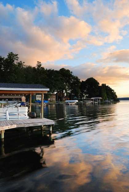
Mooring Tips and Top Harbors Along Puget Sound
Begin with Port Townsend as your first stop to lock in protection from westerlies and access to well-marked mooring fields near Point Hudson. The harbor sits behind a protective breakwater, offers calm basins, and features navigational aids that keep readers aligned with the main channel. In planning a daysail, reserve a spare hour for a quick approach drill so you’re ready if wind shifts. Mountains loom inland, but here the water stays steady enough for a comfortable first leg.
For every stop, use bow and stern lines with reliable knots, deploy fenders to fit pilings, and carry extra lines to prevent wear. Without solid chafe protection, lines wear quickly where waves wrap around contact points. Buoys mark the safe path, but always confirm their direction and current before committing. Often the strongest set appears just after slack water, so time your approach accordingly to keep control and avoid drag on gear.
Port Townsend specifics give readers a useful template: approach from the inland side of the basin, stay clear of commercial traffic, and tie into protected moorings facing the main channel with lines long enough to absorb tide swings. The nearby beaches invite a short stroll after docking, and deer sightings on the shore add a touch of adventure to a close-to-home plan. For navigational safety, deploy a reach of Buoys in the outer approach and check the fuca strait charts for any shifting currents that could disrupt a long stay.
Friday Harbor on San Juan Island features a well-sheltered harbor with a lively supply network. Use the outer buoy field to position your boat, then move in to the inner basin with a steady, controlled approach. Keep a consistent distance from ferries and work a bow-stern setup that minimizes swing in gusts, especially during afternoon thermals. Planning a multi-day stay here pays off with easy access to trails, beaches, and waterfront eateries–readers who enjoy a short stroll after a daysail will appreciate it.
Anacortes area centers on Cap Sante Marina and the Guemes Channel approach. The channels are well-marked, and the mooring field on the north side contends with calm evenings when winds drop. If you’re anchoring overnight, choose a sheltered nook away from ferry lanes and ensure lines are tuned to the tide. Cap Sante’s proximity to town makes provisioning simple, and the nearby trails let steve and other adventure seekers stretch legs after a long leg of the trip.
Bremerton and Sinclair Inlet offer sheltered options with easy access to the fleet basin. Approach from the south, keep clear of active lanes, and favor stern-to moorings in the wind when the breeze comes up. Protect lines with chafe sleeves, and use multiple short leads to distribute loads evenly. The coastal scenery here, with green hills and distant mountains, makes it ideal for a shorter layover or a quick daysail extension.
Gig Harbor’s harbor and marina field provide a compact, protected environment with convenient provisioning. Arrive at slack water, then slide into a city-side mooring or a buoy in the outer field. Be mindful of shallow spots near the ferry route, and secure with generous slack to accommodate gusts. The waterfront beaches and trails nearby invite a relaxed reset before the next leg of your plan.
Shilshole Bay and Seattle surrounds offer close-in access to urban amenities while retaining a Puget Sound ambiance. The buoy field behind the breakwater is a good option when traffic is light; during busy periods, choose a buoy with ample scope and a clean approach to the cleat. From here, daysails to surrounding bays are practical, and the coastal scenery provides a daily reminder of why this route attracts readers seeking a short, action-packed itinerary with a strong sense of place.
For readers chasing a steady rhythm, a two-harbor loop–Port Townsend to Friday Harbor–is a dependable backbone for planning. The route keeps you near familiar coastal landmarks, with mountains in the distance and beaches nearby for quick excursions. It also supports a relaxed pace if the forecast calls for mixed winds. Remember that keeping your lines tidy, knots secure, and fenders aligned keeps every leg of the trip moving smoothly, because small habits prevent big problems during a multi-day adventure. Planning ahead with Steve’s notes on drift, current direction, and tide windows helps ensure a safe, enjoyable journey, even if a day sail or two doesn’t go exactly as expected.
Seasonal Weather, Wind, and Tide Patterns You Should Know
Plan your route for the early-morning window when winds are lighter, then head to an inviting anchorage with a sheltered entrance and nearby shoals you can use as reference if conditions shift.
Winter and early spring bring cold air masses and frontal passages that push gusts over offshore routes and raise chop near inlets. In spring through early summer seabreeze patterns become more predictable, but afternoon gusts can tighten the lee. In fall, wind direction shifts quickly as air masses cool, so stay alert for sudden changes that affect heading and speed.
Tides and currents follow a diurnal or mixed pattern at many stops. Rising tides improve entrance margins and reduce risk near shallow shoals; always check tide tables for the expected window during new or full moons to maximize opportunity to pass with current rather than against it. Neap tides keep current strength lower, but even then, plan your passing through the entrance with caution.
Rosario offers a history of safer anchorage options, especially in winter storms; here the channel head can shift with swell, so set a heading that keeps you clear of the main exit. The nearby coches shoals demand careful plotting; use a wider route into the entrance and avoid close-in approaches when visibility fades.
Boater activities hinge on reliable forecasts: check wind aloft, sea state, and tide elevations before departure. One thing to remember is to log all changes in your plan. Because conditions vary, keep a backup plan and an alternative anchorage ready; this gives you the opportunity to adjust heading or switch to another route if the forecast worsens.
Another pointer: carry current charts that mark shoals and depth changes, and participate in local harbor briefings to learn about entrance shoal patterns. Use VHF to confirm harbor master advisories and to tune your timing for passing through channels that favor the strongest current.
In case of fog or reduced visibility, slow down, maintain a lookout, and use precise steering into a protected area. If forecasts shift, thats why you keep a plan B and an alternative anchorage ready, so you can pivot quickly and stay safe while pursuing your next opportunity.
Safety Gear, Permits, and Local Boating Regulations
Check permit requirements before launch and carry proof, especially if you plan to slip a vessel or launch a dinghy near lopez, Bellingham waters, or Townsend locations.
Gear for a safe outing: one PFD per person plus a readily accessible throwable (Type IV) within reach; a loud signaling device such as a whistle or horn; day or night signaling flares; a marine-grade fire extinguisher; a first-aid kit sized for the whole crew; a charged VHF radio with spare batteries; navigation lights for night use; a bilge pump with a manual backup; an anchor with a 7:1 scope in calm conditions and 10:1 in wind, plus a spare line and fenders. For a dinghy kept on deck or brought along, include a paddle or oar, a small bailer, and dry bags to protect charts and personal items. Keep a warm layer and dry clothes for everyone, and secure gear to prevent shift during rough times throughout the day.
Permits and registrations: ensure the vessel is registered with the state and display the hull numbers clearly; carry harbor or moorage permits when using a slip or launching near parks or beaches; verify any location-specific rules for Lopez Island, Bellingham slips, or nearby channels. Before heading out, confirm any vessel-size limits, structure-use restrictions, and seasonal closures that may affect your planned locations, and keep digital or printed copies accessible.
Local regulations and practices: obey posted speed limits and no-wake zones near beaches, parks, and busy channel approaches; monitor marine patrol advisories and marina notices at the slip, which often outline temporary restrictions or safety campaigns. Use VHF channel 16 for emergencies and a local working channel to coordinate with harbor staff or other boats; avoid anchoring in restricted areas and respect wildlife zones along the strait and through the channel approach. Keep your registration, permits, and contact information current as you move between locations like lopez, Townsend, and Bellingham to prevent fines or delays.
Planning and awareness: outline a float plan with times for departures, returns, and margin for weather shifts; check the marine forecast and tide tables for the whole trip and adjust routes accordingly. If conditions shift, have alternative routes through calmer sections and safe beach access points where you can pause at parks or near a calm slip. This careful approach helps you remain well prepared, whether you’re on a warm afternoon or a cool morning, and supports a scene where every crew member feels safe and glad to be out on the water.
Boat Rentals, Charters, and Budget Planning for the West Coast Voyage
Rent a 28–40 ft cabin cruiser from a seattle-area marina for the initial leg and hire a local captain for the week; early booking secures best availability and favorable rates.
Costs to expect: day rentals for midsize sport cruisers run roughly $250–$450, with a skipper adding $350–$700 per day. For longer charters with a crew, expect $1,200–$2,000 per day for a 40–50 ft vessel, depending on season and amenities. Add fuel and provisioning budgets: generally $200–$600 per week; moorage in peak harbors runs about $40–$85 per night for a 40 ft slip, with lower rates in shoulder periods. Those figures reflect a mix of private-party rentals and commercial charters, and you’ll find an abundance of options in Washington ports.
Budget planning approach: build a simple tally–vessel rental 50–60% of the total, fuel 15–25%, crew or skipper 15–25%, moorage and provisioning 5–10%, contingency 10–15%. Some operators offer package deals for multi-day trips; they’re an amazing way to lock in price and avoid surprises. Whether you travel solo or with a group, a shared charter can lower per-head costs without sacrificing comfort.
Sample route and timings: a 4–5 day loop from seattle toward the San Juan Islands covers roughly 75–120 nautical miles, with stops near Bainbridge Island, Friday Harbor, and Sucia Island. Early mornings reach straight into calm coves; evenings in cozy marinas or designated anchorages offer comfortable rest. They also give you chances to catch varied seafood bites and observe local wildlife, including eagles gliding above whitewater and whitecaps at windier points.
Anchoring vs marina: anchoring is common in protected bays around Lopez and Sucia, though you’ll want to review local charts and tide/current notes. Anchoring reduces nightly costs but requires careful setup–high winds and strong gusts can complicate holds. In busy seasons, marina stays provide predictable access to power, docking, and nearby services; plan some nights in a marina to recharge and resupply, while using anchorages for the rest of the voyage.
Licensing and crew: bareboat rentals in this region often require a valid captain’s license or a qualified skipper. Commercial or crewed charters include licensed captains and, sometimes, first mates and catering options. If you’re building a custom itinerary, a crewed option offers reassurance and helps manage weather shifts and navigation challenges. They also broaden your opportunities for comfortable, relaxed travel without novice stress.
Seasonal considerations: wind patterns tend to be gentler late spring through early autumn, with occasional afternoon gusts along the Strait of Juan de Fuca. Plan early in the season to secure the best vessels, and be prepared for quick shifts in plan if a front moves in. Despite sudden changes, the overall window for enjoyable coastal voyages in Washington stays favorable most weeks, with some days offering truly amazing visibility and quiet seas.
Tips to optimize value: compare several operators, read vessel specs for hull condition and fuel economy, and verify inclusions such as skipper fees, provisioning, and moorage. Some offers include fishing gear or paddleboards, which adds value to a small budget. Look for early-bird discounts and flexible cancellation terms, which can save you a substantial amount if weather or schedules shift. Also, consider a short, inexpensive practice cruise to build confidence before a longer push into the open water.