

 St Martin Sailing Itinerary – Your Ultimate Guide to Sailing in the Caribbean">

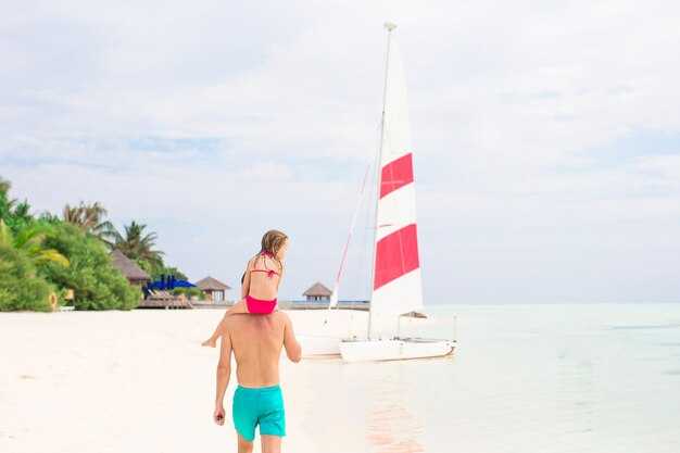
Recommendation: Start with a two-night stay in a beachfront hotel on Simpson Bay and set sail the next morning toward Grand Case to ease into trade winds and currents.
Based in Philipsburg, rent one of the catamarans anchored near Simpson Bay or join a crew aboard a locally operated charter, then cruise to the calm coves around Little Bay for a restful first night. Plan efficient hops of about 12–18 nautical miles each day, with shorter legs on lighter wind days to keep the crew ready and eager for the next stretch along the southern coast.
On day two, cruise to Orient Bay, then follow a path that hugs the coastline where rugged hills meet crystal water. Look for dolphins riding the bow wake, a sign of healthy habitat, and step ashore for a stroll through the streets of Grand Case–where fresh seafood markets and glamorous boutiques give you a taste of local life.
On land, arrange hikes including routes to viewpoints above Marigot and the interior trails that wind through the habitat of seabirds and tropical flora. Although some sections can be difficult after rain, these detours break the routine and keep the rhythm restful, especially after a day on a catamaran.
When you dock for the night, consider a quick stop at a manor-style villa or boutique hotel for a spa break, then chase unforgettable sunsets along the beach. The loistelias evenings on shore, paired with incredible snorkeling moments just offshore, make the itinerary feel based in real Caribbean charm.
whats included in this plan covers route options, recommended harbors, provisioning tips (fresh fruit, water, reef-safe sunscreen), and a packing list that keeps the crew ready for trade winds and occasional showers. Born travelers will appreciate the flexibility to rearrange days around wind, currents, and the dolphins’ playful habitat, so you can enjoy all three skies–sun, sea, and stars–without rushing.
Anse de Colombier to Philipsburg Route Overview
Check-in at your charter base, confirm weather, and trim sails for a southeastern leg along the leewards. Starting from Anse de Colombier, located on the leewards coast, set a friendly pace, keep the bow toward Philipsburg, and favor the lee to dampen seasick-chop. This route keeps legs short and enjoyable, with ample time for snorkelling and side trips.
The distance runs about 12–16 nautical miles, with a typical crossing of 2.5–4 hours under light to moderate trades. Steps to follow: 1) check-in, 2) raise sails, 3) head southeastern along the leewards, 4) monitor wind shifts, 5) adjust course to Philipsburg, and 6) anchor or dock in a public mooring near Front Street. The route traces reefs and shallow bays where you can wade for a quick refresh if needed.
Snorkelling opportunities appear near shallow reefs and around lee-side coves you can reach after a short sail. Drop anchor for 20–30 minutes at a protected spot, don your mask, and enjoy bright tropical fish. Keep an eye on boats approaching the anchorage and respect local regulations.
As you approach Philipsburg, ease into a public dock or anchored mooring near Front Street, which lines a bustling waterfront with shops and eateries. Philipsburg offers ample provisioning options and friendly service, making the stop rewarding. Aside from sailing, you can stroll the street, sample local bites, and plan a next leg with confidence.
Optimal Weather Window: Wind, Seas, and Seasonal Patterns
Choose a 7- to 10-day week in late February through early April to lock in the most reliable conditions: northeast trades around 18–25 knots and seas typically 2–4 ft in lee waters, with occasional 4–6 ft swells along windward routes.
According to latest forecast data for maarten, this window remains favorable, with pinel Island offering calmer micro-patterns and panoramic coastlines that invite relaxed cruising between favorite stops. The route features village charm and a rich selection of places to explore, all within easy reach of sheltered harbors.
Wind direction tends to stay northeast through spring, and orient your route toward protected bays and short hops between places. Average wind speeds run 18–23 knots, with gusts into the mid-20s to high-20s on gusty afternoons. Tropical conditions bring sunny mornings and seas that range from 2–4 ft in sheltered lanes to 4–6 ft along exposed channels, which you can handle with a stable boat and careful planning.
The seasonal pattern is straightforward: December through April provides the most predictable weather for cruising maarten and the surrounding isles. May to November brings higher risk of frontal systems and tropical showers, increasing cancellation risk and making flexible itineraries important.
For a week that features pinel, Grand Case, Orient Bay, and Philipsburg, the loop offers beautiful, panoramic views and a colorful sense of island charm. The path includes savannah coastline segments and a few village stops with delectable dining that’s a favorite for many sailors. Having a plan with multiple anchorages reduces stress if winds rise or seas swell unexpectedly.
Having a flexible schedule helps. If a leg shifts due to weather, shift to a closer harbor and enjoy an extra day at pinel or in a tucked-away cove, with turtle sightings along the beaches. This approach keeps the week enjoyable and minimizes wasted time.
Booking tip: check cancellation policies and fees. Look for options with flexible cancellation terms, typically with lower fees when canceled well in advance and modest reductions if weather forces changes. Confirm terms in writing to avoid surprises during peak season.
Looking ahead, the latest conditions favor a 7- to 10-day week that aligns with northeast winds, tropical days, and manageable seas, letting you look forward to beautiful sailing in maarten and the broader Caribbean, into a week of relaxed cruising and memorable moments.
Navigation Prep: Charts, Plotting, and Safety Gear
Begin with a dual-charting kit: current paper charts and a capable handheld plotter. Ensure coverage for the Saint Martin area and nearby islands, including safe depths, wrecks, and preferred anchorages. If you sail busy harbors or seek untouched coves, set a clear route with one backup and confirm your position every 15 minutes while underway.
Plot waypoints for safe depths, anchor zones, and hazards such as reefs and shoals. Keep a 0.5–1 nm buffer when approaching sandy coves and along the coastline; mark exits toward protected bays or quiet anchors. Use common-sense limits for night entries and maintain a contingency plan in shifting seas.
Safety gear: VHF with DSC, AIS, EPIRB, life jackets for all, a throw line, a first-aid kit, a fire extinguisher, and a waterproof bag for electronics. Test all devices before departure and keep a spare set of fuses, watches, and a whistle at hand. Maintain a simple equipment checklist and review it with your crew before each leg.
Docking and marina planning: verify current mooring options at major ports and prioritize marinas with security, power, water, and reliable access. For coastal visits, bring a compact headlamp and a color map for walking routes, and note access rules for reefs, protected areas, and popular dive spots. If a harbor fills up, switch to a nearby marina with better protection and calmer moorings.
Keep a post-run log of winds, currents, and the performance of each leg. Build a small range of go-to routes to handle sudden squalls, and reserve time for trips to quiet coves when possible. Maintain a clear, lean plan so the crew can adjust quickly as conditions shift.
Anchorages and Mooring Options Between Anse de Colombier and Philipsburg
Base in Simpson Bay Lagoon for effortless access to four locations along the coast, then reach Philipsburg quickly for immigration and restocking. This setup keeps your cruising simple, with relaxed evenings, excellent stress-free navigation, and a range of waterfront dining options within easy reach.
Between Anse de Colombier and Philipsburg, four locations stand out as reliable anchors or mooring bases: Anse de Colombier, Grand Case Bay, Orient Bay/Pinel Island, and Simpson Bay Lagoon. Each offers a distinct coastline feel, easy town access, and ways to tailor your days to favorites like casual eating, beach strolls, and fantastic snorkeling experiences.
Anchor or drop a mooring at Anse de Colombier first: the cove protects from trades blowing from the northwest and presents clear water and good holding in sand and weed bottom. Bring a modest scope and keep well clear of the rocky headlands. Morning arrivals let you beat cruise-ship crowds and set a restful pace for your next leg along the coast.
Grand Case Bay provides a waterfront vibe with a short hill climb to the town. Moorings are available through local operators, or you can anchor to a sheltered lee in the southern part of the bay. After arriving, stroll along the street to the lively waterfront, pick up provisions, and dine on Tropicana’s seafood and creole flavors–great as a base for four days of coastal exploring.
Orient Bay and Pinel Island create a relaxed, casual stretch where you could anchor near the western edge of Orient Bay or take one of the shallow moorings around Pinel Island. The coastline stays shallow enough for comfortable dinghy hops to the beaches, and the week’s experiences often include snorkeling, beachside eating, and a visit to Anguilla across the channel for a quick day trip if you’re sure about border rules.
Simpson Bay Lagoon remains the most versatile base for accessing Philipsburg and the ports along this route. The lagoon hosts a robust mooring field with simple check-in at nearby bases or harbors. It’s ideal for a restful night with easy shore access to towns, groceries, and immigration clearance when you arrive in Philipsburg. The area includes several waterfront options, casual dining, and easy water-taxi connections to the airport area and nearby towns.
| Sijainti | Protection & Depth | Mooring Options | Access to Towns & Services | Huomautukset |
|---|---|---|---|---|
| Anse de Colombier | Sheltered pocket; depths vary with seabed near 8–20 m offshore; avoid rocky headlands. | Anchoring only; no formal moorings commonly available. | Short dinghy ride to Colombier Beach and nearby trails; limited onshore amenities. | Great snorkel nearshore; keep clear of the outer reef line; perfect for a quiet start. |
| Grand Case Bay | Protected lee from northerly winds; shallower in the inner bay, deeper toward the channel. | Local operator moorings available; some anchorage in the southern approaches. | Walkable waterfront street with shops and restaurants; short climb to the hill for views. | Favorites include Tropicana for seafood; good for a night before continuing west. |
| Orient Bay / Pinel Island area | Avoinna pasaatituulille; parhaimmillaan heikompien pasaatien aikana; matalat rannikkoalueet lähellä Pinelin saarta. | Kiinnityspoijuja Pinel-saaren ympärillä; ankkuripaikka ulommassa lahdessa suuremmille aluksille. | Pääsy rannoille jollalla; Orient Bayn mukavuudet rannalla; helpot päiväretket lähisaarille. | Rento ja rentoutunut tunnelma; ihanteellinen rantakävelyihin ja rentoihin aterioihin; näkymät Anguillalle veden yli. |
| Simpson Bay Lagoon | Erittäin hyvin suojattu; leveä vesiväylä; syvyys sopiva useimmille matkapurjeveneille. | Lukuisia yksityisiä venepaikkoja; useat venesatamat tarjoavat palveluita ja vesitaksiyhteyden. | Lähellä Philipsburgia, ruokakauppoja ja maahanmuuttovirastoa – nopea saapuminen ja tullaus; useita rantaruokailumahdollisuuksia. | Rauhallisia öitä, helppo pääsy rannalle ja vankka tukikohta ympäröivien kaupunkien ja satamien tutkimiseen. |
Saapumisia suunnitellessa pyri saapumaan myöhään iltapäivällä vähentääksesi ruuhkia ja varmista aina suunnitelma maahanmuuttotarkastuksia varten Philipsburgissa tarvittaessa. Nämä neljä yllä olevaa paikkaa tarjoavat erilaisia risteilykokemuksia Anse de Colombierin lähellä olevista hiljaisista rannoista Grand Casen ja Philipsburgin vilkkaisiin ranta-alueisiin. Jokainen niistä on vankka tukikohta Karibian-lukuun, jossa yhdistyvät purjehduspäivät maukkaaseen syömiseen, näkymiin kukkuloille ja vaivattomiin siirtymiin kaupunkien välillä rannikolla.
Proviantti, vesi ja polttoaine: mistä varastoida ennen ylitystä
Täydennä varastot Karibian itäisissä solmukohdissa ennen ylitystä: täpötäydet satamat luotettavine varusteliikkeineen varmistavat hyvät varastot. Vieraile suurten supermarkettien sisäkäytävillä ja satamamyyntikojujen luona tankataksesi vesikanistereita, säilykkeitä, riisiä, öljyä ja monenlaisia herkullisia, säilyviä tuotteita. Soita etukäteen varmistaaksesi varastot ja aukioloajat, erityisesti ruuhka-aikoina, jotta yrityksesi täydentää varastoja eivät pääty viivästyksiin.
Veden suunnittelu alkaa vankasta tavoitteesta: varaa 60–80 litraa henkilöä kohden 4–5 päivän ylitykseen, jos sinulla ei ole suolanpoistovaihtoehtoa, sekä 25–40 litran varasto. Säilytä vesi suojatuissa, hyvin ilmastoiduissa lokeroissa, jotta se pysyy viileänä ja suojassa auringolta. Käytä 20 litran jerrykannuja helpon käsittelyn takaamiseksi ja täytä päätankit alussa; käsittele kaikki juomakelvottomat lisäykset ja merkitse säiliöt sekaannusten välttämiseksi. Varaudu muutamiin vierailuihin rantojen markkinoilla (usein täynnä olevissa, auringonottoon sopivissa satamissa) ja opi, mistä parhaan makuinen vesijohtovesi tulee kussakin telakointialueessa.
Propaanipolttoaine vaatii huolellista suunnittelua: kuljeta kaksi 9 kg:n (20 lb) pulloa, varapullo turvatyynynä. Säilytä pulloja ilmastoidussa, suojatussa tilassa etäällä kuumuudesta ja kaasuista, ja pidä mukana vuototunnistin ja varasäädin. Täytä pulloja venesatamien kaasupisteissä ruuhkaisissa lahdissa ja soita etukäteen varataksesi pullonvaihdon sesonkiaikana. Tämä polttoainemuoto pitää keittiön ruoanlaiton yksinkertaisena ja luotettavana pitkillä matkoilla, erityisesti kun haluat valmistaa herkullisia lämpimiä aterioita lintujen tarkkailun ja lempeän auringonoton jälkeen.
Valitse varastoihin sellaisia ruokia, jotka säilyvät pitkään: säilykekalaa, papuja, linssejä, pastaa, riisiä, tomaattituotteita ja kestäviä vihanneksia. Lisää yrttejä, oliiviöljyä ja mausteita, jotka kohottavat aterioita ilman, että ne kasvattavat niiden kokoa. Kun teet ostoksia, testaa muutamia makuja ja makumaailmoja välttääksesi tylsiä aterioita; satunnainen maukas välipala voi tehdä matkasta levollisen. Etsi satamien läheltä toreja, jotka tarjoavat tuoreita hedelmiä paikallisilta maatiloilta – herkullisia vaihtoehtoja ovat usein trooppiset mehut ja saarella kasvatetut välipalat, jotka kohottavat mielialaa mäkisten vaellusten tai rantakävelyiden jälkeen.
Polttoaineen suunnittelu kattaa myös lisätarpeet: ota mukaan riittävästi dieseliä moottorille ja pieni määrä ylimääräistä polttoainetta apujärjestelmiä varten, tarkista ja puhdista säiliö säännöllisesti. Merkitse kaikki polttoainesäiliöt selkeästi ja säilytä niitä etäällä vesipisteistä ja asuintiloista. Jos sinulla ei ole polttoaineen siirtosuunnitelmaa, keskustele satamamestarin kanssa käyntisi aikana parhaista vaihtopisteistä; tämä minimoi riskit ja auttaa sinua pysymään aikataulussa vilkkaissa satamissa.
Roskien käsittely ja rantautumistehtävät ovat myös tärkeitä. Pakkaa tukevia pusseja ja lajittele jätteet rannalla niille varatuissa paikoissa, jotta vältytään sotkulta kannella. Pidä maalaamattomat köydet puhtaina ja hävitä pakkaukset asianmukaisiin säiliöihin satamatiloissa. Siisti vene parantaa turvallisuutta ja jokaisen aterian makua sekä vähentää kitkaa miehistön ja paikallisten miehistöjen kanssa, jotka partioivat hiekkarannoilla ja laitureilla. Olemalla kurinalainen roskien suhteen suojelet koskemattomia, suojeltuja vesiä, joilla purjehdit Amerikan ja Britannian historiallisten satamien välillä, ja sinulla on aikaa nauttia upeista näkymistä ja muutamista hiljaisista hetkistä rentouttaviin iltapuheluihin miehistön kanssa.
Lopuksi, käytä yksinkertaista lähtöä edeltävää tarkistuslistaa oppiaksesi kunkin sataman ainutlaatuiset piirteet: laiturityypit, paikalliset aukioloajat ja saatavilla olevat tuotteet. Tämä käytännöllinen lähestymistapa estää sinua ryntäämästä ruuhkaisten markkinoiden läpi ja auttaa sinua suunnittelemaan rauhallisen ja täydellisen ylityksen. Nyt luotu rutiini palvelee sinua hyvin tulevien ylitysten aikana, ja huomaat nopeasti parhaat paikat varastojen täydentämiseen, hiekkaisilta rannoilta piikikkäisiin pensaikkoihin rantaviivaa pitkin – jokainen pysähdyspaikka vahvistaa proviantin hankintatottumuksia, jotka maksavat takaisin maussa, luotettavuudessa ja mielenrauhassa.
Päivittäinen tilannekatsaus: Aikataulutus, etäisyydet ja pysähdyspaikkavaihtoehdot
Suunnittele 4 päivän reitti: purjehdi Martinsista kohti Grand Casea, sitten Basseterrea, sitten Nevistä ja takaisin Hollannin puolelle rentouttavaa loppua varten. Pidä jokainen osuus noin 18–30 merimailin mittaisena, jotta pysyt rentona ja sinulla on runsaasti mahdollisuuksia nähtävyyksien katseluun ja ruokailuun matkan varrella.
-
Päivä 1 – Ajoitus, etäisyys, välilasku
Lähde martineista klo 08:00. Matka 15–20 nm Grand Caseen, tyypillisissä pasaatituulissa kestää 3–4 tuntia. Saapuminen Grand Casen suojaisaan satamaan tarjoaa rauhaa ja helpon pääsyn rannalle nopealle kävelylle ja ikkunaluukut-edessä-valokuville rantakadulla. Alue on edelleen suosittu, mutta voit välttää väkijoukkoja tutustumalla läheisiin poukamiin. Yöpyminen Grand Casessa tarjoaa upean auringonlaskun ja aitoa kreolilaista ruokaa, ja lukuisia vaihtoehtoja on helposti saatavilla. Jos laituri on täynnä, ankkuroi hieman rannikosta ja käytä kumivenettä maihin laskeutumiseen; tämä pitää rennon tunnelman ennallaan perheelle tai ryhmälle, joka vuokraa veneen missä tahansa rannikolla.
-
Päivä 2 – Ajoitus, etäisyys, välipysähdys
Lähde purjehtimaan noin klo 07:30 Basseterreen, St Kittsiin. Matka 28–32 nm; odota 5–6 tunnin purjehdusta tasaisilla pasaatituulilla. Basseterren sataman sisäänkäynti on suoraviivainen; voit kiinnittyä sisälaituriin tai asettua suojattuun paikkaan. Kaupunki on täynnä markkinapäivinä, mutta se on edelleen suosittu historiansa ja modernien mukavuuksiensa ansiosta. Tee lyhyt retki Charles Fortiin nopeaa nähtävyyksien katselua varten ja vaeltele sitten lähellä olevien kartanotyylisten tilojen ja historiallisen rantakadun läpi. Ruokapaikkoja on lukuisia, rentoista kojuista hienompiin ravintoloihin. Perheille käveltävät kadut ja rauhalliset illat auttavat kaikkia pysymään rentoina ja yhteydessä lahdenäkymään.
-
Päivä 3 – Ajoitus, etäisyys, pysähdys
Lähde Basseterresta klo 08:00 lyhyelle matkalle Charlestowniin, Nevisiin. Matka 10–12 mpk; purjehdusaika 2–3 tuntia. Ankkuroi tai kiinnity lähelle Charlestownia, joka on suojaisa satama hyvien rantautumismahdollisuuksien päässä. Sieltä voit vierailla Montpelier Manorissa viettäen puoli päivää historian ja vuoristomaiseman rauhaisissa maisemissa. Saaren tunnelma syntyy luukuista ja valkoiseksi kalkituista mökeistä kujien varrella, mikä luo rennon tunnelman ja sopii täydellisesti leppoisiin päiviin perheen kanssa. Ruokailuvaihtoehtoja on lukuisia, mukaan lukien rantagrillit ja paikalliset majatalot, mikä tekee tästä miellyttävän pysähdyspaikan rennolle tahdille ja unohtumattoman vastakohdan vilkkaammille satamille.
-
Päivä 4 – Ajoitus, matka, pysähdys
Suuntaa takaisin kohti Martinsia ja tee lopuksi pysähdys Marigot’ssa tai piipahda Simpson Bayssä. Matka 22–28 merimailia; 4–5 tuntia. Marigot tarjoaa vaatimattoman sisäänkäynnin vilkkaaseen markkinatunnelmaan ja maisemien katseluun, kun taas Simpson Bay tarjoaa kätevät telakointimahdollisuudet ja rennon lopetuksen matkalle. Tämä viimeinen etappi on tilaisuutesi vuokrata kumivene nopeaa rantaan nousua varten, täydentää välipalavarastoja ja nauttia rennosta, perheystävällisestä päätöksestä. Päivän tahti pysyy kiireettömänä, ja koko reitti jättää sinulle unohtumattoman seesteisyyden tunteen ja upeimmat näkymät matkan päättämiseksi missä tahansa rannikolla.