

 Marine Weather Patterns and Forecasting – A Deeper Dive for Sailors">

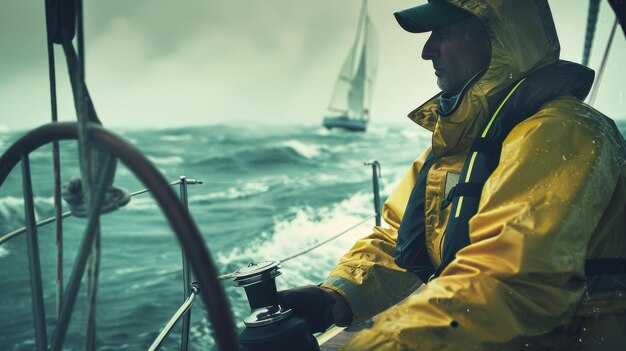
Always review the morning forecasts for your route and adjust your sail plan accordingly. This quick check helps you know when calms may linger and when brisk winds will build speeds along the course, guiding your navigation decisions and the vessel’s readiness.
Weather moves in formations shaped by pressure systems and thermal contrast; example, a passing trough can sharpen winds from the shore and alter seas. These cues often require you to time sail changes, adjust heading, and keep the vessel on track while you watch the seas for any sudden shifts, guided by nature’s signals and the sailors’ experience.
To forecast with confidence, use a small, repeatable process: check two reliable models, compare surface observations, and know your vessel’s performance. Specifically track wind shifts, gusts, and sea turning, then adjust sails and speeds to suit cruising legs. Record how these changes affect the vessel’s trim and comfort.
During early morning windows, keep an eye on gust fronts approaching from the land, and watch for calms that can reduce boat speeds. Create a simple plan for the next two legs, mapping departure times, tacks, and sail adjustments so the crew stays coordinated.
Keep data current and share key updates with the crew; forecasts become practical when you translate them into concrete actions for every leg, from harbor to open sea. This approach supports calmer handling, safer navigation, and a smoother cruising experience.
Reading Zone Marine Forecasts: Wind, Gusts, and Speed Thresholds
Read the zone forecast and set your sail plan from the numbers: sustained wind, gusts, and their changing trend. For offshore passages on these voyages, reef early and keep a safety margin when gusts approach 30 knots. Use predictwind data and satellite updates to verify the forecast and shorten response time.
These forecasts provide direction, wind speeds, gusts, and water heights. Pressure trends and changing heights signal potential storms; a rapid drop in pressure with a shifting wind pattern often precedes gusty periods. In such windows, shorter legs, smaller sails, and a cautious course keep the crew safe and the boat balanced.
Interpreting wind speeds, gusts, and thresholds
- Sustained wind versus gusts: gusts typically add 20-40% to the sustained value; plan for gusts to reach the upper threshold.
- Gust thresholds: watch for gusts above 25 knots in light to moderate conditions; reef or adjust sails when gusts approach 30 knots offshore.
- Wave heights: 15–20 knots often produce 1–2 m waves; 25–30 knots can push 3–4 m, with larger sets during squalls.
- Symbols on the forecast: larger or bolder symbols indicate higher winds; these symbols mean less guesswork and quicker decisions.
- Direction: a steady wind path confirms risk of a front; a sudden shift in direction often precedes gusty bursts.
- Pressure trend: falling pressure is a warning sign for increasing winds and rougher water; rising pressure suggests improving conditions.
- Associated activity: combine wind, gusts, and wave height to judge boat handling needs and crew workload.
- robert’s tip: keep a simple log of wind shifts and sail trim to refine readings for these zones and future passages.
- Fish and wildlife: wind shifts and water roughness influence fishing spots and shore activity; plan lookouts accordingly.
- deer: coastal sightings remind you to remain vigilant near estuary approaches and crowded ramps during transitions between zones.
Practical steps for these voyages
- Before departure, set thresholds for each leg: reef when gusts exceed 28–30 knots, and choose smaller sails or revised course for offshore legs.
- During the leg, reef promptly if gusts break the set threshold; adjust heading to keep the breeze from the beam when possible to reduce heel and load.
- Use satellite data alongside the provided zone forecast to confirm stability; cross-check with predictwind for near-real-time updates.
- Monitor pressure trends: a 6–8 hPa drop in 6 hours usually signals a strengthening wind window; plan reefing steps in advance.
- Watch wave heights relative to wind: if water shows faster build toward 3–4 m, shorten the leg or seek sheltered water to reset the plan.
- Keep a simple log of wind direction changes and sail responses; robert’s approach helps you build a faster reaction routine for these voyages.
- In coastal zones, factor wildlife and shore activity into your lookout routine; use forecast signals to time transitions when the shoreline activity is calmer.
Interpreting Sea State: Waves, Swell, and Periods for Planning
Check the swell period and height now to set a safety-first cruising plan, then review pressure trends, storm systems, and the tide for your route.
Reading the Numbers: Waves, Swell, and Periods
Waves are generated locally by winds; swells originate from distant storm systems and can arrive beyond the immediate fetch, delivering a smoother roll. The period, in seconds, shows how quickly crests pass a fixed point and helps you estimate peak forces on the hull and rig. Generally, short periods (under 8 seconds) signal wind waves near shore, while longer periods (over 12 seconds) indicate long-period swells that persist beyond coastal shelves. Early forecast data from operators provide a range; then you compare this with sea-surface temperatures and wind direction to judge risk. robert, a seasoned cruiser, notes that reading the period helps you plan safe transit near river mouths and the shore. Provided you see sudden shifts in pressure or wind, expect sudden changes in wave height and plan safety margins. For coastal regions, animal behavior such as seabird patterns can hint at shifting conditions. Near the shore, lower water and tide can amplify energy. Always cross-check several sources and include a contingency plan for possible changes.
Planning in Practice for Sailors
To translate numbers into actions: identify the swell direction relative to your course, choose routes that keep the helm in manageable trim, and avoid attempting heavy maneuvers in shallow water near the shore or in tide-dominated channels. Always have a safety margin and a contingency plan, especially for cruising with multiple crew. Several options exist: delay departure for an early lull, reroute offshore, or seek sheltered harbors provided weather allows. In practice, rely on multiple forecast sources, compare models, and factor in temperatures and river outflows that modify wave energy. If the data comes from buoys and satellites, use it to guide decisions; didnt rely on a single source. This approach keeps sailors safe and helps you maintain course efficiency and safety.
Currents, Tides, and Coastal Impacts in Zone Forecasts
Plan passages to ride slack water windows; check the zone forecast for currents, tides, and coastal impacts at least 6 hours ahead to decide safe routes for inlets and shoals and avoid strong flows in short legs.
Current origins lie in tides, wind-driven flow, and offshore pressure systems. Inlets and coastlines create strong shear, and a front moving alongside the coast can cause rapid shifts in speed and direction within hours. Keep charts handy and compare with buoy data to confirm the forecasted trend.
Since the forecast depends on tide phase, fronts, and storm activity, the exact current speed varies; this matter informs navigation and helps you decide when to sail and how to adjust course. This is a critical input for risk assessment; an aspect of forecast use is recognizing how tides and fronts interact to raise or lower current strength and wave energy, yielding higher risk near headlands.
Precautions include timing passages for slack water, maintaining a wide margin from shoals, and having a contingency plan for gear damage or prop strikes. In narrow channels, do not push above 3–4 knots when a strong ebb is forecast; if showers and clouds approach, delay the move or seek shelter until winds ease.
Satellite data, radar, and surface observations provide information that helps you learn the timing of shifts and assess potential storm impacts. When a storm approaches, expect higher seas and more dynamic currents; use this to decide whether to sail now or hold until winds ease and the water stabilizes, sailing safely. Clouds, showers, and satellite cues together sharpen your navigation decisions and help protect gear from damage.
Weather Transitions: Fronts, Squalls, and Thunderstorm Risks
Identify the front ahead and set a plan now: note distance to the leading edge and track its progression across miles and routes. This knowledge gives mariners a clear basis for decisions and keeps you ready during the passage of a front. They play a key role in how you space the boat and coordinate with the crew; consider getting observations from more than one source to improve accuracy.
When a front crosses, expect wind shifts and rising seas: speeds change from 12-18 knots to 25-40 knots within 30-60 minutes, and wave heights can rise from 1.5-3 meters to 3-5 meters depending on fetch. Heavily loaded vessels should adjust sails ja reduce speed early. Track the front using cross-referencing radar, barometer, and satellite data to confirm its passage and timing, and use distance cues like cloud trends to maintain accuracy where possible.
Squalls can accompany the front or ride along its passage, delivering sudden gusts and brief downpours that reduce visibility to under 2 miles. Gusts commonly reach 25-50 knots for 5- to 15-minute bursts; seas respond quickly and wind swings can approach 20-40 degrees. If youre navigating, varotoimet sisältää reefisailsien käyttöönoton, varusteiden kiinnityksen ja valmiiden reittien hankkimisen turvallisempaan kynttaan tai moottorin nopeuteen siirtymistä varten. Pidä miehistö valppaana heidän tarkkaillessaan aukkoja linjassa, joissa ukkoset solut saattavat ylittää reittisi.
Urat ovat tuoden lisäriskejä: salamoita, laskeumia ja mikropurkauksia. Pysy poissa pahimmista ytimestä 10–20 mailin puskurilla, äläkä ole linjassa myrskyn kanssa, jossa tuulet voivat voimistua. Solut voivat tuottaa jatkuvia tuulia 40–60 solmua ja kovemmat puuskat; seuraa myrskyä tutkan avulla ja ristiintarkista tietoja pysyäksesi accuracy ja valitse turvallisempi reitti sivulle tai taakse linjasta. Konvektiivisen sään keho on dynaaminen, joten sinun tulee odottaa nopeita muutoksia ja pitää koko tiimi tietoisena.
Näiden siirtymien aikana jaa tietoa miehistön kanssa, jotta pysytte yhdessä ja turvamarginaalit säilyvät. Tämä lähestymistapa antaa merenkävijöille käytännön näkemyksiä, jotka ylittävät reitit ja aikavyöhykkeet. Hyvin harjoitellulla suunnitelmalla olet paremmin valmistautunut pitämään etäisyyttä aktiivisimmista soluista, seuraamaan niiden kulkua ja säätämään reittiäsi sen mukaisesti. Muista: tarkkuus tuulen arvioinnissa, etäisyys soluun ja konvektion todennäköisyys parantaa turvallisuutta ja pitää sinut liikkeessä kohti seuraavaa väyläpistettä luottavaisin mielin.
Ennusteesta matkaan: Käytännönnöllinen reittisuunnittelu ja riskien tarkistukset
Tarkista viimeisin barometrinen kehitys ja tuuliennuste reitillesi, ja luo sitten turvallinen reitti, joka pitää sinut riutta-alueen ulkopuolella ja kaukana rannasta.
Tämä suunnitelma edellyttää mallien vertailua ja tuulten ja merien järjestelmien huomioon ottamista, mukaan lukien näiden tuulten alkuperä. Käytä useita ennusteita ja tarkista luotettavasta paikallisesta tiedonlähteestä.
Määrittele väyläpisteet tarkalla pääsyllä turvasatamiin tai rantaan; huomioi aika marginaalit ristikoille ja käännöksille, ja merkitse kääntöpisteet karttaan ennen lähtöäsi.
Ennakoi vaarat: trooppiset myrskyt, suuri aalto, riutta ja eläinten liikkeet lähellä rantaa. Tunnista mahdollisia poistumisteitä, jos olosuhteet huononevat.
Muutoksille asetettaessa käynnistimiä ei saisi olla arvaamista. Tarkista kunkin osuuden tiedot, mukaan lukien tuulen suunta, nopeus, meriolosuhteet ja barometrisen paineen muutos minuuttien aikana.
Hanki tietoa vuorovesi- ja virtauksista; tarkastele vuorovesi-ikkunoita aamunkoitolla tai yöllä; suunnittele lähtö lähellä rantaa olevalta slack-vedeltä maksimoidaksesi ohjattavuuden ja turvallisuuden.
Annetut turvamarginaalit: pysy vähintään 2 meripeninkulmaa koralliriuttojen reunoista ja 1,5 meripeninkulmaa matalikkojen läheltä, pidä selkeä väli liikenteestä ja säilytä mukava puskuri rannasta ja kannen turvallisuudesta.
Laadi rinnakkainen suunnitelma: jos ennustetut olosuhteet huononevat, siirry rinnakkaiseen reittiin kohti seuraavaa suojaisaa rantaa tai suojaa, ja dokumentoi vaihtoehtoinen kurssi lokikirjaasi.
Tuntemus lähestymistavasta, yhdistettynä käytännönnolliseen ennustelukioon, lisää itseluottamusta. Seuraa ilmanpaineen muutoksia, trooppisia varoituksia ja tuulen suuntapäivityksiä, jotta voit säätää lennossa.
Yötoiminnot vaativat kurinalaista vahtivuoroa: alenna nopeutta, suorita suuntalukemat, ennakoi häikäisyä, käytä asianmukaisia valoja ja pysy valppaana aaltojen ja virtausten suhteen.