

 Boating Navigation – Essential Tips & Tools for Safe, Confident Cruising">

Aloita jokainen matka lähtövalmistelulistalla.päivitä kaaviot, tarkista tunnetut vaaralliset tilanteet, aseta välimerkit ja varmista sää- ja vuorovedotiedot. Valmistellessasi varmista, että miehistön aikaa käytetään yhteen, jäsenneltyyn rutiiniin. Tämä vähentää viime hetken yllätyksiä ja auttaa saamaan päivityksiä 10 minuutin sisällä, jos olosuhteet muuttuvat.
Perinteinen taidot yhdistyvät moderniin systems. Käytä kompassitarkistuksia yhdessä sähköisten karttojen ja AIS:n kanssa show Tilanne veden pinnan yläpuolella ja alapuolella, avustaa vilkkaita kanavia kulkevaa navigointia. Pidä jatkuva turvallisuuskatselmus: tarkista sammutuslaitteet, pelastusliivit ja signaalivälineet.
Huomioita satamamenettelyistä: Pidä konservatiivinen nopeus ruuhkaisissa kanavissa (6–8 solmua), noudata vakiintuneita liikennemalleja ja keeping selvästi vilkkaiden väylien ulkopuolella. Tee nopea 2 minuutin tarkistus jokaisen satamasisäänkäynnin jälkeen ja jatka suunnittelua uudella datalla.
Matkojen aikana lähellä green markers, tarkista suuntia tunnettujen maamerkkien avulla, aika kuluu, ja mittaa accuracy vastoin vuorovesi taulukoita. Baijerin jokireiteillä, sopeudu kapeisiin kanaviin ja voimakkaampaan virtaan.
Jaa suunnitteludataa miehistön kanssa, tallenna notes poikkeamista ja päivitä loki jokaisen vuoron jälkeen. Tapauksessa, jos äkillinen situation, laukaise hälytys, vaihda varajärjestelmään systems, ja pidä time ajatuksissa.
Veneilynavigointi: Kompassinavigointi – Käytännön vinkkejä ja työkaluja turvalliseen ja varmavaraiseen purjehdukseen
RecommendationAsenna tukeva magneettikompassi selkeällä kehyksellä, aseta se suojattuun, häiriöttömään paikkaan ja pidä offline-varmuuskopio kompassista aluksella. Purjehtiessa tee ristitarkistus kompassin suunnan kanssa maamerkkien ja kartan avulla, jolloin saat luotettavan totuuden lähteen jopa silloin, kun elektroniikka pettää.
Miten lukee laakereitaMääritä suunta kohdistamalla näkölinja kiinteään kohteeseen ja lukemalla suunnattu kulma kehässä; sen jälkeen säädä voimassa olevaa muuntumaa ja tarvittaessa poikkeamaa oman veneen järjestelmästä. Merkitse astetta, minuuttia ja sekuntia lyhenteinä kenttäsivuille sekä pidä muistiinpano esimerkiksi N, E, S, W nopeaa tarkistusta varten. Tietyt toimenpiteet vähentävät virhettä tuulisissa olosuhteissa.
Käytä reitin varrella olevia maamerkkejä lasketun kurssin vahvistamiseen; ota myös huomioon, että nopeat tuulen muutokset tai puuskat voivat työntää alusta pois puhtaasta magneettikompassisuunnasta. Varmuuskopiona käytä rannikon kiinteitä paikkoja, jotka ovat näkyvissä satamista ja tunnettuja suunnittelualueen karttojen perusteella. Kytketyn kompassin ja itsenäisen tietolähteen yhdistelmä pitää sinut linjassa vaikka GPS pettäisi.
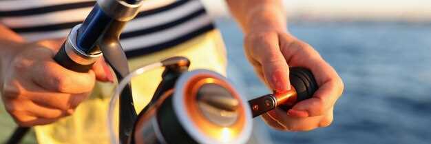
VarusteluetteloVarmista, että kompassi on varustettu ja asennettu asianmukaisesti, tarkista johdot tai kytkennät, jos se on osa suurempaa järjestelmää; pidä varalla toimiva akku, jotta instrumentti pysyy toiminnassa, kun päävirta on poissa. Asenna toinen laite nopeaksi varmuuskopioksi ja merkitse asennusalue ilmoituksella miehistövaihtojen varalta. Katso venesatamista ilmoituksia magneettisista häiriöistä satamaa lähellä olevien virtakaapeleiden lähellä; Bavaria tarjoaa paikallisia ohjeita viranomaisilta; käytä näitä yhtenä totuuden lähteenä.
Suunnittele ja harjoitteleKun suunnitelmia luodaan, merkitse alue ja mahdolliset paikat, joissa on magneettista häiriötä (lähellä virtakaapeleita, moottoreita tai kuormia). Taloudellisista syistä pidä mukana pieni laminointikortti, joka näyttää paikallisen magneettisen vaihtelun alueittain. Veneilijöiden tulisi vaihdella magneettisen suunnan ja todellisen kurssin välillä kartalla välttääkseen ajelehtimista. Seuraava tapa parantaa itseluottamusta, erityisesti yöllä tai sumussa.
HuomioPidä silmällä moottorikaapeleita ja sähköjohtoja häiriöiden estämiseksi; pidä kompassin ympäristö vapaana ferromagneettisista esineistä, vältä metallivaihteita ja pidä kannettavat laitteet poissa kompassista; pidä suuntaa vääristävä etäisyys jaloissa lähteen suhteen. Tulipalovaara polttoainejohtojen lähellä vaatii nopean reagoinnin ja poistamisen, jos tuuli aiheuttaa kipinän. Veneilijöiden tulisi käyttää yksimoottorista toimintaa, kun he luottavat magneettiseen suuntaukseen satamassa; jos havaitset poikkeaman, tarkista uudelleen kartalla ja säädä viranomaisten vaatimusten mukaisesti.
Offline-toiminta remains practical on long crossings; this aligns with ownership and the system approach, enhancing resilience when power or electronics fail. The technique can be tested in different area conditions; bavaria’s coast offers hills that alter line-of-sight to landmarks, so rely on those sights to verify bearings. Keep a single, economical kit that includes a spare battery, a laminated field card with abbreviations, and clear plans for switching between magnetic bearing and charted courses.
Magneettikompassin navigointi: Keskeiset käytännöt turvalliseen ja luottavaiseen purjehdusmatkaan
Aseta aina magneettikompassisuunta aiottuun kurssiin ennen lähtöä, sitten tarkista se toisella menetelmällä, kuten GPS:llä tai maamerkeillä. Tämä pitää sinut oikealla kurssilla vesiä pitkin, joita virrat ja tuulen suunnat hallitsevat, ja mahdollistaa luottavaisemman purjehduksen.
Regular learning ja following a structured class auttaa rakentamaan awareness of eroja kompassin lukemien ja todellisen suunnan välillä. Käytä offline practice to reinforce muscle memory: swing the compass, compare with chart data, and log observations in your ownership notes.
Pidä kädessä pidettävät ja kiinteät instrumentit sisällä servicetarkista halkeamat, vaihda kehyksen ympäröinti ja varmista että lataa on riittävä varmuuskopiointilaitteille. Kun matkat sisältävät fishing tai lähestymässä around shoals, use the bearing to steer a secure kaari ja tarkista säännöllisesti.
Veneilijöiden tulisi ymmärtää, että many tekijät vaikuttavat lukemaan: paikallinen vaihtelu, eroja kartan ja näytön välillä sekä metalliesineiden vaikutuksesta. Pidä aina data from multiple means ajatellen ja yhdessä kehittäen vahvan tavan pysyä oikealla kurssilla.
Käytännöllinen rutiini: tarkista suunta, tarkista sitten uudelleen käännöksen tai veden, virtausten tai tuulen muutoksen jälkeen; pidä kirjaa, tarkista. awareness data after each tripja include notes on how technology ja products performed offline and online.
Pre-Departure Compass Check: Declination, Deviation, and Swing
Set your magnetic compass to the latest declination from the updated chart or источник on deck, then lock the setting. Cross-check with the deviation table to ensure the numbers reflect current waterways, and log the change in a quick table aboard to support your plans and trips. Document the detail of the adjustment to aid crew work during pre-departure checks.
Compute the true heading by applying two corrections to the observed compass heading: deviation (D) from the vessel’s deviation table, and variation (V) from the chart. Use the equation TC = CH + D + V, with signs taken from the sources. Example: CH 090°, D = +2°, V = +5° yields TC 097°. When D or V are negative, adjust accordingly to keep your plotting on the intended type of course.
Perform a swing check while berthed: rotate the wheel through 360 degrees and compare the compass reading with a fixed reference bearing from landmarks or a charted line on the plotter. Note what you observe, expect swing to stay within roughly 0–6° on a typical hull; larger swing indicates residual magnetism or nearby damage. If you detect excess swing, pause, reassess deviation data, and rely on a quick, powered backup such as GPS overlay to confirm the route while you adapt.
If the hull or compass shows damage, or interference from gear is suspected, rely on a gyro compass or GPS-based track as a stand-in. When youre plotting trips through channels, a lake passage, or long waterway legs, keep a stand-on bearing in mind and enable a quick cross-check with the GPS plot to stay carefree and on plan.
Document the updated data in a dedicated table on deck, mark источник as the data source, and share the results with everyone aboard, including the charter crew. This detail keeps your plans aligned, reduces risk during long trips, and enables carefree travel between water channels.
Reading the Compass at the Helm: Navigating with Pitch, Roll, and Spray
Lock the helm and confirm a stable bearing by aligning a magnetic compass with sense4boat data, and use aids such as a gyro or fluxgate to cross-check readings; verify signal quality via hdop readouts, which is more accurate than a single instrument. If the numbers drift beyond ±3 degrees after a 15-second check, then re-center and re-check against the tide.
On deck, shifting seas produce spray that fogs the compass card. Keep your gaze through the binnacle, practicing calm helm corrections, and react quickly to small deviations; blasts from waves can push readings off, so strive to adjust before another span passes. This reduces collisions, a clear advantage in distress situations. Stay mindful of regulations.
Bilge pump readiness matters; ensure lines are clear and checks don’t interfere with cockpit instruments.
Learning updates from a network of owners, Bavaria sail owners, and suppliers of products keep you informed. Sense4boat readings, hdop trends, and numbers flux matter more than a single instrument. Informed care stays steady; you become more capable as conditions change through dives, tide, blasts, and gusts, and the approach can feel carefree yet precise. This significantly sharpens decision making.
| Condition | Action | Huomautukset |
|---|---|---|
| Pitch > 5° or roll > 6° | Return to bearing; recenter; cross-check hdop | Cross-check with sense4boat; then lock |
| Spray obscures readout | Recenter; adjust to keep readings aligned | Keep eyes on cards; monitor spots |
| Reading drifts on spots | Record numbers; compare with network updates | Become consistent; updates help |
Correct for Variation and Deviation in Real-Time Bearings
Always validate bearings in real time by cross-checking magnetic readings with GPS positions and known visual cues, including buoys and upstream references to confirm alignment with the intended course.
- Baseline setup: pull local variation from a current chart or offline apps, then set that value in your compass settings and the electronics display, creating a single reference used in quick checks.
- Continuous cross-check: maintain alignment between magnetic bearing and GPS-derived course; compare positions against marina charts and a few fixed marks; when a discrepancy is detected, adjust bearing values immediately and log changes with concise abbreviations.
- Crew responsibilities: assign a quick observer to watch visual cues and buoys; keep the crew informed, involve your electrician when hardware readouts drift, and ensure the log is updated with care.
- Interference and drift: be mindful of blasts from nearby equipment or power lines that can shift readings; recalibrate, verify compass alignment, and test against a known set of courses to restore accuracy.
- Offline resilience: if connectivity or apps go offline, rely on positions, visual cues, and a trusted set of tracks; maintain a small record of bearings, positions, and courses to speed real-time decisions.
- Maintenance discipline: keep electronics well maintained, replace batteries, and review settings regularly; theres a need to verify readings after any calibration, and the crew should review the log after every trip; involve your electrician for a hardware check.
- Reference tools: use marina charts, buoys, and equipment to confirm alignment; with many inputs, accuracy improves; always align your heading with a good visual reference and a backup from apps or GPS.
Cross-Check Bearings with Charts, GPS, and Visible Landmarks
Check bearings against three sources: charts, GPS, visible landmarks before every leg. In practice, run the three-source check to confirm your position within the area, then update as you move. This approach increases accuracy when approaching busy zones such as wakeboarding zones, and when dealing with depths that change with tides.
- Charts and abbreviations: Read the fundamental bearing shown on the chart. Use the chart source; verify scale, grid, declination, and abbreviations in the legend. Note depths in the area and record what you see in your log tables to reference later.
- GPS and sensors: Compare GPS bearing with chart bearing; check sensor status, time, and update rate. If readings diverge beyond a small margin, switch to dead reckoning and relying on landmarks until readings align. Set an alarm if drift persists beyond 2–3 minutes.
- Visible landmarks: Identify at least two fixed features on shore or buoys; take visual bearings to each, compare with chart positions, and verify your location every few minutes. This critical step helps when GPS is degraded or signal is limited.
- Handling discrepancies: If misalignment exceeds a preset threshold, execute a rapid cross-check using what you know about depths and the ship’s wake. Update course gradually to reestablish your path.
- Record keeping: Save information in a dedicated log; include time, location, measured bearings, and notes. Refer to books or class materials, and fill in tables with abbreviations you can glance quickly. This ensures everything is captured.
- Practical practicing: Before class or during drills, run this routine on a known journey route. Practicing increases tolerance to misalignment as you sail near zones and other craft. What you learn here becomes baseline behavior when sailing in unsettled conditions. This practice will increase your accuracy.
Maintaining the Compass: Cleaning, Storage, and Magnetization Prevention
Start with a clean, magnetically neutral base: wipe the compass face with a soft microfiber cloth, rinse with fresh water, and dry thoroughly. Use a mild soap if needed; avoid solvents. Keep the unit above the deck to minimize moisture ingress and prevent water marks on the glass. After cleaning, verify the north reference against a distant mark or marks on a chart, confirming accuracy before heading out on the journey.
Maintain proper storage: when not in use, place the compass in a dry, cool container away from ferrous hardware, high-current cables, and any electronic sensors that could induce stray fields. The goal is to keep the dial balanced; avoid exposure to ferrous metals that can magnetize the dial. Store with the face up to help back bearings and maintain readability.
Magnetization prevention: keep the instrument away from beidou antennas and other magnet sources around the cockpit; a single magnet can cause drift, producing multipath-like errors when plotting routes. If you notice drift, perform a simple calibration against a known north reference. This must be part of your awareness at all times.
Simple checks during plotting: use sense4boat to compare compass output with GPS sensors; taking updates from authorities when away from shore; stay aware of distances and routes to limit collisions. If sensors show a discrepancy, develop understanding that a great deal of external influence can upset readings and adjust accordingly.
Charter crews, especially in bavaria, must stay aware of a routine that keeps the compass reliable. Start each day by checking alignment, and stay prepared with a back-up bearing. The aim is a carefree journey with reliable bearings, while authorities oversee safety and distances to other vessels along busy routes.
Regular checks create awareness of multipath and external interference that sensors may reveal. Building understanding of how external factors affect readings helps you stay able to plot more accurately. A simple, repeatable routine–clean, store, magnetization precautions–keeps distances and routes accurate, making back-up bearings usable when conditions are rough. Stay mindful of authorities and be proactive in maintaining performance on the journey ahead.