

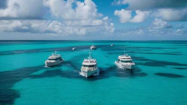
 Nassau to Eleuthera Yacht Charter Itinerary – A 5-Day Bahamas Sailing Route">
Reserva el chárter de Nasáu a Eleuthera con Harbour Island como parada del Día 1 para mantener las piernas por debajo de las 70 millas náuticas y maximizar las mañanas tranquilas. Esta opción te protege del oleaje del final de la tarde, te permite fondear cerca de Pink Sands Beach y le da a tu tripulación tiempo para un refugio kayak sesión a lo largo de calas justo al este del puerto. Allí, te instalarás en tu base de operaciones en Nassau, completarás la sesión informativa de seguridad y planificarás el primer tramo; considera un posible desvío hacia las ábacos si los vientos cambian favorablemente allí.
El día 2 cubre entre 20 y 28 millas náuticas hasta Spanish Wells o Governor's Harbour en North Eleuthera. El estado del mar por la mañana tiende a ser tranquilo, con una brisa constante del este que mantiene el barco cómodo a lo largo de la costa de sotavento. El abastecimiento es sencillo en Spanish Wells, y un corto paseo por la costa combina bien con una puesta de sol. kayak vuelta por los manglares. also, si el viento coopera, puede desviarse brevemente hacia johnston para una parada de esnórquel antes de continuar al siguiente puerto.
El día 3 te lleva a lo largo de la costa este de Eleuthera hacia Cabo Eleuthera y Rock Sound. El paisaje combina acantilados escarpados con aguas turquesas, y kayak a lo largo de caletas ofrece la oportunidad de ver aves marinas y rincones escondidos. Un atardecer plunge El sumidero Ocean Hole de Rock Sound es un momento culminante para cualquiera que disfrute de un chapuzón refrescante después de un día en el mar.
El día 4 continúa hacia la mitad sur de Eleuthera, con una parada en Tarpum Bay y una aproximación final a Governor's Harbour. Espere aguas tranquilas por la mañana, luego un suave impulso del sureste que permite una parada en la playa y hacer esnórquel. Para los navegantes que anhelan un arco más largo, un desvío a Warderick Wells, un parque nacional, abre la puerta a aguas más profundas y fondeaderos más tranquilos, mientras que las Ábacos también siguen siendo una tentadora opción de circuito más largo para futuros viajes.
El día 5 concluye con un último planeo hacia Governor's Harbour o una ruta directa de vuelta hacia Nassau para completar el chárter. Espere una navegación cómoda de 4 a 6 horas para esta última etapa, dependiendo del viento, y planifique un último esnórquel cerca de una cala protegida o una última kayak una sesión a lo largo de la costa. La ruta revela una belleza increíble: arenas rosadas cerca de Harbour Island, bahías tranquilas y una costa sur que se siente remota pero acogedora. Si las condiciones lo permiten, también puede detenerse en johnston u otros pequeños cayos en ruta para saborear por última vez la vida isleña antes de entregar el barco, dejándole con la esperanza de una próxima aventura en las Bahamas.
Ruta de 5 días de Nasáu a Eleuthera: Plan de navegación práctico
Recommendation: Desde Nassau, establece una primera etapa corta y bañada por el sol hasta Rose Island para probar las velas, los amarres y la comodidad, luego avanza con etapas diarias de aproximadamente 15 a 20 millas hacia Eleuthera, manteniendo un ritmo constante, ya sea para un catamarán o una embarcación robusta.
Día 1: De Nassau a Rose Island te mantiene en aguas protegidas, con opciones para fondear en una cala tranquila o usar un amarre cercano. Espera aguas cristalinas aptas para un chapuzón y un ligero paseo en remo a lo largo de puntos costeros. Lleva una pequeña reserva de provisiones para un par de días y registra datos de mareas de la fuente para calibrar las corrientes y los cambios de viento a lo largo de la tarde. Este tramo establece una base práctica para las ventanas de buen tiempo y el ajuste de las velas antes de tramos más largos.
Día 2: Isla Rose a Isla Harbour (Alice Town) presenta una travesía más larga pero manejable con vientos alisios constantes. Planifique de 29 a 40 km aproximadamente, dependiendo de cómo aproveche el throughout condiciones. En Harbour Island, explora Pink Sands Beach, camina por la orilla y revisa los amarres cercanos si el clima cambia. Si te apetece una aventura rápida en tierra firme, haz una corta caminata y luego regresa al barco para un bañado por el sol tengan una buena noche a bordo. Mantengan sus reservas de agua y combustible al máximo para la siguiente etapa.
Día 3: Harbour Island a Spanish Wells (Eleuthera norte) es un trayecto más corto, de aproximadamente 8–15 millas, con amplias oportunidades para fondear cerca de la costa o engancharse a un amarre. Dedique el día a hacer esnórquel cerca de los arrecifes mar adentro, y luego pasee por el pueblo cercano para abastecerse o hacer una parada en una pequeña tienda de artesanía. Este tramo se beneficia de las condiciones de calma de la mañana y de una costa protegida para minimizar los problemas; planifique purposes de la parada como descanso, aprovisionamiento y exploración rápida de la costa, en lugar de apresurar la travesía.
Día 4: Spanish Wells a Hatchet Bay o Palmetto Point en la costa sur ofrece rutas que equilibran distancia y paisaje; espere aproximadamente 19–35 kilómetros dependiendo de los puertos que elija. En Hatchet Bay, visite las famosas cuevas para una excursión en tierra firme, luego regrese al barco para plunge en agua clara o paddle a lo largo de calas protegidas. Mantenga un firme location mapear y marcar las tomas de agua y combustible cercanas; teniendo un источник de los gráficos actuales ayuda a evitar efectos adversos por los cambios de viento.
Día 5: Palmetto Point a Governor’s Harbour o a Cape Eleuthera ofrece un tramo final de unas 15–25 millas, con oportunidades para miss un giro más cerrado si se levantan chubascos. Al acercarse a la costa sur, observe el distance a varios amarres y afloramientos rocosos, luego elija un fondeadero protegido que se adapte a su tripulación. Para una actividad de cierre, considere un corto hiking paseo por la orilla, un último plunge en el mar, y un plan para regresar a través de un cercano shore ruta para una tarde tranquila a bordo. Si tiene curiosidad por hacer un circuito más largo, las Exumas se encuentran aproximadamente más allá de esta ruta para otra aventura, pero este plan de 5 días lo mantiene centrado en Eleuthera. nearby calas y cuevas distintivas, a la vez que preserva la comodidad diaria. purposes.
Día 1: Lista de verificación de salida de Nassau y etiqueta del puerto
Confirme su puesto de atraque y plan de combustible en la oficina del puerto de Nassau antes de la salida.
Consulta el sitio web oficial para conocer los procedimientos permitidos actuales y los documentos necesarios; obtén los formularios de consentimiento de la tripulación y mantén el acceso a Internet a bordo para las actualizaciones y los avisos de seguridad relacionados con tu catamarán y la tripulación familiar.
Revisión de seguridad en el muelle: verificar que los chalecos salvavidas se ajusten a todos a bordo, probar la bomba de achique y el extintor de incendios, confirmar anclas y cabos, y asegurar el equipo en el almacenamiento; párese en la cubierta con los dedos de los pies sintiendo la brisa y asegúrese de tener un plan claro para el primer tramo.
Etiqueta y aproximación en el puerto: comunicarse en el canal 16 VHF, ceder el paso a embarcaciones más grandes y mantener las estelas bajas cerca de caletas y embarcaciones ancladas; indicar dónde atracará y mantener movimientos ordenados en toda la zona del puerto para minimizar las interrupciones.
Tras atracar, planifique las oportunidades en tierra con un propósito: considere opciones gastronómicas en un sitio con un servicio de primer nivel, y revise las necesidades de provisionamiento para fines de aprovisionamiento durante todo el viaje; mientras esté en tierra, respete la vida silvestre y las características locales, como cuevas y playas de arena rosa a lo largo de los bancos de arena azules; si ve una tortuga marina, mantenga una distancia respetuosa. Para las áreas de los normandos, siga las rutas marcadas y manténgase al tanto de las normas locales; las rutas de senderismo cercanas pueden ofrecer una breve excursión después del aterrizaje, con énfasis en la seguridad y la responsabilidad dondequiera que vaya.
| Task | Action | When |
|---|---|---|
| Verificación de atraque y combustible | Confirmar punto de atraque; verificar nivel actual de combustible y rellenar si es necesario. | En el muelle, antes de la partida |
| Seguridad y almacenamiento | Inspeccionar los chalecos salvavidas, la bomba de achique, el extintor; asegurar todo el equipo en el almacenamiento | Muelle |
| Documentation and consent | Obtain crew consent; review permits and log entries | Office visit |
| Harbor communication | Use VHF 16 for intentions; announce route and mooring plan | Approach and departure |
| Environmental and wildlife awareness | Note turtle sightings; respect caves and wildlife; follow normans-area guidelines | On-water and shore-adjacent |
Day 2: Coastal Waypoints from Nassau to Eleuthera
Recommendation: Set Rose Island as your first waypoint, a major coastal leg, and sail 12–18 NM in protected waters toward Eleuthera with a catamaran to balance navegar y motor modes. You’ll find this setup great for keeping the crew comfortable; yourself can manage watches while you pull data from forecast apps and the internet to pick moments with light winds and smooth seas, when conditions cooperate for the next longer leg.
Waypoint 1 is Rose Island, about 12–18 NM east of Nassau. Approach the lagoon on a southerly arc and anchor in 9–15 m of water behind the reefs. The outer shelf runs shallow near the ramparts, so keep a line of safety and stow the pesca gear until you’re clear of the main entrance. Just before you depart, check navigation functions on the chartplotter and collect data for the next leg, then point the bow southeast toward Governor’s Harbour.
Waypoint 2 is Governor’s Harbour on Eleuthera’s west coast. This stop lies roughly 60–70 NM further south, following the shelf along steady depths of 12–24 m. The harbor provides reliable protection, a chance to resupply, and quick shore access to beaches and a small cave group along the ledges. If the wind backs, you can reduce sail and motor the final approach to the town to preserve energy for a lively evening ashore; your experiencias ashore will complement the sailing line and keep the crew engaged.
From here, the coast offers a mix of playas and limestone cliffs that host caves and natural arches. The national park areas along Eleuthera protect key habitats, so respect no-anchor zones and use moorings where available. The aguas around West Eleuthera host calm bays suitable for a short afternoon pesca session or a quick dip. For the experiencias ashore, hire a local guide or simply stroll the beaches and sample a few local dishes; this adds a purpose to the day beyond a straight transit.
Practical notes: keep the west coast approach in mind and log every leg with distances and bearings to support your crew’s planning. The statistical wind data can help you target the best window, typically around late morning to early afternoon, with winds around 10–18 knots from the east-northeast and occasional gusts. If you need to adjust, manage el active watch schedule and coordinate with the navigator for safe, steady sailing. The plan to reach Eleuthera’s coast supports your purpose of maximizing coastline experiences and keeping the route flexible enough to adjust to weather and a point of interest along the shore. For those consenting to longer daylight legs, you can push toward the outlying coves for a late afternoon swim before returning to Nassau or continuing to the south coast of Eleuthera.
Day 3: Provisions and Stopovers at Spanish Wells or Rock Sound
Stock up in Spanish Wells before sailing east to Rock Sound: youre set with fresh produce, poultry, dairy, ice, and durable storage containers to keep perishables safe while you sail.
Spanish Wells provides a compact provisioning scene: a fish market, a grocery, a bakery, and a hardware store for extra gear. Browse the market days and check the local tourism website to identify the best times for browsing without crowds. The vibe stays bali–simple and unhurried–yet the harbor area offers crystal-clear water, friendly locals, and beaches with white-sand coves that glow at dawn, creating an ideal pause for sailors identifying the next leg. This makes Spanish Wells a practical destination between Nassau and Eleuthera.
Rock Sound adds larger groceries and a dining strip along the east shore; if you prefer a quick provisioning stop, arrive at first light to beat weekend crowds. Dining options range from conch fritters to fresh reef fish, with prices posted on shop windows for quick reference. The area preserves a heritage of farming and fishing, and the friendly community makes you feel welcome. Crystal-clear waters around the sound invite snorkeling, with the possibility of sharks patrolling the reef edges if you venture offshore. East winds typically bring steady seas, so plan anchorages with secure storage and a comfortable swing radius.
To maximize your time, browse the market stalls early, identify the best deals, and log them for your crew: youre using a simple checklist for storage, groceries, and meals. If youre compiling notes for the sailing log, statistics on visitor counts and ferry schedules help you adapt the plan, while your website bookmarks for local shops keep you from missing specials. This stopover blends beaches, dining, and heritage into a smooth rhythm between Nassau and Eleuthera–an ideal balance for sailors who want a beautiful, low-stress day on the water.
Day 4: Anchoring Best Practices and Weather Windows
Anchor in sand or mud with 5:1 to 7:1 scope and test by backing down to confirm holding before dark. Identify two backup anchorages within 10–15 miles of your course; these options provide unmatched protection from prevailing winds and currents. Verify bottom type on the chart (sand or mud is best) and avoid weed or coral. If you plan to land ashore, hilltop facilities give reliable line-of-sight references, and you can use the seaside outlook to judge wind direction for the next leg.
Weather plan: target daytime periods with sustained wind 8–15 knots and seas under 1.5 meters; keep swell in sheltered bays to minimize motion. Cold fronts can push NW winds to 20–25 knots for 6–12 hours, followed by a return to 10–15 knots. Tropical-season storms can reduce your windows, especially June through November. Use official forecasts and active monitoring; withdrawing to a sheltered side of the island if squalls approach keeps your crew safe.
Moorings and site choice: if you use a marina mooring, inspect the pennant, chain, buoy, and chafe protection; required checks include pennant condition and mooring weight. Confirm the mooring position and maintain adequate clearance to other vessels. Choose a site with shallow enough water for anchor handling, but deep enough to avoid swing during gusts. Typical anchorage radii from shore range from a half to three-quarters of a mile; when crowds occur during a holiday, arrive early and signal friendly arrivals to other boaters to keep the harbor calm.
Logistics and crew: keep a simple plan for the next leg to Eleuthera, noting the nearest safe destinations along the coast and the best side to approach from the wind. Maintain open communication with your crew, and be prepared to adjust plans if weather shifts. Use VHF channel 16 for safety calls and channel 68 for local services; this approach makes your seaside cruising smoother for your holiday and creates a treasure for your clients, supporting your marketing of memorable charter experiences.
Day 5: Eleuthera Shoreside Activities and Return Prep
Plan a 3-hour shoreside loop that pairs hilltop views with marsh boardwalks and a sheltered kayaking run along the south coast.
Having a friendly pace and a clear purpose for each stop keeps things efficient: those moments on beaches and in caves reveal the delightful, beautiful character of Eleuthera while you track the nautical rhythm of the day and avoid rushed returns.
-
<liHilltop overlook and park stop: Start with a short hike to a hilltop lookout near a quiet park, take in broad ocean views, and photograph the harbor and distant cays. Track the coastline for a few angles and note three things you want to revisit later.
<liMarsh walk, beaches, and optional kayaking: Traverse the marsh boardwalk, watch for wading birds, then select a sandy beach for a quick swim or sun. If conditions allow, switch to a 30–40 minute kayaking leg along the sheltered inlet, staying near the shore to minimize wake. Mind safety behavior and keep life jackets on near the water.
<liCaves and quaint places and south coast destinations with a grocery stop: Explore sea caves along the south coast, then wander to quaint places and south coast destinations for a snack. Make a grocery stop to stock up on fruit, bread, and bottled water for the boat; gather those things you’ll need for the return leg and the next voyage.
<liReturn prep and provisioning: Return to the yacht by early afternoon. Check fuel gauges, water tanks, and battery status; verify waste tanks are secure and ready for disposal per local rules. Withdraw from the anchorage with a smooth, nautical approach, confirm the departure window, and share the final plan for Nassau with the crew.