

 Sardinia Sailing Itinerary – The Ultimate 7-Day Coastal Route">

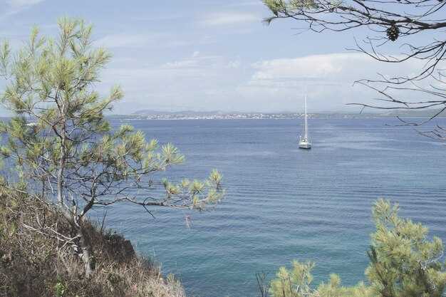
Start with a 7-day coastal loop that begins in Olbia and heads toward La Maddalena, delivering a first taste of Sardinia’s azure bays. Hire a capable boat for 2–4 guests, keep daily legs in the 20–35 nautical mile range, and you’ll enjoy a pearl-like mix of coves, charming town squares, and calm anchorages.
From Olbia, sail a sheltered leg to La Maddalena, where you can swim in turquoise water and explore the old town’s marina. In the afternoon, visit Caprera with its pine forests and quiet coves, or swing to Santa Teresa di Gallura to stroll the waterfront, pop into a portside bakery, and sample handmade gelato while chatting with locals visiting the harbor.
Continuing along the northern arc, anchor near Porto Cervo and Cala di Volpe, then ease toward the eastern Gulf of Orosei. A swim in azure coves, a stroll through a sunny town square, and snorkeling around shipwrecks tucked into sheltered reefs add intrigue to the day.
As you head toward the southern coast, drop anchor near Cagliari’s historic harbor and wander the maze of alleys in the Castello district, with nearby tavernas offering fresh seafood. A morning market, a lunch of bottarga, and an afternoon sail toward Villasimius or Costa Rei deliver exceptional scenery and calm water. For a final touch, anchor near Portoscuso at sunset and observe the rocky headlands glow.
With a number of routes and time-saving options, this itinerary fits a range of wind patterns and sea states. Where you anchor, nearby towns invite you to stroll the waterfront, sample seafood, and plan a second visit. The southern leg reveals a different mood–hushed coves, rugged cliffs, and sunsets that feel like a pearl in a marine canvas. If conditions shift, habe a backup plan and adjust to a sheltered bay; the day doesnt have to follow a rigid map, and that makes the route truly intriguing.
Sardinia Sailing Itinerary
Begin with La Maddalena archipelago for a sheltered, special start that yields easy anchorage and a network of marinas.
-
Day 1: Olbia to La Maddalena archipelago
- Sail along the northeast coast into protected waters, choosing Cala Gavetta or Cala Spalmatore for a calm first mooring.
- Explore the medieval town of La Maddalena and Caprera, soaking up the ambience and recording a few clear waypoints for them to reference later.
- Ask giuseppe at the marina for help with weather checks and the best routes along sardinias coast.
-
Day 2: La Maddalena to bonifacio ( Corsica )
- Cross the pass to bonifacio, watching for currents between Sardinia and corsica.
- Dock in the francese-influenced harbor, where the backdrop of white cliffs and ancient walls frames a striking scene.
- While you stroll the old town, enjoy fresh seafood and the quiet ambience before the next leg.
-
Day 3: bonifacio to lavezzi
- Head toward lavezzi, a protected marine area with small, intimate anchorage options among the islets.
- Keep to short hops between coves to minimize wake and maximize sheltered time in crystal water.
- Use a mark on the chart for a late-afternoon stop and enjoy the stillness above the seabed.
-
Day 4: lavezzi to southeast Sardinia ( Villasimius / Costa Rei )
- Proceed southeast along the Sardinian shore, selecting a stop in Villasimius or the Costa Rei marinas for a lively yet protected base.
- Enjoy the ambience of seaside taverns and local shops, then settle into a quiet anchorage for the night.
- Note how the coastal roads frame distant hills, giving a sense of continuity between sea and land.
-
Day 5: Villasimius to Cagliari
- Slip into Cagliari’s marinas, where a sheltered harbor awaits and town life is an easy reach by tender.
- Stroll through the Bastion and marina area, sampling seafood and pausing at shops along the water’s edge to mark souvenirs.
- Keep a flexible schedule to catch a sunset over the Poetto backdrop, then rest in a protected anchorage nearby.
-
Day 6: Cagliari to Golfo di Orosei (Ogliastra)
- Chart a course north to the Gulf of Orosei, with standout anchorages near Cala Luna or Cala Goloritzè when conditions allow.
- In the afternoon, drop anchor near secluded coves and savor the marine clarity and rugged coastline.
- Adjust plans if seas rise; this segment rewards patience with calmer water and dramatic scenery.
-
Day 7: Golfo di Orosei to Olbia or return loop along sardinias east coast
- Return toward Olbia by following the east coast’s bays and roads, stopping at a final anchorage to celebrate the week.
- Review the chart, make notes for a future mark, and reflect on the week’s highlights across the Sardinian coast.
Last-leg start point, optimal departure time, and routing for Friday
Depart Cala Gavetta, La Maddalena, at 08:50 local time. Sail northeast along the protected front of the maddalenas archipelago, avoiding the lavezzi shoals to the south, and steer toward Porto Cervo to follow the coast. This choice delivers a scenic, dazzling backdrop of cliffs, coves, and shimmering water, with the afternoon sun creating beautiful color on the shorelines.
Distance Cala Gavetta to Porto Cervo: 40-45 NM. Target 6.5-7.5 hours at 6-7 knots; ETA around 15:20–15:45. Mark Capo Ferro as the turning point, then continue along the coast to Porto Cervo marina for a lunch and fuel break before the next leg.
Porto Cervo to Olbia leg runs 25-30 NM in 4-5 hours at 6 knots, with an ETA near 19:30–20:00. Dock Olbia by 20:00, enjoy dinner ashore at a locally-sourced spot, and let the community vibe set the tone for the final evening. The route keeps you close to sheltered coves and ports along Costa Smeralda, exposing a beautiful and shimmering maritime backdrop.
For years, geduldig weather checks help you stay in protected waters, and hatten gusts often ease by the afternoon. If wind shifts, shorten the leg to Porto Cervo or swing directly into Olbia’s outer harbor; also keep a backup stop at Golfo Aranci. Carry a small book for notes on marks, tides, and timings. This plan pairs maddalenas charm with Olbia’s ports, presenting two worlds of beauty and practicality, and ends with a dinner that highlights locally caught seafood.
Final-night mooring options: harbors, tides, and docking tips
Pick a protected harbor for your final night–Olbia or Golfo Aranci are solid, easy-to-reach options that keep seas calm and docking straightforward. This choice will give you quick access to water, fuel, and a delightful boutique dining scene, plus a center of shops and caprerabudelli tasting rooms along the quay. The utmost priority is shelter from swell, so prioritize harbors with solid breakwaters and marina staff who can help if you arrive after hours.
If you crave a coastal cruising vibe while staying sheltered, target inner harbors such as Porto Rotondo or Santa Teresa di Gallura. The guardia costiera can confirm slip numbers and tide windows, and many harbors offer reserved berths for late arrivals. On Tuesday and Saturday evenings, some marinas report lighter traffic, which makes final-night stays calmer and easier. From these places you can stroll to intriguing waterfront boutiques and enjoy a glass of local wine. Some locations also offer caprerabudelli tastings and other small delights you can savor after docking.
Tides in Sardinia stay modest, but you still need to time your approach. Plan arrivals near slack water if possible and verify with the marina center before you depart, as a calm entry reduces risk of contact with other vessels. Use the local tide table and wind forecast to predict swells above the quay; this information helps you select the best berth. A quick check at the center will also help you locate a protected slip near the center of the marina.
Docking tips for the final night: approach slowly from the seaward side, align with the fingerprint, and keep a short, steady swing if gusts arrive. Deploy soft fenders and angle two lines to bow and stern cleats, plus a spring line to control drift. Call the guardia or the marina office when you’re five minutes out so staff can guide you to the right slip. In protected harbors, berths are available for visiting yachts; verify depth and clearance with the dock master before you tie off. In most harbors, berths accommodate average cruising yachts; confirm the slip size with the center desk to ensure a smooth fit.
After you secure the boat, stroll to the quay for a breathtaking sunset and a delightful finale. Watch for creatures–seabirds and crabs skittering along the pilings–and savor hatt en pastries with caprerabudelli at a sea-front boutique. This experience, from the intriguing market to the quiet harbor lights, offers a memorable end to a coastal cruising itinerary. vivre the moment, this final night in Sardinia will stay with you long after you depart the places you visited.
Weather, wind shifts, and safety checks for Day 7
Check the 48‑hour forecast and set a contingency plan for wind shifts on Day 7, then secure one reliable mooring in a protected bay before the first gust arrives.
Day 7 runs along the northeast side of Sardinia with Corsica nearby; the mediterranean breeze shifts through the day, and funnel effects between headlands can tighten gusts. Corsica boasts rugged coastlines and famous rock formations that concentrate wind in narrow channels, so expect wind shifts near shore and gusts that can surprise a line of moorings. The francese coast adds micro‑currents that can alter boat speed on small triangles of water, so plan for changes that affect both sides of the boat.
In the morning, anticipate a northeast tilt around 12–18 knots, rising to 18–25 knots by midday, with occasional bursts to 28 knots in sheltered channels. By late afternoon the wind can back toward the southwest or west as thermal heating builds, which changes the sail plan and requires quick reefing. Those shifts create brief lulls suitable for sunbathing on deck, but they also demand steady vigilance when approaching rocks, bays, and protected harbours that often double as sheltered flotilla moorings.
Safety checks flow from the forecast into action: verify that all crew members wear life jackets when gusts sharpen, secure harness lines for those on deck, and keep a tether ready near the helm. Maintain a ready weather watch with VHF on channel 16 and a backup handheld radio, because timely alerts save moments if a shift comes quickly. Conduct a quick engine check and confirm steering responsiveness, bilge pump readiness, and sail‑trim reef lines; changed conditions require fast sail alterations and clear communication among crew on every person onboard. That thats why a compact, practiced routine matters more than a lengthy plan.
Κατά τον σχεδιασμό ελιγμών κοντά στην ακτογραμμή, προσδιορίστε εκ των προτέρων τις προστατευμένες περιοχές και σημειώστε ποιες είναι κατάλληλες για τη στρατηγική αγκυροβολίας του στολίσκου. Οι πιο διάσημοι όρμοι προσφέρουν ήρεμα νερά για διαλείμματα ηλιοθεραπείας, αλλά μόνο αφού επαληθεύσετε την προστασία από το ρεύμα και την αλλαγή του ανέμου. Χρησιμοποιήστε τα σηματοδοτημένα αγκυροβόλια και τις καθιερωμένες προσβάσεις σε αυτές τις προστατευμένες περιοχές για να μειώσετε τον κίνδυνο για την ομάδα και παρακολουθήστε τα σημεία ύφαλων και τα βραχώδη προεξοχές που σχηματίζουν επικίνδυνες πλευρές εάν η πρόγνωση επιδεινωθεί.
| Checklist item | Details | When |
|---|---|---|
| Καιρικές συνθήκες και μεταβολές ανέμου | Επιτήρηση ΒΑ 12–18 κόμβοι πρωί, ριπές 28 κόμβοι στα κανάλια· προσοχή σε μετατοπίσεις προς ΝΔ/ΔΝΔ αργά την ημέρα· φαινόμενα διοχέτευσης κοντά στις ακτές της Κορσικής | Από το πρωί έως το απόγευμα |
| Θέσεις ελλιμενισμού και σχέδιο στολίσκου | Επιβεβαιώστε προστατευμένους όρμους, επαληθεύστε διαθέσιμους λιμενοδέτες, δέστε προκαταβολικά τα φτερά, συντονίστε το χειρισμό των σχοινιών για πολλαπλά σκάφη | Before departure |
| Εξοπλισμός ασφαλείας | Σωσίβια σε όλους τους επισκέπτες, εξαρτύσεις έτοιμες, πλωτή συσκευή, ασύρματοι VHF φορτισμένοι | Πριν τον απόπλου και κατά τη διάρκεια του ταξιδιού |
| Πλοήγηση και επικοινωνίες | Χάρτες βορειοανατολικής Σαρδηνίας και περιοχών διοχέτευσης Κορσικής· έλεγχοι AIS/GPS· ετοιμότητα στο κανάλι 16 | Morning |
| Συστήματα σκάφους | Έλεγχος κινητήρα, τιμόνι, σχοινιά μαζέματος πανιών, δοκιμή αντλίας σεντίνας | Πριν τον απόπλου |
| Crew readiness | Ανάθεση ρόλων για αλλαγές ανέμου, επιβεβαίωση καθηκόντων χειρισμού σχοινιών, ενημέρωση για την ηλιακή προστασία και την ενυδάτωση | Πριν τον απόπλου |
Σημεία πλοήγησης: ακριβές ίχνος, ορόσημα και χρονοδιάγραμμα για τον αυριανό ιστιοπλοϊκό πλου
Αναχώρηση από τη μαρίνα του Αλγκέρο στις 08:00, πορεία 306° κατά μήκος της δυτικής ακτής, παραμείνετε 1 NM από την ακτή για λόγους ασφαλείας και για να κρατήσετε τα θαλασσοπούλια στην πλώρη. Χρησιμοποιήστε αυτά τα σημεία πορείας για να διατηρήσετε μια ακριβή πορεία, με ελέγχους ορόσημων και εκτιμώμενα παράθυρα άφιξης που ταιριάζουν σε μια χαλαρή αλλά αποτελεσματική μέρα στο νερό.
- WP1 Φάρος Capo Caccia – απόσταση 9 NM, πορεία 306°. Σημείο αναφοράς: λευκός φάρος σκαρφαλωμένος στον βράχο· το ακρωτήριο έδειχνε εντυπωσιακό καθώς η αυγή φώτιζε τον βράχο. ETA 09:30 με 5,5–6,0 κόμβους. Σημειώσεις: περάστε 0,8 NM από την ακτή για να αποφύγετε τους βράχους· προσαρμόστε για τις αλλαγές του ανέμου.
- WP2 Είσοδος δυτικά της Isola Piana – απόσταση 8 NM, πορεία 288°. Σημείο αναγνώρισης: Isola Piana με αβαθή κατά την προσέγγιση. ETA 11:00; ταχύτητα 5,5–6,0 κόμβοι. Σημειώσεις: επιβεβαιώστε τα ασφαλή νερά με το βυθόμετρο. προσέξτε για καλάμια ψαράδων κοντά στην άμπωτη.
- WP3 Ακρωτήριο Πόρτο Κόντε – απόσταση 6 NM, πορεία 296°. Σημείο αναφοράς: πευκόφυτο ακρωτήριο, με τη μικρή μαρίνα του Πόρτο Κόντε σε θέα. ΕΤΑ 12:15; ταχύτητα 5,5–6,0 κόμβοι. Σημειώσεις: προστατευμένα νερά μπροστά· ετοιμαστείτε για στάση για φαγητό αν χρειαστεί.
- WP4 Όρμος Cala Reale – απόσταση 5 NM, πορεία 281°. Σημείο αναφοράς: η παραλία με τη λευκή άμμο του όρμου κρυμμένη ανάμεσα σε βράχους· ιδανική για ένα απλό διάλειμμα ηλιοθεραπείας. ΕΤΑ 13:45· ταχύτητα 5,0–5,5 κόμβοι. Σημειώσεις: αγκυροβόλιο ή πρόσδεση στη δυτική πλευρά· ελέγξτε το παλιρροιακό ρεύμα.
- WP5 Προσέγγιση La Pelosa (Torre della Pelosa) – απόσταση 14 NM, πορεία 265°. Σημείο αναφοράς: Torre della Pelosa και εμβληματική λευκή άμμος. ΕΤΑ 16:00; ταχύτητα 5,5–6,0 κόμβοι. Σημειώσεις: κάντε κράτηση για πρόσδεση αν αλλάξει ο άνεμος. Το ηλιοβασίλεμα φαίνεται υπέροχο πάνω από το νερό. Προαιρετική στάση για μια σύντομη κολύμβηση ή μια επίσκεψη στα φώτα του θέρετρου για μια βραδινή έξοδο.
Η διαδρομή προσφέρει αρχιτεκτονικούς βράχους, όπως το Capo Caccia, και μια τέτοια άγρια γοητεία που η ακτή φαινόταν ιδιαίτερα φιλόξενη. Ο άνεμος από τα δυτικά σάς βοήθησε να κατευθυνθείτε ομαλά κατά μήκος της ακτογραμμής, πέρα από τη βασική ιστιοπλοΐα, σε ένα ήσυχο, γραφικό τέλος στη La Pelosa. Αυτό το σχέδιο διατηρεί τους πάντες άνετους και με ασφάλεια στο πλοίο, με τις ασφαλιστικές και ναυλωτικές παραμέτρους να έχουν ελεγχθεί πριν από την αναχώρηση. Εάν μια συνάντηση μετακινηθεί την Τρίτη, προσαρμόστε τις ώρες κατά περίπου 30 λεπτά για να φιλοξενήσετε όλο το πλήρωμα και να διατηρήσετε το πρόγραμμα σφιχτό για όλους τους εμπλεκόμενους. Η προοπτική περιλαμβάνει ηλιοθεραπεία, θαλασσοπούλια να πετούν γύρω από την πλώρη και μια βραδιά που αντηχεί με τη γοητεία της Βορειοδυτικής Σαρδηνίας – αξιοθέατα που όλοι μπορούν να απολαύσουν, να επισκεφθούν και να θυμηθούν γύρω από το ακρωτήριο, με τα πανιά σταθερά και το ηθικό υψηλό.
Επίγειο φινάλε: φαγητό, σημεία για ηλιοβασίλεμα και ευκαιρίες για φωτογραφίες μετά τον κατάπλου
Αγκυροβολήστε σε μια προστατευμένη μαρίνα και περπατήστε μέχρι μια παραθαλάσσια τραπεζαρία για ένα υπέροχο δείπνο θαλασσινών με γαλλική έμπνευση, που κάνει το φινάλε στην ξηρά πραγματικά εξαιρετικό. Οι μαρίνες κατά μήκος της ακτής φιλοξενούν παρόμοιες επιλογές, ώστε να μπορείτε να επιλέξετε την ατμόσφαιρα που σας αρέσει.
Επιλέξτε μια αμμώδη βεράντα κοντά στη μαρίνα όπου έχετε μια πράσινη λάμψη από φανάρια και άμεση θέα στο νερό. Στις μαρίνες της νοτιοανατολικής ακτής της Ιταλίας, αναζητήστε χώρους που συνδυάζουν καταπράσινους κήπους με θαλασσινό αεράκι. Παραγγείλτε ψητό λαβράκι με λεμόνι και μια francese beurre blanc και, στη συνέχεια, ολοκληρώστε με μια πάνα κότα. Ένα τραγανό Vermentino από την περιοχή ταιριάζει καλύτερα από ένα βαρύ κόκκινο, ειδικά μετά από ένα υπεράκτιο ταξίδι. Για μια σύσταση, προτείνω να επιλέξετε ένα τραπέζι με αντανακλάσεις στο νερό.
Σημεια για το ηλιοβασίλεμα: Για το ηλιοβασίλεμα, στοχεύστε ένα πράσινο ακρωτήριο κατά μήκος της νοτιοανατολικής ακτής ή τη δυτική προβλήτα της μαρίνας, όπου ανθίζουν τα χρώματα του άστρου και η θέα εκτείνεται προς τους κόσμους πέρα από αυτόν. Οι λάτρεις της φωτογραφίας θα εκτιμήσουν τις μακριές σιλουέτες και το απαλό φως.
Ευκαιρίες για φωτογραφίες μετά τον ελλιμενισμό: αποτυπώστε τις αντανακλάσεις της γάστρας στην προκυμαία, πλαισιώστε τον αρχαίο πύργο σκοπιάς πίσω από την καταπράσινη ακτογραμμή και χρησιμοποιήστε την άγκυρα ως σιλουέτα πάνω στο λαμπερό νερό. Τραβήξτε ακριβώς την μπλε ώρα από το τέλος της προβλήτας προς τα νοτιοανατολικά για να συμπεριλάβετε λίγα σημεία αστέρων και τους κόσμους στην απόσταση.
Περάστε τις τελευταίες ώρες με τον καπετάνιο σας και μια χούφτα ναύτες. Μοιράζονται συμβουλές για καλύτερες γωνίες και συγχρονισμό. Κάντε μια σύντομη βόλτα προς τα σημεία θέας του ακρωτηρίου κατά μήκος της άκρης του ακρωτηρίου για εντυπωσιακά καρέ ή μείνετε στην αποβάθρα αν προτιμάτε τη λάμψη των μαρινών. Αν θέλετε να κολυμπήσετε, επιλέξτε έναν προστατευμένο όρμο. Τα αεράκια της θάλασσας διατηρούν τον αέρα φρέσκο καθώς ανάβουν τα φώτα.