

 Top 9 Pristine Lakes in Minnesota – Absolutely Stunning, Crystal-Clear Waters">

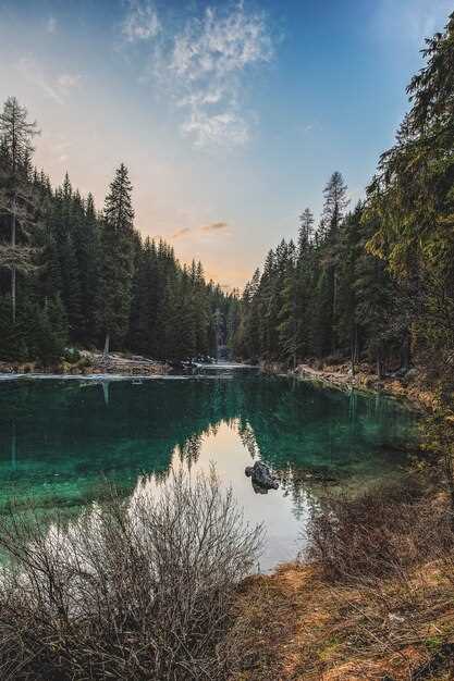
Besuchen Sie zuerst die Quellflüsse für einen ruhigen, praktischen Start Ihrer Reiseroute, wo Hechte durch seichte Ufer gleiten und das Wasser erste Andeutungen von Klarheit offenbart. Wer die Einsamkeit sucht, wird Ruhe und weite Flächen oberhalb des Schilfs entdecken, die zu längeren Aufenthalten und tiefergehender Erkundung einladen.
In der Itasca-Region erstrecken sich diese neun Gewässer in großer Vielfalt: wiesenumsäumte Buchten, Granitfelsen und schneebedeckte Ufer. Die Tierwelt, die Ihnen begegnet, ist echt: Seetaucher, Haubentaucher und kleine Säugetiere entlang der Untiefen; größere Chancen, morgens leuchtende Vögel zu sehen. Wer sich nach ruhigen Plätzen sehnt, könnte das Gefühl haben, dass diese Gewässer mir gehören, nur mit dem frühesten Licht und der Wildnis im Inneren geteilt.
Der Zugang ist unkompliziert. Für vorbereitete Entdecker: gut ausgebaute Wanderwege, Kanurouten und winterliche Anstiege an Schneewehen. Wenn Sie einen Besuch planen, führen Sie eine Karte mit sich und beachten Sie die Hinweisschilder; dieses erschlossene Netz fühlt sich immer noch abgelegen an, ist aber dennoch für einen Tagesausflug abseits der Menschenmassen erreichbar.
Jeder Ort bietet Ruhe und Aussichten, die sich lebendig und vital anfühlen, mit Quellflüssen, die ein riesiges, vernetztes System speisen. Wenn Sie auf Erkundungstour gehen, betreten Sie eine Landschaft, die mehr als nur eine Kulisse bietet – Hechtlöcher, klare Spiegelungen und Wildtierpassagen, die zu wiederholten Besuchen einladen.
Praktischer Überblick: Unberührte Seen in Minnesota für einfache Planung
Wählen Sie die Gegend um Vermilion als Ziel für ein ruhiges, familienfreundliches Wochenende; die Erkundung der umliegenden Küstenlinie bietet reichlich Ausblicke, wobei Hütten und Grundstücke sowohl für bescheidene Budgets als auch für größere Gruppen zur Verfügung stehen.
Im St. Louis County, innerhalb eines Radius von 25 Meilen, befinden sich mehr als 50 Gewässer, darunter das Crane Lake System, das ruhige Buchten und mit Kiefern bewaldete Ufer bietet; der Zugang ist an mehreren öffentlichen Rampen begrenzt, daher ist es ratsam, im Voraus zu buchen; die umliegenden Gemeinden bieten Restaurants, Bootsverleih und geführte Optionen, darunter auch Touren unter der Leitung von Frauen.
Planen Sie Besuche, die sich über das gesamte Wochenende oder mehrere Tage erstrecken und mehrere Gebiete umfassen; jeder Ort bietet ein ruhiges Leben mit familienfreundlichen Aktivitäten und einfachen Wegen entlang der Küstenlinie; der Aufenthalt in einer einzigen Unterkunft in Wassernähe reduziert die Reisezeit und Anstrengung und maximiert gleichzeitig die Zeit im Freien.
Wählen Sie für die Logistik einen idyllischen Stützpunkt in der Nähe von Vermilion oder Crane Lake; dieser Ansatz hält den Namen der Immobilie einfach und die Gegend leicht navigierbar; zu den Unterkunftsmöglichkeiten gehören Hütten mit privatem Uferzugang und Nähe zu Geschäften.
Sicherheit und Erhaltung: Respektieren Sie Minen-nahe Standorte und ausgewiesene Beschränkungen; beachten Sie die Ruhezeiten und schützen Sie das Ufer; das Hinterlassen keiner Spuren unterstützt das umliegende Leben von Gemeinschaften, die für Erholung und Einkommen auf diese Gebiete angewiesen sind.
Zugänge und Parkplätze: Wo man an jedem See zu Wasser lassen kann

Für den schnellsten Zugang und die palettenfreundlichsten Parkplätze nutzen Sie die öffentliche Hauptrampe am North Bay Park am Lake 1 – sie bietet eine breite Zufahrt, schnelles Entladen und einen ruhigen Morgen für eine beliebte Segel- oder Angelsession.
-
See 1 – Hauptzugang: Öffentliche Rampe North Bay Park. Parken: ca. 40 Stellplätze, 4 barrierefreie Plätze; Tagesgebühr ca. 5 $; Öffnungszeiten 5:00–21:00 Uhr. Sofort startklar mit einer glatten Betonoberfläche und einem schwimmenden Dock. Begrenzungsbojen markieren sichere Zonen und halten das Geschehen innerhalb einer klar abgegrenzten Wasserfläche; der Blick auf die sanfte Uferlinie bietet eine idyllische Kulisse für ein Nachmittagsabenteuer.
- Zugangsdaten: 8,5 m breite Rampe, flache Rampenneigung, 6 Klampen am mittleren Dock; ideal für kleine bis mittelgroße Wasserfahrzeuge, einschließlich Segelboote.
- Tipps: Kommen Sie früh an, um Menschenmassen zu vermeiden; Kontakte in der Nähe auf dem Campingplatz des Parks verfügbar; die Zeit, die am Ufer verbracht wird, ist minimal für eine schnelle Fang-und-Freilassungs-Session.
- Anziehungspunkt: Sowohl Touristen als auch Einheimische werden das ruhige Wasser und den Übergang von der Uferlinie zum Wasser, der das Auswerfen einfach macht, zu schätzen wissen; Experten bezeichnen dies als einen beliebten Ausgangspunkt für ungezwungene Ausflüge.
-
See 2 – Zugangspunkt: East Bluff Marina Rampe. Parken: 52 Stellplätze, 6 ADA-Plätze; Gebühr: 1 $ pro Tag; Öffnungszeiten: 6:00–22:00 Uhr. Bietet eine robuste Rampe und einen langen Fingersteg, der das einfache Verladen größerer Boote unterstützt; die Szenerie bietet eine hoch aufragende Kulisse aus Kiefern und Felsvorsprüngen.
- Startinformationen: Rampenbreite ca. 9,75 m; Wassertiefe in der Nähe des Endes nimmt schnell zu und bietet Platz für größere Skiffs.
- Strategien: am besten während später Vormittagssitzungen mit ruhigeren Wasserbedingungen; ideal zum Angeln und für leichte Segelabenteuer.
- Ausstattung: Stromanschlüsse in der Nähe, Toiletten und ein Ausgangspunkt für kurze Pausen im Freien; die Aussicht entlang der Bucht ist durchgehend ansprechend.
-
See 3 – Zugangspunkt: West Ridge Boat Landing. Parken: ~30 Stellplätze; 2 Behindertenparkplätze; stündliche Parkbenutzungsgenehmigungen; Öffnungszeiten 5–20 Uhr. Bietet eine einfache Rampe mit einem geschützten Dock; Begrenzungsmarkierungen halten Sie innerhalb sicherer Zonen, während Sie die ruhigen inneren Kanäle erkunden.
- Zugangsdaten: 7,9 m breite Rampe mit kurzem Übergang von Rampe zum Dock; gut geeignet für Kanus bis mittelgroße Boote.
- Hinweise zur Nutzung: Beliebt für das frühmorgendliche Angeln und kurze Fahrtstrecken; zeitsparend für eine schnelle Runde im Freien.
- Bedeutung: Experten weisen darauf hin, dass diese Einführung ein verlässlicher Anker für Familien ist, die einen idyllischen, unaufgeregten Ausflug mit starkem touristischem Reiz suchen.
-
See 4 – Zugangspunkt: South Fork Park Rampe. Parkplätze: 45 Stellplätze; 3 ADA-Stellplätze; optionaler Nachttarif; Öffnungszeiten 4:00–21:00 Uhr. Die Rampe wird von einem Parkstreifen mit einem langen, komfortablen Dock begrenzt–ein ausgezeichneter Ausgangspunkt für ein Abenteuer in ruhigere Buchten.
- Zugang: 8,8 m breite Betonrampe; einfaches Verladen für mehrere Wasserfahrzeuge; flacher Einstieg in Ufernähe, der allmählich tiefer wird.
- Am besten geeignet für: Angeln und Segeln; die Grenzmarkierungen grenzen stark frequentierte Wasserwege ab und sorgen so für ein ruhiges und sicheres Erlebnis.
- Ausstattung: Anschlüsse in der Nähe der Anschlusspunkte des Parks verfügbar; nahegelegene Picknickplätze erhöhen die Attraktivität.
-
See 5 – Zugangspunkt: Blueview Cove Launch. Parken: 38 Stellplätze; 4 ADA-Plätze; Genehmigung an Wochenenden erforderlich; Öffnungszeiten 5:00–22:00 Uhr. Bietet eine breite Rampe und einen langen Pier mit weitem Ausblick und ruhiger Atmosphäre für einen entspannten Morgen auf dem Wasser.
- Hinweise zum Stapellauf: Rampenbreite ~8,5 m; das Dock verfügt über mehrere Klampen zum einfachen Festmachen; Begrenzungsbojen helfen bei der Trennung der Angelbereiche.
- Outdoor-Fokus: Ideal für Angler und Segler, die eine ruhige, geschätzte Umgebung mit einer malerischen Küstenlinie suchen – ein Favorit unter Einheimischen und Besuchern gleichermaßen.
- Ausstattung: Stromanschlüsse und Toiletten; Attraktionen am Wasser sind unter anderem ein kleiner Boardwalk für Besichtigungen und Fotografie.
-
See 6 – Zugangspunkt: Sunset Bluff Ramp. Parken: 50 Stellplätze; 2 ADA-Plätze; Saisonale Genehmigung; Öffnungszeiten 6:00–21:00 Uhr. Die Startrampe befindet sich oberhalb eines bewaldeten Vorsprungs und bietet eine dramatische Grenze zwischen Ufer und Wasser sowie eine fertige Bühne für abendliche Ausblicke.
- Zugang: 9 m breite Rampe; stabiler Pier, großzügige Ladezone; flaches Wasser in Ufernähe erleichtert sanftes Zuwasserlassen.
- Beste Zeit: Segeln am späten Nachmittag oder Uferangeln; die Landschaft wird besonders reizvoll, wenn die Sonne hinter den Kiefern untergeht.
- Tipps: Treffen in der Nähe im Campingbereich; Touristen suchen häufig nach Möglichkeiten in nahegelegenen Buchten.
-
See 7 – Zugangsstelle: Golden Dune Launch. Parkplätze: 28 Stellplätze; 1 Behindertenparkplatz; Öffnungszeiten 5–20 Uhr. Eine kompakte Rampe, umgeben von Dünen, schafft eine immersive, idyllische Atmosphäre, ideal für Anfänger- bis Mittelklasse-Boote.
- Details zum Zugang: 7,5 m breite Rampe; die Anlegeleinen sind deutlich markiert; die Grenzmarkierungen sind von der Ladezone aus sichtbar.
- Highlights: Bietet eine malerische Umgebung, perfekt für einen ruhigen Morgen im Freien; betont die Vielfalt des Angelns und das Abenteuer einer Kurzkreuzfahrt.
- Ausstattung: mobile Toiletten, Picknicktische und Stromanschlüsse; Experten weisen darauf hin, dass dies ein hochwertiger, leicht zugänglicher Ausgangspunkt für einen Kurztrip ist.
-
Lake 8 – Access point: Quiet Hollow Public Ramp. Parking: 36 stalls; 3 ADA places; hours 5am–9pm; fee $4. This site is known for its calm water and a generous shoreline–great for a tranquil day on the water with ample views.
- Launch: 26 ft-wide ramp; shallow ramp-to-water transition; ideal for canoes and small boats seeking a short, smooth launch.
- Best moments: morning fishing and light sailing, when the water is glassy and the boundary is easy to navigate.
- Extras: hookups available in nearby campground; attractions along the shore include a wildlife overlook and picnic areas.
-
Lake 9 – Access point: Northshore Landing. Parking: 60 stalls; 5 ADA spots; hours 5am–11pm; season pass option. This big-site ramp yields abundant space for bulk launches and frequent gatherings, making it a strong anchor for longer days outdoors.
- Access: 34 ft-wide ramp; wide dock; landing zone well-marked; the water depth quickly reaches a comfortable level for many craft.
- Strategy: ideal for advancing sailing skills or chasing a multi-hour fishing stint; observers will delight in expanding views of the water and shore.
- Facilities: full hookups, restrooms, and a small shop nearby; experts highlight this spot as a key attraction for families and visiting tourists.
Best Time to Visit for Clear Waters: Seasonal Windows by Lake
Plan to visit in late spring or early fall for the calmest, most glassy surface and best visibility, a window that lasts several months and supports planning more than a single morning with local guides.
Spring turnover can muddy the earliest days, so target the window a week or two after ice-out, and keep checking the источник for the latest conditions. This content highlights nature’s firsts–diverse birds around woods and bald bluffs–and points you toward the best values for viewing and photography.
Early summer offers a favorable blend of warmth and light winds. Months from May to June deliver calmer mornings, ideal for sailing and for routes along coves toward islands. If you want something reliable for pike fishing, target dawn hours when the water is still and reflections are sharp. In addition, consider the property of public launch sites when planning access.
Mid-summer tends to host longer days but occasional storms; mornings stay calm, making it easier to chart routes, explore coves, and tie up near a small island or two. The pike and other residents are more active after dawn, and the surface often looks like polished glass when winds are light.
Fall delivers dramatic color and reduced traffic. Autumn falls bring quiet days; leaves drop, eagles ride the thermals above bald pines, and coves hold clear water on still mornings. This is a good time for dreaming up a short, successive route–some days with ideal visibility, some with a hint of color on the horizon–so plan with a local map and be ready for updates.
Winter offers limited open-water chances; some lacs and ponds freeze to mirror-like surfaces, presenting striking scenes. When planning trips, check safety rules for property access, and consider a winter scouting of routes around the woods and around any island silhouettes. In addition, you can use this time for content review and draft a spring plan to match the next firsts of the season.
Boat Launch Rules, Permits, and Responsible Etiquette
Always verify permit requirements with the local park office before launching; carry proof and be prepared for day-use fees at the ramp area near headwaters access. For convenience, arrive early and park in designated zones to minimize congestion for multiple users, including kayakers and family groups.
- Permits and registrations: Confirm vessel registration and any park or fishing licenses; in the minnetonka corridor and pepins region, a county pass may be required for parking and access; check the issuing authority’s site before visiting.
- Ramps and load order: Use only designated ramps; back the trailer straight, remove loose gear away from the waterline, and have a spotter if the line is long or the shore is busy.
- Safety equipment: Each person on board wears a PFD; keep a whistle and a light for low visibility; prepare a throw bag when boating in deeper headwaters or lake channels.
- Launch and recovery flow: Move with purpose into the body of water; yield to kayaks and paddlers; do not block the ramp; if a vessel is retrieving, stay clear and wait for your turn.
- Clean, drain, dry policy: Inspect and remove aquatic plants or animals; rinse hulls and gear, drain bilges, and dry equipment to prevent spreading an invasive species along the shoreline or into other water bodies.
- Shoreline and wildlife etiquette: Maintain a slow no-wake speed near the shore; avoid disturbing birds or nesting sites and give space to any caribou herds or other wildlife observed on shorelines; keep pets under control.
- Wildlife and species notes: In waters where sturgeon occur, reduce speed and avoid creating wake in sensitive habitats; fall migrations bring birds into the area, so keep noise low and observe from a distance.
- Regional notes and etiquette: If you are visiting with family, choose family-friendly ramps that provide easy access and clear signage; these options offer convenient parking and well-marked paths to water, contributing to a quality experience for visitors among the lush shoreline scenery around minnetonka and pepins.
- Post-visit responsibilities: Always drain, clean, and dry gear before moving between water bodies; the practice provides a simple way to protect headwaters and multiple body of water systems and keeps near water quality high for everyone, sure to benefit birds, fish, and humans alike.
Pro tips for practical action: arrive during off-peak hours (early morning or late afternoon) near the shorelines to reduce action conflicts, keep launches near the headwaters clean, and ensure that your load is balanced for a smooth entry into the water. Would-be visitors would appreciate a cadence that minimizes crowding and protects the surrounding habitat, especially in fall when birds and other wildlife are most active and the lush banks along minnetonka and pepins showcase pristine viewing opportunities for families and solo explorers alike.
Booking Your Boat: How to Use Getmyboat for a Lake Day
Begin by checking Getmyboat listings for your date, then set filters: pickup near your town, focus on headwaters routes, and choose a vessel with captain if you want guided adventures. This approach keeps the planning footprint small and lets you enjoy the day without worrying about navigation.
Filter by features: wakeboarding, fishing, roomy deck, shaded seating, cooler, stereo. For these first-timers or those seeking calm vibes, a roomy pontoon with sun shade delivers an easy outdoors experience.
Review pricing and terms: price per hour or per day, deposits, cancellation policy, and fuel policy. Check if delivery is available to Gunflint docks or near itasca listings, and look for options that align with your schedule and budget. This is your opportunity to tailor to your plan with only a few clicks.
On day-of, confirm pickup spot, show up with ID, and check safety gear. Checking includes life jackets for every rider, a throw rope, and a first aid kit. If you plan to reel in fish, bring a reel and light tackle. Some listings include gear, others let you bring your own.
Consider the locales: Gunflint shores, headwaters regions, and other lush settings offer different backdrops. While you’re browsing listings, check the setting and the outdoors scenery. These firsts and opportunities arise when you pick a listing with flexible times and a capable crew. You can visit buzzy towns or remote inlets, catching views of the expanse and the living world around you, all while planning with an eye toward itasca and nearby spots.
| Listing | Price | Hours | Features | Anmerkungen |
|---|---|---|---|---|
| Caribou Cruiser | $290 | 6 | Pontoon, shaded deck, stereo | Headwaters access; family-friendly |
| Gunflint Glide | $150/hr | 4 | Bowrider, wakeboarding rope, life jackets | Pickup near town; flexible timing |
| Itasca Explorer | $230 | 5 | Deck space, cooler, optional fishing gear | Great for first-timers; easy launch |
Safety, Regulations, and Weather Awareness on Minnesota Lakes
Always wear a U.S. Coast Guard–approved life jacket before leaving shore, and keep it on while the vessel is moving. For outdoor trips, pack a compact safety kit with a whistle, a flashlight, a spare battery, and a throwable flotation device; check the water surface for ripples, currents, or debris. Stay alert for wildlife along the banks; a bear may appear near forests along the shores, especially on trails and in wooded areas.
Regulations demand that every vessel carry standard equipment: PFDs for each passenger, a sound-producing device, approved fire extinguisher, and proper navigation lights at dusk or night. Fishing activities require a current license and adherence to creel limits and species regulations; check for crappie-specific rules, size limits, and seasonal closures. Those running charters should verify operator credentials, insurance, and passenger limits; if you’re near Vermilion, visit the small-town marina office for the latest guidelines and any area-specific restrictions; rules are situated to protect people and the resource.
Weather can be dramatic in summer; a calm morning can switch to strong gusts and high waves on the surface in minutes. Before departure, consult a trusted forecast, set alerts, and carry a VHF radio or a smartphone with offline maps; plan for shelter on shore. If you see dark clouds, lightning, or rapidly dropping barometric pressure, stop activity and move to a secure area away from rock, stone, and other hazards.
Diving and water-entry poses hidden risks near submerged rocks, logs, and weed beds. Always assign a spotter when swimming or diving, test depth with a wader or pole, and avoid shallow bays with visible rock outcrops and stone shoals. Anyone taking photos or visual sightseeing should keep a buffer from shore to prevent capsize. Those new to boating should remain in shallower zones to build confidence.
Those seeking recreational opportunities can take advantage of versatile access points along a broad, calm body of water; the expanse offers attractions from scenic views to fishing for crappie and exploring forests around Vermilion. For convenience, look for marinas with on-site gear rentals and guided charters; near Vermilion, small-town service hubs provide current advisories and safe launch ramps.
Wer Ausflüge plant, sollte Routen entwerfen, die sich über mehrere Buchten erstrecken, die Oberflächenbedingungen über mehrere Abschnitte prüfen und gute Startplätze am Ufer notieren. Behalten Sie bei einer Fahrt an der Oberfläche den Horizont im Auge und organisieren Sie Ihre Ausrüstung so, dass Sie schnell darauf zugreifen können. Erkundigen Sie sich bezüglich Bärenschutz und Wegsperrungen bei den Forstämtern.
Abschließende Kontrollen: Behalten Sie eine gedruckte Karte, ein aufgeladenes Telefon und einen Wetterplan; teilen Sie jemandem Ihre Route mit; halten Sie Notrufnummern bereit; respektieren Sie die ausgeschilderten Attraktionen und Geschwindigkeitsbegrenzungen; haben Sie immer einen Plan, um in Ufernähe zu ankern, falls der Wind auffrischt. Durch die Einhaltung der Vorschriften und die Beachtung des wechselnden Wetters haben Wassersportler mehr Möglichkeiten und ein sichereres Outdoor-Erlebnis.