

 Florida Boating Guide – Where to Boat in Florida – Top Spots">

Start with the Gulf coast corridor around the Tampa Bay area to maximize calm shallows, quick entry, and access to major harbors. This choice minimizes risk and offers reliable wind patterns for a first exploration, with a unspoiled coastline experience and a clear design for safe navigation along coastlines.
Along the Atlantic stretch, a sequence of city hubs forms a practical region for year-round cruising. Incredibly generous shallows and river mouths create a flexible corridor for day trips, with calm bays and beaches feeding culture-rich anchorages. Maintain alert for shifting currents and tidal rates as you move between harbors and inlets.
Von busiest entry points such as Miami, Fort Lauderdale, and Palm Beach, the opportunities for slip availability, fueling, and quick hops along the coast are unparalleled. Here, culture thrives on water traffic, with lively harbors and a strong wind breeze that shapes daily plans. Stay alert to congestion and commercial traffic in major channels.
Beyond the metro corridors, the panhandle and the north Atlantic region offer unspoiled river routes and shallow entry channels. Gestaltung your itinerary with a focus on sheltered harbors and safe moorings; monitor currents and wind forecasts to avoid strong gusts and to align with the prevailing rates for fuel and moorage.
Rankings compiled from anchorages, accessibility, and slip quality place these coastal districts high; for a first-time voyage, target a major port with a shallow approach and a stable slip that can be reserved ahead. The combination of calm shallows, a bustling culture, and diverse river currents makes this route incredibly adaptable for any season.
Choose your region based on wind windows; if forecasts were uncertain, adjust your plan toward calmer passages. The best opportunities lie where traffic, culture, and unspoiled coastline converge.
Top Sarasota Boating Spots and Access Points on Florida’s Gulf Coast
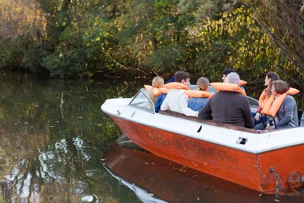
Start at downtown Marina Jack and launches a watercraft for a 2–3 hour loop through Roberts Bay, around Lido Key, and back through New Pass toward Longboat Key; this well-spent plan taps into energy here on the coast and proves ideal for families seeking a safe, wildlife-filled escape.
-
Downtown Sarasota Harbor & Marina Jack – On-site fueling, restrooms, and a short ride to Roberts Bay; this hub makes the first stop for many trips, offering easy access to a protected corridor and skyline views.
-
South Lido Public Access (Lido Key) – Direct gulf-entry ramps into Big Pass; coral formations nearby, ideal for short loops and wildlife watching; parking is limited on crowded days; best at sunrise or late afternoon.
-
Blackburn Point Park Access (Nokomis) – A sheltered entry to the intracoastal route toward residential canals and small islands; carry essentials, enjoy the mangrove canopy, and watch for manatee.
-
Casey Key & New Pass Area – Two linked launch points along a gulf-channel loop; include beach stops and island views; especially good for photographer families; trips lasting 1.5–2 hours.
-
Longboat Key Access Points – Channel launches near Longboat Pass; connect to Anna Maria Island or continue south toward the mainland; beware shallow bars at low tide and follow marked channels.
-
Johns Pass Corridor (for extended trips) – A longer route that channels vessels toward the Panhandle coast; this work requires current maps and local advisories; it broadens options beyond the core Sarasota area.
-
Islands & Wildlife Spots – Siesta Key, Lido Key, and neighboring islets offer beaches, coral patches, and manatee-watch opportunities; families frequently spend time watching dolphins and shorebird roosts; the energy here is widespread and inviting to miamis locals and visitors alike.
News: Always check local advisories before launching; wind shifts and currents can change conditions quickly; carry a VHF radio, life jackets, signaling devices, and a chart; public ramps here generally offer parking and fuel services, and access has become a popular weekend activity, making this area a go-to for residents and visitors who want a quick trips option that can be executed as a loop or as part of a longer cross-coast run.
Ramps, Marinas, and Access Points in Sarasota
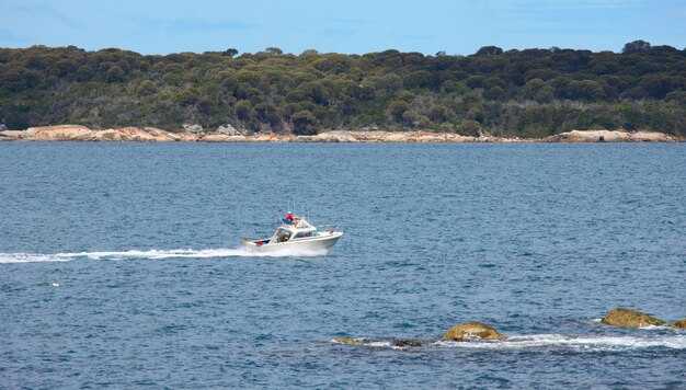
Start your day at South Lido Public Boat Ramp for swift access to gulf passes and calm mornings, then head toward crescent beaches a short paddle away. plan to launch near first light, when winds are mild and reefs and schools of fish are easier to spot from the bow.
Ramps and access points number four main public launches around the island and mainland corridors: South Lido on the island of Lido Key, Nokomis Public Boat Ramp, Siesta Key Boat Ramp near Crescent Beach, and Venice Public Boat Ramp. Operators staff each site with parking, basic docks, and restrooms; remain courteous in busy hours, especially around residential channels their neighbors rely on for quiet mornings.
Marinas anchor the waterfront with tangible services: Marina Jack on the bayfront offers transient slips, fueling, and dining, making it a popular start or stop for swift hops. Residential and smaller private marinas line the inland canals and island backwaters, with their own access points and limited provisioning. Operators here emphasize efficient turnover for recreational craft while keeping safety a priority.
Access points thread the coast from island neighborhoods to the intracoastal, providing straightforward routes to inlets and reef edges. In mornings, plan for light currents and check weather windows; socializing on docks is common, yet respect the pace and space of nearby residents while you coordinate moves with their crews and guests.
For longer ambitions, many skippers map routes toward Jupiter or Lauderdale, timing crossings with favorable winds and the weather. Inland connectors via the okeechobee waterway beckon for multi-day itineraries; confirm current conditions with operators before committing to that leg. From the local ramps, keep a steady plan, watch the reefs and schools, and remain aware of other vessels’ priorities as you share the water from dawn to dusk.
Best Seasonal Routes: Gulf of Mexico vs. Intracoastal Waterway
Opt for a Gulf coast run in late fall through winter for short crowds and vast, uninterrupted banks. A week-long transition to the Intracoastal Waterway offers a convenient, harbor-hopping cruise without crowds. Boaters can combine both routes for a balanced itinerary. One week covers most highlights.
From Tarpon Springs to Naples, roughly 350 miles of navigable coast unfold with mangrove banks and open flats. In the cooler season, water temperatures range around 60–75°F, winds stay light, and beaches along the coast remain enjoyable for day trips. This stretch offers expansive coastal views. Marinas along these stops handle millions of visits annually, amenities included, so booking in advance is wise.
On the Atlantic Intracoastal Waterway, expect a sequence of sheltered passages between barrier neighborhoods, with easy contact points at marinas, shops, and parks. Each neighborhood along the ICW offers unique dining and dockside services. Those seeking a calm, learning-friendly cruise will find a vast corridor of lagoons and inlets around Amelia Island, Jacksonville, Daytona, Cape Canaveral, Palm Beach, and Miami. A local store is available in many towns, and rest stops near communities; this segment examines seasonal wind patterns and crowd trends to help plan windows. Park facilities along the route support restful days. The corridor remains popular with students and families, but you must watch weather and stay within limits for depth and lock spacing. Does this plan fit a student schedule? It does. Those preferring a shorter, predictable cruise can plan a two- or three-day hop between marked channels.
No-Wake Zones, Speed Limits, and Navigation Rules You’ll Encounter
Begin by respecting marked no-wake zones and keeping idle speed along nearshore corridors; thats the quickest way to protect shorelines, seagrass beds, and nesting habitats. Respond to posted signs and buoys, as an abundance of markers helps you stay compliant in bustling coastal waters of the state.
Speed limits are posted clearly; in no-wake zones you must be at idle or at the slowest practical pace. In channels and passes, adjust to conditions–traffic, currents, and wildlife can demand lower speeds. Additionally, monitor weather, wind, and crowds; boater concentration can change quickly in bustling harbors, so plan your approach with caution.
Navigation rules you’ll encounter include right-of-way procedures, safe passing, and signaling requirements. Remember red markers on your right when returning to shore and green markers on your left; keep to the channel center, yield to vessels restricted in maneuverability, and avoid crossing ahead of commercial traffic.
Safety and etiquette: nearshore areas demand respect for crews and visitors alike. For visitors renting gear, keep a safe distance from paddlers and crab pots. Plan a looping route that minimizes back-and-forth traffic; arrange stops at marinas and parks with a compact schedule, and tailor your style to conditions. Maintain proper safety gear and communicate with your crew; college crews and recreational groups often practice in busy bays, contributing to the bustle. If conditions change, respond quickly and adjust.
Erforderliche Sicherheitsausrüstung und Schnellüberprüfungen vor dem Verlassen des Stegs
Zieh für jeden Passagier an Bord vor dem Ablegen vom Steg eine richtig sitzende, von der USCG zugelassene Rettungsweste an. Diese einfache Handlung rettet Leben und trägt dazu bei, die Einhaltung der Vorschriften im ganzen Land sicherzustellen, die je nach Region und Gebiet unterschiedlich sind und einen sicheren Start in Ihre Reise unterstützen.
Diese Checkliste hilft Ihnen, alles abzudecken, was Sie für eine sichere Abfahrt benötigen, und bietet die Möglichkeit, schnelle Übungen mit den an Bord befindlichen Personen zu üben.
- Überfülle von PFDs und werfbaren Geräten: Stellen Sie sicher, dass sich für jede Person an Bord eine von der USCG zugelassene Schwimmweste befindet, zusammen mit einem leicht zugänglichen werfbaren Gerät; Besuchereinheiten sollten die Größen anpassen, um sie schnell anpassen zu können.
- Leichte Geräte: Navigationslicht, Deckslicht und Ankerlicht; überprüfen Sie den Betrieb vor Sonnenaufgang oder Sonnenuntergang und halten Sie eine wasserdichte Taschenlampe mit Ersatzbatterien bereit.
- Feuerlöscher: Typ B:C, an einem zugänglichen Ort montiert; Überprüfen Sie die Messskala und das Inspektionsetikett für das aktuelle Jahr.
- Tonsignalisierung: Pfeife oder Hupe mit Ersatz, plus eine laute Signalisierungsoption für Situationen mit geringer Sichtbarkeit.
- Erste-Hilfe-Kasten: Enthält Desinfektionstücher, Verbände, Gaze, Pinzette und Notfallkontakte; an einem trockenen, zugänglichen Behälter aufbewahren.
- Kommunikationsgeräte: VHF-Radio auf Kanal 16; mondbeleuchtete oder ferne Operationen können sich auf eine Handeinheit verlassen, um Kontakt aufzunehmen, falls die Haupteinheit ausfällt.
- Werkzeuge und Ersatzteile: Bilgenpumpe oder Schöpfkelle, Ersatzsicherungen, Klebeband, Zangen und motorkennspezifische Ersatzteile für diejenigen, die ältere oder regionale Modelle betreiben.
- Bestimmungen für Sicherheit und Komfort: ausreichend Wasser, Sonnenschutz, geeignete Kleidung und rutschfeste Schuhe zum Ein- und Aussteigen an verschiedenen Standorten entlang der Küste.
- Rope and anchor kit: eine lange Länge von Leine zur Rettung nach Mann über Bord (MOB) und ein zuverlässiger Anker mit ausreichender Kette oder Leine, um im gewählten Bereich zu halten.
- Dokumentationspaket: Schiffszulassungsdokumente, Versicherungsdetails und Notfallkontaktinformationen in einem wasserdichten Beutel für schnellen Zugriff bei Bedarf.
- Wetter und Gezeiten: Ziehen Sie aktuelle Vorhersagen von NOAA/NWS ab, prüfen Sie Böen, See und ein mögliches sich änderndes Muster; wenn Warnungen vorliegen, verschieben Sie die Reise, wenn Ihr Schiff die Bedingungen auf der nächsten Etappe nicht bewältigen kann.
- Gefahren und Nähe: Sandbänke, Untiefen, ferne Felsen und Flussmündungen identifizieren; aktuelle Position mit Markierungen und Seekarten überprüfen und in flachen oder überfüllten Gebieten auf fast Leerlaufgeschwindigkeit reduzieren.
- Treibstoff und Reichweite: Berechnen Sie die Verbrauchsraten für Ihre Reisefluggeschwindigkeit; stellen Sie sicher, dass ausreichend Treibstoff für die geplante Strecke plus 25–40% Reserve vorhanden ist; Beispiel: Wenn Ihr Fluggerät bei Reisefluggeschwindigkeit etwa 6 GPH verbraucht und Sie einen Lauf von 2 Stunden planen, nehmen Sie mindestens 15 Gallonen Treibstoff mit, abhängig von der Tankgröße und der Entfernung.
- Systembereitschaft: Testen Sie den Not-Aus, überprüfen Sie die Gasannahme, die Lenkung und den Trimm; starten Sie den Motor und achten Sie auf ungewöhnliche Geräusche; prüfen Sie vor dem Verlassen des Stegbereichs die Bilge auf Undichtigkeiten.
- Beleuchtung und Signalisierung: Bestätigen Sie, dass alle Fahrtlichter und ein Ankerlicht funktionieren; überprüfen Sie, ob akustische Signale für den Betrieb bei Tag oder Nacht funktionsfähig sind; stellen Sie sicher, dass Sie signalisieren können, wenn die Sicht eingeschränkt ist.
- Kommunikationsplan: Halten Sie das UKW-Funkgerät bei Fahrt auf Kanal 16; haben Sie ein Backup-Gerät, um die Marina oder die landesweite Küstenwache zu kontaktieren, falls erforderlich; legen Sie fest, wer bei sich verschlechternden Bedingungen zu benachrichtigen ist, was Ihre Reaktionszeit verbessert.
- Besatzungsbereitschaft: Alle über MOB-Verfahren, Passform der Rettungswesten und Handzeichen informieren; Rollen für an Bord befindliche Personen zuweisen, um die Entscheidungsfindung bei rauem Wetter zu beschleunigen.
- Schwimmplan und Koordination: Teilen Sie einen Schwimmplan mit einem vertrauenswürdigen Kontakt an Land mit; notieren Sie Ihre geplante Route durch das Gebiet und die ungefähren Zeiten; fügen Sie einen Plan zur Änderung der Reiseroute hinzu, falls Gefahren oder die Nähe zur Küste sich ändern.
- Routenplanungs-Hinweis: Wenn Sie in Richtung offenes Wasser nach Osten fahren, behalten Sie die Kanalmarkierungen im Auge und stellen Sie sicher, dass Sie bei steigendem Wind oder Seegang schnell einen sicheren Hafen oder eine Küste erreichen können; vermeiden Sie weit entfernte Routen ohne Anhaltspunkte.
Vermietungen, Charter und lokale Guides für die Gewässer von Sarasota
Beginnen Sie mit einer 4-stündigen Segelcharter im Raum Hillsboro, die einen Stopp an einer Sandbank und eine palmen gesäumte Küste beinhaltet; dieser Testlauf hält Sie innerhalb der Grenzen und bietet eine beeindruckende Einführung in diese Gewässer.
Planung sollte eine Reihe von Optionen präsentieren, die auf die Gruppengröße und das Budget passen; eine Vielzahl von Schiffen reicht von kompakten Segelbooten bis hin zu geräumigen Pontonbooten. Beliebte Optionen sind private Charter und geführte Segelerlebnisse mit flexiblen Routen, die zu Schnorcheln oder Sonnenuntergangsfahrten geändert werden können. Viele Marinas haben einen On-Site-Shop, um zusätzliche Ausrüstung zu mieten oder wichtige Dinge zu besorgen.
Notizen zu Inklusionen: Versicherungsschutz, Schwimmwesten und erforderliche Sicherheitsausrüstung überprüfen; viele Betreiber beinhalten Grundausrüstung, während einige Add-ons wie Schnorchelausrüstung oder Angelruten anbieten. Die Preise variieren je nach Bootsgröße, Dauer und Nachfrage, daher Inklusionen und Stornierungsbedingungen vor der Buchung bestätigen. Das schafft Vertrauen durch klare Briefings und geübte Routen.
Lokale Guides enthüllen Juwelen rund um Hillsboro, Buchten und Seen in Reichweite; sie passen ihre Routen oft an Ihre Szene an, und Richtlinien erlauben Anpassungen bei schlechtem Wetter, während sie einen Skyline-Hintergrund liefern, der an den Sonnenuntergang in Downtown Tampa erinnert. Respekt für Wildtiere und Lebensräume wird erwartet, und Guides helfen Ihnen, sich an die Vorschriften zu halten und gleichzeitig Sicherheit und Genuss zu maximieren.
| Operator | Mietart | Duration | Included | Rates | Anmerkungen |
|---|---|---|---|---|---|
| Sunset Sail Co. | Charters | 4 hours | Rettungswesten, Treibstoff, Basisausrüstung | $320–$520 | Versicherung verfügbar; beliebt bei Familien |
| Sandbar & Palm Tours | Guided Rentals | 2–3 hours | Geführte Route, Sicherheitsbriefing | $180–$260 | Ideal für Anfänger; viele Foto-Möglichkeiten |
| Harbor Stars Charters | Private Charters | 4–6 hours | Boot, Kapitän, Sicherheitsausrüstung | $450–$900 | Enthält Hinweise zur lokalen Tierwelt; flexible Reiserouten |