

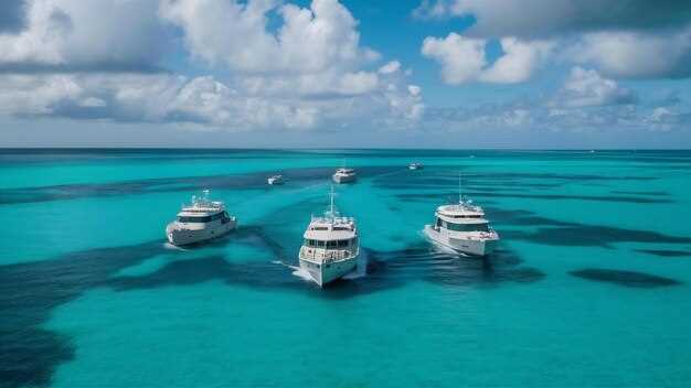
 Nassau to Eleuthera Yacht Charter Itinerary – A 5-Day Bahamas Sailing Route">
Book the Nassau to Eleuthera charter with Harbour Island as Day 1 stop to keep legs under 70 nautical miles and maximize calm mornings. This choice shields you from late-afternoon chop, lets you anchor near Pink Sands Beach, and gives your crew time for a sheltered jízda na kajaku session along coves just east of the harbor. There, you’ll settle into your home base in Nassau, complete the safety briefing, and plan the first leg; consider a possible detour toward the abacos if winds swing favorably there.
Day 2 covers 20–28 nautical miles to Spanish Wells or Governor’s Harbour on North Eleuthera. The morning sea state tends to be calm, with a steady easterly breeze that keeps the boat comfortable along the lee shore. Provisioning is straightforward in Spanish Wells, and a short shore walk pairs well with a sunset jízda na kajaku lap through mangroves. also, if winds cooperate, you can make a brief detour toward johnston for a snorkel stop before continuing to the next port.
Day 3 takes you along Eleuthera’s eastern shore toward Cape Eleuthera and Rock Sound. The scenery blends rugged cliffs with turquoise water, and jízda na kajaku along coves offers a chance to see sea birds and hidden nooks. A late-afternoon vrhnout se into Rock Sound’s Ocean Hole is a standout moment for anyone who loves a refreshing dip after a day at sea.
Day 4 continues to the southern half of Eleuthera, with a stop at Tarpum Bay and a final approach to Governor’s Harbour. Expect glassy water in the morning, then a gentle southeasterly push that makes a beach stop and snorkel viable. For sailors craving a longer arc, a detour to warderick wells, a national park, opens the door to deeper water and calmer anchorages, while the abacos also remain a tempting longer-loop option for future trips.
Day 5 wraps up with a final glide to Governor’s Harbour or a direct run back toward Nassau to complete the charter. Expect a comfortable 4–6 hour sail for this last leg, depending on wind, and plan a last snorkel near a protected cove or a final jízda na kajaku session along the coast. The route reveals incredible beauty: pink sands near Harbour Island, calm bays, and a south coast that feels remote yet welcoming. If conditions permit, you can also stop at johnston or other small cays en route for one last taste of island life before turning the boat in, leaving you hopeful for the next Bahamas adventure.
5-Day Nassau to Eleuthera Route: Practical Sailing Plan
Recommendation: From Nassau, set a short, sun-drenched first leg to Rose Island to test sails, moorings, and comfort, then advance with daily hops of roughly 15–20 miles toward Eleuthera, keeping the pace steady for a catamaran or a sturdy craft.
Day 1: Nassau to Rose Island keeps you in protected waters, with options to anchor in a peaceful cove or use a nearby mooring. Expect clear water suitable for a plunge and a light paddle along shoreline points. Carry a small store of provisions for a couple of days and log tide data from the источник (source) to gauge currents and wind shifts throughout the afternoon. This leg sets a practical baseline for weather windows and sail trim before longer hops.
Day 2: Rose Island to Harbour Island (Alice Town) presents a longer but manageable run with steady trade winds. Plan for 18–25 miles depending on how you ride the v celém conditions. In Harbour Island, explore Pink Sands Beach, walk the shore, and check nearby moorings if weather shifts. If you crave a quick land-based adventure, hike a short trail, then return to the boat for a sun-drenched evening aboard. Keep your water and fuel stores topped off for the next stage.
Day 3: Harbour Island to Spanish Wells (Eleuthera north) is a shorter hop, about 8–15 miles, with ample opportunities to anchor near shore or pick up a mooring. Use the day for snorkeling near offshore reefs, then stroll the nearby town for provisions or a small craft store stop. This stretch benefits from calm morning conditions and a lee shore to minimize drama; plan to purposes of the stop as rest, provisioning, and quick shore exploration, rather than rushing the crossing.
Day 4: Spanish Wells to Hatchet Bay or Palmetto Point on the south coast offers routes that balance distance and scenery; expect roughly 12–22 miles depending on your chosen harbors. In Hatchet Bay, visit the noted caves for a dry-land excursion, then return to the boat to vrhnout se into clear water or paddle along sheltered coves. Keep a steady location map and mark nearby outlets for water and fuel; having a источник of current charts helps avoid adverse effects from shifting winds.
Day 5: Palmetto Point to Governor’s Harbour or to Cape Eleuthera offers a concluding leg of about 15–25 miles, with opportunities to miss a tighter turn if squalls arise. As you approach the south coast, note the distance to various moorings and rock shelves, then choose a sheltered anchorage that suits your crew. For a closing activity, consider a short hiking stroll along the shore, a last vrhnout se in the sea, and a plan to return via a nearby shore path for a calm evening aboard. If you’re curious about a longer loop, the Exumas lie roughly beyond this route for another adventure, but this 5-day plan keeps you centered on Eleuthera’s nearby coves and distinctive caves while preserving comfortable daily purposes.
Day 1: Nassau Departure Checklist and Harbor Etiquette
Confirm your berth and fuel plan at Nassau’s harbor office before departure.
Check the official website for current permitted procedures and required documents; obtain crew consent forms and keep internet access on board for updates and safety notices that relate to your catamaran and family crew.
Dockside safety check: verify life jackets fit everyone aboard, test bilge pump and fire extinguisher, confirm anchors and lines, and secure gear in storage; stand on deck with toes in the breeze and ensure you have a clear plan for the first leg.
Harbor etiquette and approach: communicate on VHF channel 16, yield to larger vessels, and keep wakes low near coves and anchored craft; note where you will moor and maintain orderly movements throughout the harbor area to minimize disruptions.
After docking, plan shore opportunities with purpose: consider dining options at a site with top-rated service, and review provisioning needs for provisioning purposes throughout the trip; while ashore, respect wildlife and local features such as caves and pink sand beaches along the blue shallows; if you spot a sea turtle, keep a respectful distance. For normans areas, follow marked routes and stay aware of local rules; hiking paths nearby can offer a short post-landing excursion, with the emphasis on safety and responsibility wherever you go.
| Task | Action | When |
|---|---|---|
| Berth and fuel check | Confirm berthing spot; verify current fuel level and top-off if needed | Dockside, before departure |
| Safety and storage | Inspect life jackets, bilge pump, extinguisher; secure all gear in storage | Dockside |
| Documentation and consent | Obtain crew consent; review permits and log entries | Office visit |
| Harbor communication | Use VHF 16 for intentions; announce route and mooring plan | Approach and departure |
| Environmental and wildlife awareness | Note turtle sightings; respect caves and wildlife; follow normans-area guidelines | On-water and shore-adjacent |
Day 2: Coastal Waypoints from Nassau to Eleuthera
Recommendation: Set Rose Island as your first waypoint, a major coastal leg, and sail 12–18 NM in protected waters toward Eleuthera with a catamaran to balance plachtění a motor modes. You’ll find this setup great for keeping the crew comfortable; yourself can manage watches while you pull data from forecast apps and the internet to pick moments with light winds and smooth seas, when conditions cooperate for the next longer leg.
Waypoint 1 is Rose Island, about 12–18 NM east of Nassau. Approach the lagoon on a southerly arc and anchor in 9–15 m of water behind the reefs. The outer shelf runs shallow near the ramparts, so keep a line of safety and stow the fishing gear until you’re clear of the main entrance. Just before you depart, check navigation functions on the chartplotter and collect data for the next leg, then point the bow southeast toward Governor’s Harbour.
Waypoint 2 is Governor’s Harbour on Eleuthera’s west coast. This stop lies roughly 60–70 NM further south, following the shelf along steady depths of 12–24 m. The harbor provides reliable protection, a chance to resupply, and quick shore access to beaches and a small cave group along the ledges. If the wind backs, you can reduce sail and motor the final approach to the town to preserve energy for a lively evening ashore; your zkušenosti ashore will complement the sailing line and keep the crew engaged.
From here, the coast offers a mix of pláže and limestone cliffs that host caves and natural arches. The national park areas along Eleuthera protect key habitats, so respect no-anchor zones and use moorings where available. The vody around West Eleuthera host calm bays suitable for a short afternoon fishing session or a quick dip. For the zkušenosti ashore, hire a local guide or simply stroll the beaches and sample a few local dishes; this adds a purpose to the day beyond a straight transit.
Practical notes: keep the west coast approach in mind and log every leg with distances and bearings to support your crew’s planning. The statistical wind data can help you target the best window, typically around late morning to early afternoon, with winds around 10–18 knots from the east-northeast and occasional gusts. If you need to adjust, manage the active watch schedule and coordinate with the navigator for safe, steady sailing. The plan to reach Eleuthera’s coast supports your purpose of maximizing coastline experiences and keeping the route flexible enough to adjust to weather and a point of interest along the shore. For those consenting to longer daylight legs, you can push toward the outlying coves for a late afternoon swim before returning to Nassau or continuing to the south coast of Eleuthera.
Day 3: Provisions and Stopovers at Spanish Wells or Rock Sound
Stock up in Spanish Wells before sailing east to Rock Sound: youre set with fresh produce, poultry, dairy, ice, and durable storage containers to keep perishables safe while you sail.
Spanish Wells nabízí kompaktní scénu pro zásobování: rybí trh, obchod s potravinami, pekárnu a železářství pro další vybavení. Prohlédněte si tržní dny a podívejte se na místní turistické stránky, abyste zjistili nejlepší časy pro prohlížení bez davů. Atmosféra zůstává bali–jednoduchá a neuspěchaná–přesto oblast přístavu nabízí křišťálově čistou vodu, přátelské místní obyvatele a pláže s bělostnými písečnými zátokami, které se za úsvitu rozzáří, což vytváří ideální pauzu pro námořníky určující další etapu. Díky tomu je Spanish Wells praktickou destinací mezi Nassau a Eleutherou.
Rock Sound rozšiřuje nabídku o větší obchody s potravinami a pás restaurací podél východního pobřeží; pokud preferujete rychlou zastávku pro zásoby, dorazte za svítání, abyste se vyhnuli víkendovým davům. Možnosti stravování sahají od fritovaných plžů až po čerstvé útesové ryby, s cenami vyvěšenými ve výlohách obchodů pro rychlou orientaci. Tato oblast uchovává dědictví zemědělství a rybolovu a přátelská komunita vás přivítá. Křišťálově čisté vody kolem zálivu lákají ke šnorchlování, s možností spatření žraloků hlídkujících na okrajích útesů, pokud se vydáte na volné moře. Východní vítr obvykle přináší klidné moře, proto plánujte kotviště s bezpečným uložením a pohodlným poloměrem otáčení.
Abyste maximalizovali svůj čas, projděte si tržní stánky brzy ráno, identifikujte nejlepší nabídky a zaznamenejte je pro svou posádku: používáte jednoduchý kontrolní seznam pro skladování, potraviny a jídla. Pokud sestavujete poznámky pro lodní deník, statistiky o počtu návštěvníků a jízdní řády trajektů vám pomohou přizpůsobit plán, zatímco záložky webových stránek místních obchodů vám zabrání propásnout speciální nabídky. Tato zastávka kombinuje pláže, stolování a dědictví do hladkého rytmu mezi Nassau a Eleutherou – ideální rovnováha pro námořníky, kteří chtějí krásný den na vodě bez stresu.
Den 4: Osvědčené postupy kotvení a okna počasí
Kotvěte v písku nebo bahně s dosahem 5:1 až 7:1 a před setměním otestujte couvnutím, abyste se ujistili, že drží. Identifikujte dvě záložní kotviště v okruhu 10–15 mil od vaší trasy; tyto možnosti nabízejí bezkonkurenční ochranu před převládajícími větry a proudy. Ověřte typ dna v mapě (písek nebo bahno jsou nejlepší) a vyhněte se porostům a korálům. Pokud plánujete vylodění na břeh, zařízení na vrcholu kopce poskytují spolehlivé referenční body přímé viditelnosti a můžete využít výhled na moře k posouzení směru větru pro další úsek.
Plán počasí: zaměřte se na denní doby s trvalým větrem o rychlosti 8–15 uzlů a vlnami do 1,5 metru; v chráněných zátokách udržujte vlnění, abyste minimalizovali pohyb. Studené fronty mohou způsobit severozápadní vítr o rychlosti 20–25 uzlů po dobu 6–12 hodin, po kterých se vítr vrátí na 10–15 uzlů. Bouře v tropické sezóně mohou zkrátit vaše okna, zejména od června do listopadu. Používejte oficiální předpovědi a aktivní monitoring; ústup na chráněnou stranu ostrova v případě blížících se přeháněk zajistí bezpečnost vaší posádky.
Kotviště a výběr místa: Pokud používáte kotviště v marině, zkontrolujte lano, řetěz, bóji a ochranu proti oděru; požadované kontroly zahrnují stav lana a hmotnost kotviště. Ujistěte se o poloze kotviště a udržujte dostatečný odstup od ostatních plavidel. Vyberte si místo s dostatečně mělkou vodou pro manipulaci s kotvou, ale dostatečně hlubokou, abyste se vyhnuli otáčení při poryvech větru. Typické poloměry kotviště od břehu se pohybují od půl do tří čtvrtin míle; pokud se během svátků vytvoří tlačenice, přijeďte brzy a signalizujte přátelské příjezdy ostatním jachtařům, abyste udrželi v přístavu klid.
Logistika a posádka: mějte připravený jednoduchý plán pro následující etapu na Eleutheru, všímajíc si nejbližších bezpečných cílů podél pobřeží a nejlepší strany pro přiblížení se vzhledem k větru. Udržujte otevřenou komunikaci se svou posádkou a buďte připraveni upravit plány, pokud se změní počasí. Pro bezpečnostní hovory používejte kanál VHF 16 a pro místní služby kanál 68; tento přístup učiní vaši pobřežní plavbu hladší pro vaši dovolenou a vytvoří poklad pro vaše klienty, čímž podpoříte váš marketing nezapomenutelných zážitků z pronájmu lodí.
Den 5: Aktivity na pobřeží Eleuthery a příprava na návrat
Naplánujte si 3hodinovou pobřežní okružní trasu, která kombinuje výhledy z vrcholků kopců s dřevěnými chodníky přes bažiny a chráněnou trasu pro jízdu na kajaku podél jižního pobřeží.
Udržení přátelského tempa a jasného účelu pro každou zastávku zajišťuje efektivitu: chvíle strávené na plážích a v jeskyních odhalují rozkošný, krásný charakter ostrova Eleuthera a zároveň sledujete námořní rytmus dne a vyhnete se uspěchaným návratům.
- Vyhlídka na vrcholu kopce a zastávka v parku: Začněte krátkou túrou na vyhlídku na vrcholu kopce poblíž klidného parku, pokochejte se rozsáhlými výhledy na oceán a vyfoťte přístav a vzdálené ostrůvky. Sledujte pobřeží z několika úhlů a poznamenejte si tři věci, které chcete později navštívit. <liProcházka bažinou, pláže a volitelný kajak: Projděte se po dřevěném chodníku v bažině, pozorujte brodivé ptáky a poté si vyberte písečnou pláž pro rychlé plavání nebo opalování. Pokud to podmínky dovolí, přepněte na 30–40 minutovou jízdu na kajaku podél chráněného zálivu, přičemž se držte blízko břehu, abyste minimalizovali vlny. Dbejte na bezpečné chování a v blízkosti vody mějte nasazené záchranné vesty. <liJeskyně a malebná místa a cíle na jižním pobřeží se zastávkou v obchodě s potravinami: Prozkoumejte mořské jeskyně podél jižního pobřeží a poté se vydejte do malebných míst a destinací na jižním pobřeží na svačinu. Udělejte si zastávku v obchodě s potravinami a zásobte se ovocem, chlebem a balenou vodou na loď; pořiďte si věci, které budete potřebovat pro zpáteční cestu a další plavbu. * Příprava na návrat a zásobování: Návrat na jachtu v brzkém odpoledni. Zkontrolujte ukazatele paliva, vodní nádrže a stav baterií; ověřte, zda jsou nádrže na odpad zabezpečené a připravené k likvidaci v souladu s místními pravidly. Vyplujte z kotviště hladkým, námořnickým způsobem, potvrďte časové okno odjezdu a sdělte posádce finální plán cesty do Nassau.