

 Diving Across Quintana Roo, Mexico – Top Dive Sites & Cenotes">

Start with five cenotes on the first week, then expand to reef sites. If you want a clear intro, go there, because you will learn about lagoon ekosystémy and how calm water supports a scuba session. We went with a simple plan and stayed until sunset, letting the cave features reveal themselves, making the experience truly amazing for a first brush with Quintana Roo. Over the next weeks, buoyancy drills, surface intervals, and ferry connections shape your rhythm.
From there, chart five core sites along the coast, each offering distinct fish action and coral structures that are perfectly balanced. A diver will notice how reef edges attract snappers and parrotfish, while inland lagoon habitats shelter juvenile species and create varied ekosystémy. The variety lets you compare cave-lit environments with open-water zones, staying focused on your destinations and avoiding repetition.
To maximize your time, align Quintana Roo’s cenotes with coastal destinations that can be reached by ferry routes along the Riviera Maya. You will probably cover five main sites, making the route loop from inland caves to offshore reefs and back, until you lock a routine that fits your pace. For the diver, the lagoon and cave experiences complement each other, offering a balanced mix of things to see and do.
Practical Quintana Roo diving: sites, cenotes, and current conditions
Plan three active days: two cenote sessions in the morning and a central reef outing in the afternoon; this balance gives divers a mix of shallow, light-filled passages and deeper coral walls, with chances to see charismatic creatures. This approach also lets you sample a new type of underwater experience. These options cover different types of underwater experiences that will probably thrill divers again and again, and help you live the moments you love.
Top sites for a practical itinerary include Dos Ojos and Gran Cenote for accessible, bright passages with depths from shallow to mid-range; Angelita and Siete Bocas offer deeper, more challenging sections for trained divers. Cenotes open up worlds of underwater life with very clear water, often with dramatic light beams. In central Quintana Roo, Cozumel’s walls provide longer drifts and a broad profile of reefs, best timed with light morning seas. Always check local operators for current access and depth limits, and book a guide for safety briefs.
Water temperatures stay warm year-round, typically 26-29°C in the sea and around 25-30°C in cenotes, so a 3-5mm or 5-7mm wetsuit is comfortable; during the dry-season weeks (November–April) bring clearer visibility, often 20-40m on reefs and even better in cenotes, though winds can pick up during March–April. The hurricane season (June–November) can reduce visibility for a few weeks after storms, but cenotes remain very clear with depths and currents more predictable. For week-long trips, plan to alternate 2–3 days near Cancún with 1–2 days near Cozumel or Riviera Maya.
Current conditions in this region vary with the season: winds from the east, sea state calmer in the early mornings, and visibility on the reefs improving after light showers; cenotes stay warm with steady temps and crystal clarity. Mobula migrations peak in December–February along Cancún and nearby islets, while thresher sharks are possible but probably rare in deeper offshore channels, so check with operators about probabilities. Be sure to follow guides and respect their space; these encounters remain charismatic highlights for divers and visitors alike.
Before any sea session, check the forecast, wind and wave updates, and the operator’s safety briefing. Pack a small kit with a spare mask, reef-safe sunscreen, and a microfiber towel; bring a camera with a wide-angle lens to capture corals, small creatures, and the green seagrass beds that shade ecosystems throughout the central coast. In cancun and central Riviera Maya, you’ll love the warm water, shallow cenotes, and active reefs–moments you can live again and again.
Open-water sites by zone: Cozumel, Riviera Maya, and Puerto Morelos
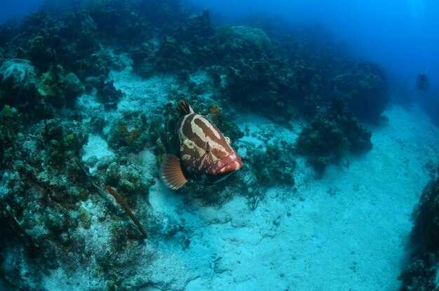
Begin in Cozumel at dawn; warm water often runs 27–29°C, and that allows a smooth drift through the wall topography. Palancar Reef shows green coral gardens with vibrant colors; Santa Rosa Wall drops steeply, offering dramatic vertical faces; Columbia Reef offers a secret drift through deeper channels where bigger pelagics cruise. Nudibranchs stud the surfaces, bull sharks appear seasonally, and many small fish animate the colors. Access from San Miguel is straightforward, and protection zones keep these worlds safe for being and playful life–making everything better again through June visibility.
In Riviera Maya, Tulum Wall delivers a long, graceful drift along a ledge that hosts meticulous corals and colors in depths from 6 to 24 m; Paamul Reef adds a kinder option with gentle slopes through 6–18 m and many macro creatures including nudibranchs. The best conditions cluster in May–June and again in September–October, when visibility is strong and the warm water supports vibrant topography near shore. Accessibility from Playa del Carmen or the town beaches makes this region better for snorkeling and easy swims.
Puerto Morelos keeps a calmer tempo with La Bocana and El Bajo. La Bocana offers a lighter drift along a protected reef edge, accessible from the village, with max depths around 15 m; El Bajo hosts bigger pelagics and schooling fish, great in June and often in the fall, with clear water and playful turtles. These sites sit inside a protected patch of the Mesoamerican Barrier Reef, which enhances access and protection for future seasons and preserves the secret feeling of the region.
| Zone | Site | Access | Max Depth (m) | Best Time | Signature Feature | Wildlife |
|---|---|---|---|---|---|---|
| Cozumel | Palancar Reef | Boat from San Miguel | 15–30 | May–Sept | Colorful gardens, swim-throughs | Green morays, parrotfish, nudibranchs, nurse sharks |
| Cozumel | Santa Rosa Wall | Boat | 18–35 | Mar–Oct | Dramatic vertical wall | Schooling fish, turtles, occasional bull sharks |
| Cozumel | Columbia Reef | Boat | 18–50 | Jun–Oct | Deep channels, pelagic drift | Pelagics, groupers, reef sharks |
| Riviera Maya | Tulum Wall | From Playa del Carmen or Tulum | 6–24 | Mar–Jun | Long wall drift, vibrant corals | Barracuda, sea turtles, reef sharks |
| Riviera Maya | Paamul Reef | Paamul Beach | 6–18 | May–Sept | Gentle slopes, coral gardens | Angelfish, morays, nudibranchs |
| Puerto Morelos | La Bocana | Puerto Morelos town access | 6–15 | Jun–Sept | Light drift along reef edge | Nurse sharks, morays, turtles |
| Puerto Morelos | El Bajo | Puerto Morelos town access | 12–20 | Celoroční | Pelagic action, large schools | Manta rays, barracuda, tuna |
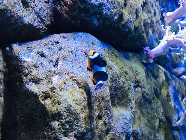
Cenotes: selecting by cave type, depth, and light exposure
Choose a shallow open cenote with bright daylight, a reachable wall, and calm water as your must-start option for the first visit. This setup works well for people, including families, and their reaction is often positive when exits are direct and the surface is visible from below. If the water feels cold at the surface, slip on a light wetsuit and take a gradual approach before moving deeper later.
Three cave type families shape your day: open cenotes that flood with sun, semi-open sites with a partial roof, and cavern routes where light fades and walls tighten. Each type is different: open sites reveal corals and clear lines on the wall, semi-open spaces balance shade and color, and cavern paths reward meticulous navigation along a guided route. Their features help you pick the right setting for activities and comfort, and others in your group can join at their own pace.
Depth matters. Shallow zones below 8 m ease learners into buoyancy and signaling, mid-depth ranges 8–20 m reveal larger walls and more life, while deeper pockets 20–40 m demand meticulous planning, a certified guide, and sign-up prior to entry through the site’s safety system. Always confirm the depth at the entrance and stay within your training level.
Light exposure defines mood and color. Bright sun near openings creates vivid outlines, while deeper or shaded sections show a cooler, blue-green glow that changes how corals and formations appear. Plan to visit around mid-morning or late afternoon to balance light, shadows, and visibility; this helps photographers and casual visitors alike, again for a different lighting effect.
Book with a reputable operator; sign-up ensures a structured day with a direct briefing, a safety system, and clear limits on depth and exposure. In addition to cenote time, you can add surface activities and nearby reefs or reef encounters; around the yucatan coast, including holbox and other spots along the caribbean coast, these options broaden the experience and increase the chances to see sharks when seasonal conditions permit. This balanced approach provides something for every person and keeps the pace comfortable for families and first-timers.
Examples you might consider: Dos Ojos offers extensive passages through cavern and open sections; Gran Cenote presents clear water with bright surface, and Ik Kil delivers a dramatic deep shaft. These sites show how depth and light interplay; here on the peninsula you’ll find people who went for a variety of experiences, including visitors from around, and others who want to focus on mindful exploration among the reefs and cenote walls.
Seasonal visibility and water conditions by month
Plan February through April for the clearest sea visibility and comfortable temperatures. Expect calmer mornings and steady currents near reef edges, ideal for multiple excursions along the Riviera Maya and Cozumel region.
- Leden
- Visibility: 15–25 m
- Temperature: 25–27°C
- Current and winds: light to moderate; NE winds in the morning
- Notes: reef edges stay clear on most days; shallow zones show excellent visibility
- February
- Visibility: 18–30 m
- Temperature: 25–28°C
- Current and winds: light to moderate; mornings are usually calm
- Notes: east-facing reefs often display sharp clarity; stable days near offshore sites
- Březen
- Visibility: 25–35 m
- Temperature: 26–29°C
- Current and winds: generally mild; best results after sunrise
- Notes: optimal windows along Cozumel and the reef corridor
- Duben
- Visibility: 28–40 m
- Temperature: 26–29°C
- Current and winds: stable; dry spell supports long, clear windows
- Notes: near-shore zones stay clean; schedule early slots for the best light
- May
- Visibility: 20–32 m
- Temperature: 27–30°C
- Current and winds: breeze increases; brief showers possible
- Notes: turbidity can rise after rain; mornings are ideal
- June
- Visibility: 18–28 m
- Temperature: 28–30°C
- Current and winds: winds pick up; seas can be choppier on exposed sites
- Notes: flexibility helps; check forecasts for offshore routes
- Červenec
- Visibility: 15–25 m
- Temperature: 28–31°C
- Current and winds: humidity high; showers frequent
- Notes: morning windows improve clarity; offshore reefs remain productive
- August
- Visibility: 15–25 m
- Temperature: 29–31°C
- Current and winds: warm, often breezy; storm risk rises
- Notes: plan with a flexible schedule; some days offer excellent clarity
- September
- Visibility: 15–25 m
- Temperature: 29–30°C
- Current and winds: rainy season in full swing; turbidity after rain spikes
- Notes: cenotes stay reliable; choose mornings after dry spells
- October
- Visibility: 20–30 m
- Temperature: 28–30°C
- Current and winds: post-storm stabilization; mornings are clearer
- Notes: early planning helps, especially for offshore routes
- November
- Visibility: 25–35 m
- Temperature: 26–28°C
- Current and winds: dry-season pattern begins; winds moderate
- Notes: the region shows strong clarity; nearshore shelves offer stable conditions
- December
- Visibility: 20–40 m
- Temperature: 25–27°C
- Current and winds: north swells possible; mornings often calmer
- Notes: end-of-year slots yield excellent light and long sightlines
Cenotes offer reliable clarity year-round; temperatures stay in the mid-20s °C, with mornings delivering the best light through skylights for photography.
Currents, depths, and safety planning for reef and drift dives
Book a guided, licensed drift session with a local operator who provides a surface marker buoy, reel, and a clear exit plan. Ensure a meticulous safety briefing, check current forecasts, and confirm exit options before entering the water. If winter here brings cooler water, wear a 3–5 mm wetsuit and stay ready to adjust pace; most drift routes around the Yucatán deliver a bucket-list moment when you move with the healthy balance of current and buoyancy, creating a memorable encounter with the natural world and its species. The oceans can be calm yet demanding, so prepare five core steps to stay ready and safe.
-
Currents, angles, and site selection – In this region, surface flows are driven by trade winds and tidal exchange. Most reef lanes run 0.5–1.5 knots on calm days; in calmer morning windows you gain a little more control, while afternoons can bring stronger push toward the back reef. Look for controlled entry points and exit options that align with your plan, such as channels that offer predictable paths back to the shore. Keep an eye on olhos–the eyes of the reef area seen by guides–as indicators of activity and visibility shifts; if the water looks green and murky, slow and reassess. Always have a plan for back-up exits and avoid routes with sharp cross-currents.
-
Depths and bottom time – Typical reef sections stay around 12–18 m, with some wall zones dropping to 20–25 m. For drift-lane safety, plan a bottom time of 25–40 minutes in calm conditions, then add a 3–5 minute safety stop at 5 m. If current accelerates, shorten bottom time accordingly and ascend earlier to maintain a second safety margin. Average gas reserves should be checked against the planned time and depth, aiming to finish the session with a comfortable reserve.
-
Five essential safety checks – Use a short, meticulous checklist before every session:
- Forecast and currents: verify the latest update and confirm that exit routes remain viable.
- Equipment readiness: SMB/reel, whistle, knife, spare gas if available, and a buoyant belt; confirm buddy signals.
- Buoyancy and trim: practice a light, controlled glide with minimal fin work to reduce impact on the water column.
- Site plan and angles: agree on a primary route, back-up exit, and contact points for the team.
- Gas management: ensure reserve, plan the second stage of the mix, and pace work to avoid early depletion.
-
Safety equipment and communication – Carry a surface marker buoy, signal whistle, and a cutting tool; a reel helps you manage drift when currents shift. Communicate with your buddy using agreed hand signals and maintain visual contact as you approach potential narrowing points or silt zones. On calmer days, you may explore closer to green slopes; on stronger days, stay nearer to the exit and maintain a steady rhythm to keep the group balanced.
-
Environmental awareness and site-focused choices – Respektujte mořský život a dodržujte bezpečnou vzdálenost od kritických stanovišť. Vyberte si trasy, kde můžete pozorovat přirozené chování, aniž byste zasahovali do volně žijících živočichů, například do puklin korálových útesů nebo mělčin, kde se běžně pohybují druhy jako papoušci mořští a andělíčci mořští. Všímejte si, jak proud tvaruje vaši cestu přes zelené řasy podobné mořským řasám a písčité plochy; plánujte možnosti, které minimalizují kontakt s křehkými korály a maximalizují příležitosti k pozorování malých přirozených jevů, jako je hejnování ryb a aktivita měkkýšů.
Posteriorní plánování se zaměřuje na bezpečné rezervy a realistické možnosti, nikoli na posouvání hranic. Dobře zvolená trasa snižuje stres na vaše druhé stádium a podporuje zdravou rovnováhu mezi průzkumem a bezpečností. Pamatujte: nejzajímavější okamžiky přicházejí z klidných, kontrolovaných pohybů, promyšlených úhlů a silného, kooperativního týmu – zde v tropických oceánech Yucatánu, kde zimní teploty směřují k polovině 20 stupňů Celsia a cílem je zůstat připraveni, metodičtí a ohleduplní k planetě, kterou sdílíme s nesčetnými druhy.
Kontrolní seznam výstroje a bezpečnosti pro potápění Quintana Roo
Proveďte důkladnou kontrolu vybavení před vstupem do vody na pláži alespoň 30 minut před jakoukoliv ponornou aktivitou. Ověřte si, že regulátor a první stupeň, alternativní zdroj vzduchu, zařízení pro řízení vztlaku, závaží a počítač jsou v souladu se specifikacemi, a ujistěte se, že je uskladněna nabitá záložní svítilna a náhradní baterie v suchém vaku.
Mějte u sebe záložní zdroj vzduchu, jasné hlavní světlo, náhradní popruh k masce a bezpečnostní cívku nebo lano pro cenoty nebo úseky korálových útesů. Měli byste mít s potápěčským kolegou jasný plán na kontakt v případě, že se sníží viditelnost nebo se změní proudy.
Důležitá je povědomí o hloubce: Certifikace Open Water obvykle omezuje do 18 m (60 stop). Pro hlubší možnosti absolvujte kurz Deep nebo Tec a doprovázejte kvalifikovaného průvodce. V cenotech si naplánujte maximální hloubku podle zkušeností a řiďte se pokyny průvodce. Požadujte podrobný briefing před vstupem do jakékoli zóny.
Divoká zvěř a životní prostředí: Karibské útesy hostí želvy a orelní papuče; dodržujte odstup a nepronásledujte je. Karibský život útesů je uctíván místními obyvateli a potápěči; pozorujte z respektující vzdálenosti.
Ochranná opatření: Používejte opalovací krém šetrný k mořským ekosystémům na souši, vyhýbejte se jeho nanášení v blízkosti hladiny vody a chraňte pláž a korálové útesy tím, že se budete držet vyznačených cest a nedotýkáte se korálů. Vezměte si s sebou malý sáček na odpadky a opakovaně použitelnou láhev, abyste snížili množství odpadu.
Možnosti vybavení a přístupu: Quintana Roo nabízí půjčovací vybavení a vedené výlety; Playa del Carmen a okolní pláže mají obchody. Existují i další možnosti, včetně obchodů na pobřeží a na Cozumelu. Pokud jedete autem, vyjeďte brzy, abyste se vyhnuli dopravní zácpě a měli více času na kontrolu vybavení. Měl by být čas na kontrolu na poslední chvíli po příjezdu.
Plánování mimořádných událostí a důvěryhodné zdroje: noste povrchové signalizační zařízení, znáte místní nouzové telefonní čísla a mějte plán, jak se rychle vzdálit, pokud se podmínky zhorší. Zdroj osvědčených postupů je založen na letech zkušeností sdílených místními přispěvateli; tito přispěvatelé, kteří jsou aktivní již po mnoho let, vedou nové potápěče a následně vám pomáhají s důvěrou prozkoumat Karibik. Znalosti od zkušených průvodců mohou umožnit bezpečnější rozhodnutí a následně vám pomohou užít si scenérii.