

 Boating Navigation – Essential Tips & Tools for Safe, Confident Cruising">

Začněte každou cestu kontrolním seznamem před odjezdem.Aktualizujte grafy, ověřte známé nebezpečí, nastavte navigační body a potvrďte údaje o počasí a přílivu. Během příprav zajistěte, aby čas posádky byl věnován jediné, strukturované rutině. To snižuje nečekané události na poslední chvíli a pomáhá přijímat aktualizace do 10 minut, pokud se podmínky změní.
Tradiční dovednosti se prolínají s moderními systems. Používejte kontrolu kompasu společně s elektronickými námořními mapami a AIS. Zobrazit situace nad vodou i pod ní, pomáhající při navigaci v rušných kanálech. Provádějte průběžnou bezpečnostní kontrolu: zkontrolujte hasicí přístroje, záchranné vesty a signalizační zařízení.
Poznámky k přístupným postupům: udržujte konzervativní rychlost v přeplněných kanálech (6–8 uzlů), dodržujte zavedené trasy a keeping vychutnejte si klid mimo rušné plavební cesty. Proveďte rychlou 2minutovou kontrolu po každém vjezdu do přístavu a poté pokračujte v plánování s novými daty.
Během cest poblíž green markery, ověřte směry podle známých orientačních bodů, plyne čas a měřte accuracy proti odlivovým tabulkám. V bavorských řekách se přizpůsobte úzkým kanálům a silnějšímu proudu.
Sdílejte plánovací data s posádkou, zaznamenejte notes o odchylkách a aktualizovat záznamy po každé směně. V případě náhlého situace, spustit alarm, přepnout na záložní systems, a udrž time na mysli.
Boating Navigation: Magnetická kompasová navigace – Praktické tipy a nástroje pro bezpečnou a sebevědomou plavbu
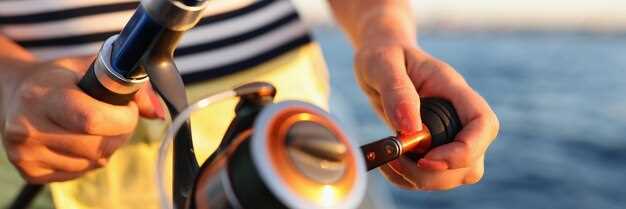
RecommendationNainstalujte robustní magnetický kompas s přehledným rámečkem, umístěte jej na chráněné a nezasahující místo a mějte na palubě záložní offline kompas. Během plavby pod plachtou porovnávejte kompasový kurz s orientačními body a mapou, abyste vytvořili spolehlivý zdroj pravdy, i když selžou elektronika.
Jak číst ložiskaUrčete záhlaví zaměřením na pevný bod a odečtením azimutu z lunety; poté proveďte úpravu podle aktuální deklinace a, pokud je to nutné, odchylky od vlastního systému vaší lodi. Zaznamenejte stupně, minuty a sekundy jako zkratky na terénní list a také si poznamenejte něco jako S, J, Z, Z pro rychlou orientaci. Některé kroky snižují chybu za větrných podmínek.
Používejte orientační body podél trasy k potvrzení vypočítaného kurzu; pamatujte také na to, že rychlé změny větru nebo poryvy mohou loď odklonit od čistě magnetického směru. Jako zálohu používejte pevné body na souši, které jsou viditelné z přístavišť a známé z plánovacích map. Kombinace kormidelného kompasu a nezávislého zdroje informací vás udrží na správné dráze i v případě selhání GPS.
Kontrolní seznam vybaveníUjistěte se, že kompas je vybaven a správně namontován; zkontrolujte kabely nebo zapojení, pokud je součástí většího systému; mějte připravenou záložní baterii, aby přístroj zůstal funkční, když vypadne hlavní napájení. Nainstalujte druhé zařízení jako rychlou zálohu a označte instalační oblast výstražnou cedulí pro střídání posádky. Zkontrolujte informace u marin ohledně magnetických rušení v blízkosti kabelů přístavního napájení; bavaria nabízí místní vedení od úřadů; používejte je jako jediný zdroj pravdy.
Plánujte a procvičujtePři vytváření plánů si poznamenejte oblast a potenciální místa s magnetickými rušeními (v blízkosti napájecích kabelů, motorů nebo zátěží). V ekonomických termínech noste kompaktní laminovanou mapu magnetické variability podle oblasti. Lodníci by měli střídat magnetický kurz a pravý kurz na námořní mapě, aby se předešlo odchýlení. Tento zvyk zvyšuje jistotu, zejména v noci nebo v mlze.
Všimněte siSledujte motorové kabely a elektrické vedení, abyste předešli rušení; udržujte oblast kolem kompasu volnou od feromagnetických předmětů, vyhýbejte se kovovým ozubeným kolům a udržujte přenosná zařízení v dostatečné vzdálenosti od kompasu; dodržujte orientační vzdálenost v nohách od zdroje, který může zkreslovat údaje. Nebezpečí požáru v blízkosti palivových hadic vyžaduje rychlou reakci a odstranění, pokud jiskru způsobí povel. Lodníci v přístavišti by měli používat provoz s jedním motorem, pokud se spoléhají na magnetické směry; pokud zaznamenáte odchylku, znovu zkontrolujte s mapou a upravte podle požadavků úřadů.
Offline operace zůstává praktické při dlouhých plavbách; to souzní s vlastnictvím a systémovým přístupem, což zvyšuje odolnost při výpadku napájení nebo elektroniky. Techniku lze testovat v různých podmínkách prostředí; bavorské pobřeží nabízí kopce, které mění přehled na orientační body, proto se spoléhejte na tyto orientační body k ověření směru. Mějte jediný, ekonomický set, který zahrnuje náhradní baterii, laminovanou polní kartu s zkratkami a jasné plány pro přepínání mezi magnetickým směrem a zakreslenými kurzy.
Magnetická kompasová navigace: Základní postupy pro bezpečnou a sebevědomou plavbu
Vždy nastavte magnetický kurz směrem k zamýšlené trase před odletem, pak to ověřte pomocí druhé metody, například GPS nebo orientačních bodů. Tímto udržíte kurz i ve vodách ovládaných proudy a změnami směru větru a umožníte si tak plachtit s větší jistotou.
Regular learning a following strukturovaný class pomáhá budovat awareness of rozdíly mezi kompasovými měřeními a skutečným směrem. Použijte offline practice k posílení svalové paměti: houpejte kompasem, porovnávejte s daty z námořní mapy a zaznamenávejte pozorování do vašeho ownership notes.
Uchovejte ruční a stacionární přístroje v službazkontrolujte, zda nejsou praskliny, vyměňte rámeček a zajistěte, aby... poplatek is adequate for backup devices. When trips involve fishing nebo přicházející around shoals, use the bearing to steer a secure arc a znovu zkontrolujte pravidelně.
Lodní doprava by měla rozumět tomu, že many ovlivňují odečet: lokální variace, rozdíly me mapou a displejem, a dopad kovových předmětů. Vždycky si udržujte data from multiple means in mind and together develop a robust habit to stay on course.
A practical routine: check direction, then recheck after a turn or change in water, currents, or wind; keep a log, review awareness data after each tripa include notes on how technologie a products performed offline and online.
Pre-Departure Compass Check: Declination, Deviation, and Swing
Set your magnetic compass to the latest declination from the updated chart or источник on deck, then lock the setting. Cross-check with the deviation table to ensure the numbers reflect current waterways, and log the change in a quick table aboard to support your plans and trips. Document the detail of the adjustment to aid crew work during pre-departure checks.
Compute the true heading by applying two corrections to the observed compass heading: deviation (D) from the vessel’s deviation table, and variation (V) from the chart. Use the equation TC = CH + D + V, with signs taken from the sources. Example: CH 090°, D = +2°, V = +5° yields TC 097°. When D or V are negative, adjust accordingly to keep your plotting on the intended type of course.
Perform a swing check while berthed: rotate the wheel through 360 degrees and compare the compass reading with a fixed reference bearing from landmarks or a charted line on the plotter. Note what you observe, expect swing to stay within roughly 0–6° on a typical hull; larger swing indicates residual magnetism or nearby damage. If you detect excess swing, pause, reassess deviation data, and rely on a quick, powered backup such as GPS overlay to confirm the route while you adapt.
If the hull or compass shows damage, or interference from gear is suspected, rely on a gyro compass or GPS-based track as a stand-in. When youre plotting trips through channels, a lake passage, or long waterway legs, keep a stand-on bearing in mind and enable a quick cross-check with the GPS plot to stay carefree and on plan.
Document the updated data in a dedicated table on deck, mark источник as the data source, and share the results with everyone aboard, including the charter crew. This detail keeps your plans aligned, reduces risk during long trips, and enables carefree travel between water channels.
Reading the Compass at the Helm: Navigating with Pitch, Roll, and Spray
Lock the helm and confirm a stable bearing by aligning a magnetic compass with sense4boat data, and use aids such as a gyro or fluxgate to cross-check readings; verify signal quality via hdop readouts, which is more accurate than a single instrument. If the numbers drift beyond ±3 degrees after a 15-second check, then re-center and re-check against the tide.
On deck, shifting seas produce spray that fogs the compass card. Keep your gaze through the binnacle, practicing calm helm corrections, and react quickly to small deviations; blasts from waves can push readings off, so strive to adjust before another span passes. This reduces collisions, a clear advantage in distress situations. Stay mindful of regulations.
Bilge pump readiness matters; ensure lines are clear and checks don’t interfere with cockpit instruments.
Learning updates from a network of owners, Bavaria sail owners, and suppliers of products keep you informed. Sense4boat readings, hdop trends, and numbers flux matter more than a single instrument. Informed care stays steady; you become more capable as conditions change through dives, tide, blasts, and gusts, and the approach can feel carefree yet precise. This significantly sharpens decision making.
| Condition | Action | Poznámky |
|---|---|---|
| Pitch > 5° or roll > 6° | Return to bearing; recenter; cross-check hdop | Cross-check with sense4boat; then lock |
| Spray obscures readout | Recenter; adjust to keep readings aligned | Keep eyes on cards; monitor spots |
| Reading drifts on spots | Record numbers; compare with network updates | Become consistent; updates help |
Correct for Variation and Deviation in Real-Time Bearings
Always validate bearings in real time by cross-checking magnetic readings with GPS positions and known visual cues, including buoys and upstream references to confirm alignment with the intended course.
- Baseline setup: pull local variation from a current chart or offline apps, then set that value in your compass settings and the electronics display, creating a single reference used in quick checks.
- Continuous cross-check: maintain alignment between magnetic bearing and GPS-derived course; compare positions against marina charts and a few fixed marks; when a discrepancy is detected, adjust bearing values immediately and log changes with concise abbreviations.
- Crew responsibilities: assign a quick observer to watch visual cues and buoys; keep the crew informed, involve your electrician when hardware readouts drift, and ensure the log is updated with care.
- Interference and drift: be mindful of blasts from nearby equipment or power lines that can shift readings; recalibrate, verify compass alignment, and test against a known set of courses to restore accuracy.
- Offline resilience: if connectivity or apps go offline, rely on positions, visual cues, and a trusted set of tracks; maintain a small record of bearings, positions, and courses to speed real-time decisions.
- Maintenance discipline: keep electronics well maintained, replace batteries, and review settings regularly; theres a need to verify readings after any calibration, and the crew should review the log after every trip; involve your electrician for a hardware check.
- Reference tools: use marina charts, buoys, and equipment to confirm alignment; with many inputs, accuracy improves; always align your heading with a good visual reference and a backup from apps or GPS.
Cross-Check Bearings with Charts, GPS, and Visible Landmarks
Check bearings against three sources: charts, GPS, visible landmarks before every leg. In practice, run the three-source check to confirm your position within the area, then update as you move. This approach increases accuracy when approaching busy zones such as wakeboarding zones, and when dealing with depths that change with tides.
- Charts and abbreviations: Read the fundamental bearing shown on the chart. Use the chart source; verify scale, grid, declination, and abbreviations in the legend. Note depths in the area and record what you see in your log tables to reference later.
- GPS and sensors: Compare GPS bearing with chart bearing; check sensor status, time, and update rate. If readings diverge beyond a small margin, switch to dead reckoning and relying on landmarks until readings align. Set an alarm if drift persists beyond 2–3 minutes.
- Visible landmarks: Identify at least two fixed features on shore or buoys; take visual bearings to each, compare with chart positions, and verify your location every few minutes. This critical step helps when GPS is degraded or signal is limited.
- Handling discrepancies: If misalignment exceeds a preset threshold, execute a rapid cross-check using what you know about depths and the ship’s wake. Update course gradually to reestablish your path.
- Record keeping: Save information in a dedicated log; include time, location, measured bearings, and notes. Refer to books or class materials, and fill in tables with abbreviations you can glance quickly. This ensures everything is captured.
- Practical practicing: Before class or during drills, run this routine on a known journey route. Practicing increases tolerance to misalignment as you sail near zones and other craft. What you learn here becomes baseline behavior when sailing in unsettled conditions. This practice will increase your accuracy.
Maintaining the Compass: Cleaning, Storage, and Magnetization Prevention
Start with a clean, magnetically neutral base: wipe the compass face with a soft microfiber cloth, rinse with fresh water, and dry thoroughly. Use a mild soap if needed; avoid solvents. Keep the unit above the deck to minimize moisture ingress and prevent water marks on the glass. After cleaning, verify the north reference against a distant mark or marks on a chart, confirming accuracy before heading out on the journey.
Maintain proper storage: when not in use, place the compass in a dry, cool container away from ferrous hardware, high-current cables, and any electronic sensors that could induce stray fields. The goal is to keep the dial balanced; avoid exposure to ferrous metals that can magnetize the dial. Store with the face up to help back bearings and maintain readability.
Magnetization prevention: keep the instrument away from beidou antennas and other magnet sources around the cockpit; a single magnet can cause drift, producing multipath-like errors when plotting routes. If you notice drift, perform a simple calibration against a known north reference. This must be part of your awareness at all times.
Simple checks during plotting: use sense4boat to compare compass output with GPS sensors; taking updates from authorities when away from shore; stay aware of distances and routes to limit collisions. If sensors show a discrepancy, develop understanding that a great deal of external influence can upset readings and adjust accordingly.
Charter crews, especially in bavaria, must stay aware of a routine that keeps the compass reliable. Start each day by checking alignment, and stay prepared with a back-up bearing. The aim is a carefree journey with reliable bearings, while authorities oversee safety and distances to other vessels along busy routes.
Regular checks create awareness of multipath and external interference that sensors may reveal. Building understanding of how external factors affect readings helps you stay able to plot more accurately. A simple, repeatable routine–clean, store, magnetization precautions–keeps distances and routes accurate, making back-up bearings usable when conditions are rough. Stay mindful of authorities and be proactive in maintaining performance on the journey ahead.