

 Paddle Through Paradise – Kayaking Biscayne National Park">

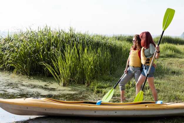
ابدأ عند الفجر من مكان تأجير مرموق، واتبع الطرق الرسمية. بما أن الضوء ألطف، سترى المزيد من ثعابين السمك وأشجار الغُمبُو لِيمْبُو على طول الشاطئ. تُبقيك الخطة الموضوعة حول البحيرات الضحلة في بيسكاين قريباً من المناظر الخلابة دون حشود، وتساعد الحقائب الجافة ذات اللون الليموني مجموعتك على البقاء ظاهرة في الفجر. لا ترتجل الملاحة عند تغير اتجاه الرياح - فالسلامة تتفوق على الرفاهية في كل مرة، ولديك طريق واضح لبداية هادئة ومجزية.
اعتبارات المسار: ابدأ بالقرب من القطع الموجود في الطرف الشمالي ومر عبر قنوات المانغروف حول الجزر الصغيرة. نقطة طريق يسميها السكان المحليون دانتي يجلس على حافة صخرية، بزاوية شمس لطيفة لالتقاط الصور. يعرض الخط الساحلي مناظر لسهول الشعاب المرجانية وأحواض الأعشاب البحرية، مع ظهور جزر على شكل أراجيح كصور ظلية داكنة في حالة المد العالي. إذا كنت تريد مشاهدة الحياة البرية، فإن ساعات الصباح الهادئة حول تغير المد والجزر تخرج طيور البلشون والأشعة والدلافين في بعض الأحيان؛ حافظ على هدوئك ودع إيقاع الماء يحملك.
علم البيئة والحياة البرية: تشتهر النظم البيئية في بيسكين بوضوحها وتنوعها. وبما أنك ستنجرف عبر ضفاف ضحلة، فقد تلمح ثعابين تنحني تحت جذور المانجروف وأسراب من أسماك المنوة الزجاجية تنزلق حول الشعاب المرجانية. تظلل أشجار الغمبو لمبو الشاطئ، ويشعرك موطن الأرجوحة السميك نفسه بأنه خالد، حيث تبقى الغابة مرنة حول كل منعطف. وتبدو المنطقة بأكملها حول مدخل هادئ وكأنها لم تمس تقريبًا، مكان يمكن أن يأتي فيه النوم بإيقاع طويل ولطيف، إذا احترمت الوتيرة وتجنبت الإزعاجات الصاخبة.
Gear and safety: استأجر من شركة تأجير موثوقة، واختر قاربًا خفيفًا مزودًا بسترة نجاة مناسبة وصفارة وخريطة. تحافظ حقيبة جافة بلون الليمون على جفاف العناصر المهمة، وتضيف مجموعة إسعافات أولية صغيرة الثقة. لا تفرط في تحميل قاربك؛ زجاجة ماء صغيرة ووجبات خفيفة سريعة تجعل يومك أكثر سلاسة. للحماية من الشمس، ضع واقيًا من الشمس آمنًا للشعاب المرجانية وارتدِ قبعة؛ بعد صباح ثابت، قد تتوق إلى أخذ استراحة في أرجوحة شبكية على شاطئ هادئ. ضع في اعتبارك الـ list من العناصر الأساسية والتعديل بناءً على المد والجزر والرياح.
نومٌ هنيء. بانتظار أولئك الذين يسيرون بخطى ثابتة طوال اليوم، ويسمحون للساحل بالكشف عن شخصيته دون تسرّع، مناظر طبيعية خلابة وآفاق واسعة. تُعرف هذه البانوراما بإمكانية الوصول إليها للمبتدئين وأولئك الذين تجولوا على الشواطئ بفضول. إذا غامرت حول حافة المنطقة المحمية، فستغادر بتقدير أعمق لإيقاع المد والجزر، وهمس أشجار المانغروف، والسحر الهادئ لمنطقة ترتدي تاريخها بخفة.
التجديف العملي في خليج بيسكين من شاطئ ميامي
انطلق مع أول ضوء من الطرف الجنوبي لشاطئ ميامي وادفع بقارب مائي يمكن الاعتماد عليه؛ واتبع الشريط الساحلي لمدة ساعة تقريبًا في مسار هادئ ومحفوف بأشجار المانغروف على طول حافة البحار. يبقى المسار بعيدًا عن القنوات المزدحمة، مما يزيد من فرص مراقبة الحياة الغنية للطيور وأشجار جوز الهند ومشاهدة الفراشات على طول الشاطئ. ثم توقف لتناول وجبة غداء صغيرة في خليج محمي قبل العودة. تحدَّ الحشود وابْقَ قريبًا من الشاطئ لتجربة أكثر هدوءًا.
مساران عمليان: مسار دائري بطول 3-4 كم يبدأ من ساوث بوينت بالقرب من المنتزه الساحلي ويتبع المسطحات القريبة من الشاطئ باتجاه الشارع الأول، ثم يعود على طول قناة موازية؛ يغطي هذا الممر المواقع الساحلية الشهيرة ذات المناظر الخلابة. ولركض أقصر، قلّص المسافة إلى 1.5-2 كم عن طريق ملاصقة أطراف أشجار المانغروف والكثبان الرملية؛ في كلتا الحالتين، ابقَ بين الخلجان الهادئة وممرات العبور الرئيسية لتقليل المخاطر من القوارب.
السلامة والتوقيت: تحقّق من توقعات الرياح والبحر قبل الانطلاق؛ توفر أيام الصيف المعتدلة جلسات مريحة، ولكن عطلات نهاية الأسبوع تجلب المزيد من حركة المرور. خطط للنزهة قبل الساعة 10 صباحًا وتجنب ذروة الشمس. ارتدِ سترة نجاة، واحمل خريطة مقاومة للماء، وأحضر قبعة شمس والكثير من الماء، والتزم بمسافة رؤية الآخرين لتحقيق السلامة المطلقة.
قائمة معدات: زورق مائي، حقيبة جافة، ملابس احتياطية، خريطة، زجاجة ماء، واقي شمسي، قبعة، وكاميرا صغيرة الحجم. احزم وجبة خفيفة مناسبة للنزهات مثل الفاكهة والبسكويت؛ ماء جوز الهند لطيف في الاستراحة. استخدم حقيبة مقاومة للماء للأشياء الثمينة، واحرص على تثبيت المعدات لتقليل التعرض للرياح؛ قد تتبلل بالرذاذ، لذا أحضر طبقة إضافية إذا كنت تريد أن تبقى مرتاحًا طوال اليوم. أبكار تذكّر الإرشاداتُ المجدِّفين بتقليل الأثر البيئي وتجنب إزعاج الحياة البرية.
نقاط الانطلاق والأصول: ابدأ بالقرب من ساوث بوينت عند ممر فيرست ستريت، مع توفر مواقف للسيارات على جانب الطريق في الصباح. التزم بالقنوات المخصصة، واحترم الحياة البرية في غابات المانغروف الضحلة، وتجنب المنعطفات المفاجئة التي قد تفاجئ الصيادين والقوارب الأخرى. أقصر طريق، ولكنه لا يزال خلابًا بشكل لا يصدق، يبقيك جنوبًا وبين الحواف الساحلية، مما يسمح بخروج سريع إذا زادت الأمواج أو تدهورت الرؤية.
نصائح بعد المهمة: عُد بمعدات مبللة وجففها ثم قم بتوضيبها. إذا رصدت صيادين جامايكيين أو قوارب محلية تعمل بالقرب من القنوات، امنحهم مساحة ومر من الجانب البعيد لتقليل الاحتكاك. التجربة الشاملة لا تُنسى للعائلات والمستكشفين المنفردين على حد سواء، فهي توفر فرصًا رائعة لمراقبة الحياة البحرية، والتوقف في مكان للنزهة، ثم العودة إلى الشاطئ تحت نسيم عليل هذا الصيف.
أفضل مسارات الكاياك للمبتدئين في منتزه بيسكين الوطني
تُعَدّ حلقة "إليوت كي" الساحلية أفضل مغامرة أولى: ممر مائي محمي مشهور يتميز بمياه ضحلة وهادئة وجداول المانغروف. يبلغ طول الرحلة ذهابًا وإيابًا حوالي 2.5 ميل، وينهي معظم المجدفين الرحلة في غضون 1.5-2 ساعة بوتيرة مريحة. تحدث أفضل الأحوال الجوية في فترة شهر هادئ، وغالبًا ما يوفر شهرا أبريل أو نوفمبر رياحًا خفيفة. ارتدِ بذلة غوص إذا كان الهواء أو الماء باردًا، واحمِل زورقًا عالي الجودة مع حقيبة جافة للأشياء الأساسية. إذا كنت ترغب في تجربة إرشادية، فتحدث مع مرشدين من المعاهد المحلية الذين يمكنهم تصميم رحلة تجديف قصيرة والتأكد من بقائك داخل القنوات المحمية. سترى الشعاب المرجانية الطبيعية قبالة الشاطئ، وبالقرب من حالة الجزر الساكن، ستجد تجاويف غارقة تدعوك لإلقاء نظرة فاحصة. تجول بعض المجدفين في خلجان هادئة وأبلغوا عن ضوء سماوي يتسلل عبر الغطاء النباتي. يوفر هذا المسار فرصة ممتازة للانزلاق فوق المياه الزجاجية، وبناء الثقة، والاستمتاع بمشاهدة الحياة البرية مع مجموعة صغيرة أو بمفردك.
-
حلقة إليوت كاي الساحلية
- المسافة: ~2.5 ميل ذهابًا وإيابًا
- التضاريس: مسطحات ضحلة، وأنفاق أشجار المانغروف، تيار مائي ضئيل
- أفضل فترة زمنية: التوقعات الهادئة شائعة في الربيع وأواخر الخريف
- الميزات: الشعاب المرجانية الظاهرة من الماء والبالوعات المائية العرضية
- المعدات: بدلة غطس للأيام الباردة؛ ارتدِ طبقات مقاومة للماء؛ مركبة مائية عالية الجودة
- مرشدون: تقدم المعاهد رحلات تمهيدية؛ سيشرحون لك المد والجزر والملاحة.
- السلامة: ابقَ في القنوات الرئيسية؛ انتبه لحركة القوارب من اليخوت القريبة
- نصائح: هذا المسار هو أساس متين لمهارات التجديف وممارسة الإنقاذ الذاتي الأساسية
-
دائرة شاطئ بوكا تشيتا كي
- المسافة: ~3 أميال ذهابًا وإيابًا
- التضاريس: قنوات محمية، بحيرات ضحلة، مسطحات رملية
- الميزات: أرصفة لليخوت بالقرب من الشاطئ؛ شعاب مرجانية قريبة لإطلالة سريعة
- :سبب كونه مناسبًا للمبتدئين: مياه هادئة ومحمية مع رياح يمكن التنبؤ بها
- المعدات: واقي شمسي؛ بدلة غوص اختيارية في الفترات الباردة؛ معدات مقاومة للماء
- :أدلة: رحلات عالية الجودة متوفرة؛ يمكن للمعاهد تخصيص خدماتها للقادمين الجدد
- السلامة: خطط للعودة قبل اشتداد نسيم البحر؛ وتجنب العبورات الطويلة
- ملاحظات: هناك خط ساحلي واسع بما يكفي للرسو من أجل استراحة قصيرة للمشي وتناول الوجبات الخفيفة
-
ممر آدمز كي المنغروفي
- المسافة: ~ ميلين ذهابًا وإيابًا
- التضاريس: غابات المانغروف الكثيفة، والجداول المدية، والقاع الرخو
- الميزات: قنوات طبيعية بها طيور وأسماك؛ مياه صافية عند مستويات المد والجزر المتوسطة
- لماذا هي مناسبة للمبتدئين: جيوب محمية ومياه بطيئة ويمكن التنبؤ بها
- المعدات: بذلة غوص إذا كان الجو باردًا؛ أحضر وجبة خفيفة وماء.
- إرشادات: خيارات لمقدمات إرشادية؛ يمكن للمجدفين ذوي الخبرة الانضمام للحصول على نصائح
- Safety: stay inside marked routes; watch shallow margins during low tide
- Tips: APCAR map indices help identify entry points and safe exits
-
Sand Key Flats to Gull Point Loop
- Distance: ~1.5–2 miles round trip
- Terrain: broad sandy shallows, seagrass beds, occasional current pockets
- Features: otherworldly light on calm mornings; easy paddling with wildlife viewing
- Why beginner-friendly: short distance, straightforward paddling, shallow water
- Gear: wear a wetsuit when temps drop; sun hat and UV protection
- Guides: many operators offer short introductory trips; ideal for practicing strokes
- Safety: monitor boat traffic in inlet zones; stay within sheltered zones when possible
- Notes: theres room to combine with a short, primitive shoreline hike if desired
Weather, tides, and daylight planning for Miami Beach paddlers
Begin at first light on weekends to catch calmer water and cooler air; finish two hours before sunset; verify tides and winds 24–48 hours ahead using NOAA forecasts and local tide tables. Choose locations with calm waterways and nearby mangroves, where reefs peek through clear shallows. For first-timers, pick fully sheltered routes and keep your watercraft within easy reach of shore. Expect occasional traffic from visitor boats and yachts; if you observe large wakes, alter course toward deeper channels. Mark turtle trails and rookeries on your map; look for shaded palms along calm shorelines with hammocks waiting. Plan trips that fit your day, and prepare everything you need in a dry bag before launch. Ready your gear, your sunscreen, and your water bottle so you are ready to go.
Tides and currents: typical daily swing is about 1–2 ft; launch near high tide to maximize water depth near reefs and inlets. Inlets and channels can produce stronger flows, especially when seabreeze shifts after mid-day. Nearby waterways often see chop building toward shore; stay on protected routes where birds roost and turtles surface near rookeries. Keep clear of yachts anchored in busy harbors; yield to larger craft when in doubt. Bring drinking water and a compact map for quick checks of tide windows and safe exit points. If you notice a black-water area, steer toward lighter colored shoals for visibility.
Daylight planning: Daylight hours range seasonally from about 10 hours in winter to roughly 14 hours in peak summer; plan trips with a hard stop 60–90 minutes before last light. Watch for afternoon storms; monsoon showers often build after lunch. For the rich biodiversity in coastal zones, avoid congested areas on weekends; keep ready maps of reefs, turtle corridors, and rookeries. Remember to drink water and apply sunscreen; your small bag should contain a light and a whistle in case you stay out longer than expected. Forget bringing too much gear; keep it compact and fully secured.
Wildlife etiquette: Respect rookeries and turtle nesting sites; maintain distance from birds and avoid loud noises that cause birds to fly away. Park your craft away from coral heads; if you must land, choose sandy beaches with palms and optional hammocks. Do not drink near nesting sites; take trash back in a dry bag. Watch for nearby yachts or visiting boats and give space to higher-speed vessels when crossing channels.
Gear and safety: Have a fully ready watercraft and personal flotation devices for everyone, plus whistle and waterproof light. Bring drinking water and snacks; carry a map with recommended locations and a plan in case of adverse weather. Store valuables in a waterproof bag; mark Dante on your map as a note if you want a storytelling waypoint. Do not rely on alcohol; protect skin with sunscreen and wear a hat. In reef-edge zones, stay alert to submerged rocks; keep to sheltered routes and avoid black-water zones where visibility is poor. Palms line the shore; finish with a quiet return along protected channels.
Safety gear, paddling etiquette, and wildlife rules in the park
Always wear a USCG-approved life jacket (PFD) and carry a whistle when you set out. Ensure a snug fit, fasten the waist belt, and test buckles before departure. Bring a dry bag with a phone, a compact first-aid kit, and a waterproof light. For more-detailed guidance, consult official signage at each launch.
Pack weather-appropriate, quick-drying layers and a rain shell for showers; keep valuables in a waterproof bag. Apply broad-spectrum sunscreen (SPF 30+), wear a hat, and consider coconut-scented sunscreen. Use lightweight clothing to stay cool, stay hydrated, and enjoy the salt-spice aroma carried by the breeze.
Etiquette on the water: stay to the right side of traffic lanes, yield to sailboats and charter vessels, and pass others with a wide arc. Keep a steady, predictable direction and avoid abrupt turns. When crossing between channels, communicate with a wave and align with the flow of currents to stay between markers and points; often the safest approach is to keep to a single, visible line and follow posted directions.
Wildlife rules: Absolute minimum distance from bonnethead sharks and other wildlife is 50 feet; do not pursue, touch, or feed. Maintain at least 50 feet from manatees and stay clear of nesting sites along mangroves. If wildlife approaches, pause and let it pass; never chase birds or discard trash.
Habitat protection: Avoid trampling seagrass beds in any of the designated areas; stay out of coral formations and anchor only in sandy zones or on designated moorings. Use official launches and follow posted restrictions; in deeper areas, drift with the current rather than dragging gear. Respect mangroves and shorelines, keep lines organized, and minimize impact on this fragile ecosystem.
Access and logistics: Mainland access points provide accessible launches to scenic routes; be mindful that the area is busy with sailboats and charters. The waterway can feel like a highway at peak times; give commercial traffic wide margins and ride the flow. In late afternoon, winds shift and showers may appear; always check official forecasts. On the everglades coastal stretch, tidal channels can change quickly, so plan accordingly. With a more-detailed plan, you’ll reach awesome overlooks and deeper mangroves along the main channels that bring spice to your day, and even a coconut-scented breeze may accompany your adventure.
Pairing kayak trips with top Miami Beach boat tours
Begin with a 90-minute paddling circuit in mild dawn light, gliding through Cutler Creek and adjacent mangrove creeks, then shift to a flagship yacht tour that departs from the marina. Florida coast access, official hours, and clear seas make this pairing practical for both beginners and families.
Choose a bundled package that links both experiences. The renowned operator Jones curates routes that kick off with calm paddling and culminate in a wide-water cruise, letting you spot frigate birds and distant landmarks. When april humidity climbs, the paired day stays comfortable because sea breezes remain predictable and temperatures stay mild.
april conditions vary, but humidity can rise; breezes still keep the pace comfortable for most guests while you compare the creeks to open bays and enjoy the scenery.
For a flexible itinerary, book the morning paddle and a later yacht tour with a brief intermission ashore. This approach reduces crowds, increases photo opportunities, and adds extra value for thousands of visitors who come each year. The crew includes guide named dante, with specialists to tailor pace and equipment to your skill level, making it easy to forget the heat and stay focused on wildlife and scenery.
| Pairing | الخبرة | Duration | Best time | الملاحظات |
|---|---|---|---|---|
| Paddling loop in creeks + coastline yacht tour | Renowned Miami Beach boat ride | 1.5 hrs paddling + 2 hrs cruise | Early morning to late afternoon | Humidity moderate; cold fronts uncommon; official hours posted; extra gear recommended |
| Paddling among mangroves + offshore frigate watch | Frigate sightings with skyline views | 1.25 hrs paddling + 1.5 hrs cruise | Sunrise or late afternoon | april and Thanksgiving packages often offered; package deals available |
| Calm bay paddling + luxury yacht brunch | Relaxed coastal cruise with onboard bites | 1 hrs paddling + 2 hrs cruise | Late morning | Kids welcome; Jones leads guest crews on select departures |
| Evening paddle + after-dark yacht ride | Moonlit channels and harbor lights | 1 hr paddling + 90 min cruise | Dusk | Official hours may vary; check april schedules |
Seasonal windows and optimal times for paddling Biscayne National Park
Recommendation: start at first light during the cool season (november through april) and chase nearly windless hours before 9:00. This window yields glassy flats near hammocks and palms, reduces glare for wildlife viewing, and often allows a complete outing before sea breezes build.
Winter to early spring favors sheltered routes in mangrove creeks and toward shallow channels. Plan departures around high tide or within two hours on either side, which keeps navigation safer and reduces grounding risk. In this period, the best options are low-traffic mornings and rapid return by late morning, when gusts from the southwest begin to pick up later in the day. For night-friendly plans, clear skies reveal cassiopeia high overhead, turning a simple outing into a brief stargazing session.
As spring shifts into summer, storms and heat increase. Aim for pre‑dawn starts around 6:00–8:00 am and wrap up by 1:00 pm to avoid building convection and lightning risk. Bring sunscreen and deet, wear light layers, and carry extra water. Occasional high humidity can reduce visibility, so choose routes with breeze breaks and shaded corridors rather than open flats whenever possible.
Autumn offers a transitional window that often mirrors spring’s calm pockets. Start earlier to beat late-afternoon squalls, and monitor sea state charts for a rise in chop from passing fronts. Nearly all sheltered passages stay accessible, with routes that stay toward mangrove edges remaining the most forgiving for novices and families on a picnic outing.
Route options balance convenience and scenery: street-accessible launches along the base areas provide straightforward starts, while more remote options reward exposure to vast flats and secret hammocks. To maximize safety, combine a reputable briefing with proactive tide planning and avoid grounding by choosing routes that stay within two feet of high-water marks.
Gear and etiquette: pack light, breathable clothing, a map or GPS, and a compact first-aid kit. Carry enough water, sun protection, and deet for mosquitoes near palm groves and hammocks. Respect conservation guidelines, stay on marked channels, and avoid disturbing nesting sites–these are secrets that protect wildlife and preserve the experience for future outings. The practice is called responsible paddling, and the source for best practices is a trusted local outfitter or educational pamphlet, ist источник of your planning. For those seeking extended trips, several base options near reputable outfits offer guided excursions that align with conservation standards and community input.
When planning time toward your schedule, consider apcar guidance and the preference of your group. If you want a longer stretch, a combination of sheltered creek routes and open-water crossings delivers an amazing balance of exposure and safety, easily fitting into a single day. Final tips: check weather and tide forecasts, prepare for mosquitos with deet, and always carry a signaling device. With thoughtful timing, you can enjoy a low-stress, high-reward outing that respects the environment and delivers memorable views of the lagoons, cordgrass, and palms that define this region’s character.